Quantcast
Channel: SKYE on AOL
Viewing all 4069 articles
Browse latest View live

Heavy Snow, Ice to Bear Down on Midwest, Northeast

$
0
0
Friday, Feb. 28, 2014
Winter Weather
(AP Photo/Matt Rourke)

March may not come in like a lion everywhere across the nation, but winter will roar during the first several days of the month and impact more than 100 million people.

Early indications are that a long-duration snow event will expand from the northern Rockies and central Plains to portions of the Midwest and Northeast in the days ahead.

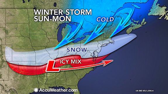
The adverse winter conditions will develop Friday into Saturday over the Plains and is forecast to shift slowly eastward Sunday and Monday. Snowfall from the west to east storm will exceed a 1,500-mile stretch on its journey.


Several storms will slice eastward in the snow area this weekend with the main storm forecast to roll out Sunday to Monday.

People traveling by road or airways should expect major delays as this area of snow expands eastward and crawls along. While some gaps are likely in between the storms, snow or a wintry mix could fall for 36 hours over a several-day stretch some areas in the central Plains and the middle part of the Mississippi Valley.


It is during the last part of the storm train, when the heaviest snow is likely to fall. This is projected to be Sunday to Monday over the northern part of the Ohio Valley to part of the central Appalachians and Monday into Monday night in the coastal Northeast.

For a time, the snow will impact areas between the I-70 and I-90 corridors over the Rockies and Plains and the I-64 to I-80 corridors in the Midwest and East.

Major airport hubs from Kansas City, Mo., Chicago, St. Louis, Indianapolis, Detroit, Cincinnati, Pittsburgh, Washington, D.C., Philadelphia, New York City and Boston may all be affected by the storm.

RELATED:
Rough Winter to Lag Well Into March for Midwest, East
Heaviest Rain in Months Heading to Southern California
AccuWeather Winter Weather Center


Initially, the storm will evolve into a blizzard over the northern Rockies and northern High Plains with dangerously low AccuWeather RealFeel(R) temperatures.

Farther east, the storm may be less intense in terms of wind and low RealFeel extremes, but precipitation can be quite heavy and very disruptive. The storm is likely to impact not only travel, but also school and business activities. The storm may completely tap remaining ice-melting supplies in some communities.


According to AccuWeather Chief Meteorologist Elliot Abrams, "The challenge with this storm is figuring out where the north-south boundary between rain and snow will set up and migrate to as the storm progresses slowly eastward."

At this early stage, the storm has the potential to bring half of a foot to a foot of heavy wet snow along a 1,000-mile swath in the Midwest and East, with locally higher amounts. Snowfall rates at the height of the storm may reach 2 inches per hour. Ice is a concern for some areas as well.


"In a narrow swath, all or part of the storm will deliver snow that may be difficult to shovel and plow, due to its accumulation and weight," Abrams said.

A tremendous temperature contrast will set up from north to south with the storm. A distance of 100 miles could bring temperatures ranging from the 60s and 70s to the 20s and 30s and the difference between rain, ice and snow.

"Because of the great amount of moisture available to this storm, a narrow zone of heavy ice can occur with downed trees and power outages," Abrams said.

In the warm air on the southern flank of the storm, drenching rain and thunderstorms will occur. Long-duration rainfall will occur near the rain/snow line, while the potential for strong to locally severe thunderstorms sweeping through is greatest over the lower Mississippi Valley.

Details will continue to unfold over the next few days on the storm as to which areas are mostly likely to receive all snow or a change from snow to rain and vice versa, as well as the northern extent of the snowstorm.

RELATED ON SKYE: 20 Photos of Monster Blizzards


Permalink | Email this | Linking Blogs | Comments


Evacuations Ordered as Heavy Rain, Mountain Snow Aid California Drought

$
0
0
Friday, Feb. 28, 2014
L.A. Rainstorms Moved Through Quicker Than Predicted
Storm clouds gather over the skyline of downtown Los Angeles, California, U.S., on Thursday, Feb. 27, 2014. (Patrick T. Fallon/Bloomberg via Getty Images)

Another round of rain is moving into California to close out the week, bringing further relief from the extreme drought gripping much of the Golden State. However, the storm will cause some problems as well.

This rain began to move in Thursday night, right on the heels of the storm that brought rain to parts of the state on Wednesday. This second storm will have some differences though, including a heavier rain that will span across the entire state.

As beneficial as this rain will be, it does pose some dangers, particularly to those living in Southern California.

A mandatory evacuation due to a high probability of debris and mudflow was ordered Thursday in the Colby Fire Impact Area in Glendora, Calif., according to the Glendora Police Department's Facebook page.

The department said there is the risk of injury and/or death in the event of such a debris or mudflow.

A mandatory evacuation order has been issued in Azusa, Calif., for 11 residences that have been identified by the Los Angeles County Department of Public Works as having a high potential for mud flow flooding.


According to AccuWeather.com Western Weather Expert Ken Clark, "Rain will fall everywhere in the state Friday and Friday night with the heavy rain mostly in the southern third of the state."

This is a big difference from that storm that affected the state Wednesday into Thursday, as some residents of Southern California did not even see a drop of rain.

Not only will the rain help battle the drought, but heavy snow is also expected to fall in the mountains with several feet possible in the Sierra through Saturday. This snow is crucial during the warmer months when the runoff helps to fill water reservoirs downstream.

RELATED:
Ken Clark's Western U.S. Weather Blog
Drought-Stricken Southwest Tears up Lawns to Save Water
California Interactive Radar


Several inches of rain are likely through Saturday along the California coast with the heaviest rain focusing along the coast of Southern California.

"I would expect to see some amounts in the 6- to 8-inch range Friday into Saturday in the mountains with 4 to 6 inches in the spots in the lower foothills. This would include the recent burn area around the San Gabriel Valley," Clark said.

Periods of heavy rain are also in store for southern parts of Nevada and Utah as well as northern Arizona as the moisture associated with the storm travels inland.


The storm will bring some hazards with it. Heavy rain can quickly lead to flash and urban flooding. Mudslides are possible, especially in areas that have been affected by wildfires over the past several months.

Folks living in these areas are encouraged to have a plan in place in the event that you must leave your home with little warning.

Thunderstorms will also develop over Southern California on Saturday, bringing the risk of damaging winds and hail. A brief tornado or waterspout cannot be ruled as well.


So far this year, San Diego had received measurable precipitation on only four days totaling 0.50 of an inch. This equates to only 12 percent of what the city normally receives up to this point in the year.

According to the U.S. Drought Monitor report on Feb. 25, 2014, more than 90 percent of California was under a severe drought, and 74 percent under an extreme drought.

Although the rainfall through the weekend will help to lower these percentages, it will take much more rain to have a long-term impact on the current drought.

The chance of rain will return again to California during the first half of next week; however, most of this rain appears like it will stay mainly over the northern half of the state.

RELATED ON SKYE: 7 Surprising Health Effects of Drought


Permalink | Email this | Linking Blogs | Comments

Winter-Weary Americans Plead: Get Me Out of Here

$
0
0
Friday, Feb. 28, 2014
Winter-Fleeing the Freeze
In this photo taken Wednesday, Feb. 26, 2014, Sue Knieriemen, of Fremont, Ohio, and her brother Charles Bork, of Sylvania, Ohio, check their tickets outside Goodyear Ballpark before an exhibition baseball game between the Cincinnati Reds and the Cleveland Indians in Goodyear, Ariz. (AP Photo/Paul Sancya)

CHICAGO (AP) - Shannon Frauenholtz has had it with winter. Barely able to stomach the television news with its images of snowbound cars, she heads to the tanning salon, closes her eyes and imagines she's back in Mexico, where she's already vacationed once this winter.

She's toyed with the idea of joining her mother in Hawaii or just driving to an indoor water park, figuring that while the palm trees might be plastic and the "beach" smells of chlorine, at least it's warm.

"I don't need a vacation. I don't need the relaxation," she said. "I just need the heat."

All over the Midwest and the East Coast, travel agents are being inundated with a simple request: Get me out of here. And travelers fortunate enough to have escaped are begging hotels to let them stay a little longer.

Because they know how miserable people are, warm-weather destinations in California, Arizona and Florida have stepped up their enticements. Trains and billboards in Chicago have been plastered with ads showing beaches and pool scenes. In Philadelphia, one promoter put fiberglass mannequins dressed in flip flops, tank tops and shorts atop taxis with their arms outstretched - a whimsical inducement to "fly" south.

Reminding Americans that there are places where nose hairs don't freeze is an annual tradition. But those in the business of luring visitors to warmer climates say it's rarely been easier than this season, when "polar vortex" has entered the everyday vocabulary and "Chi-beria" has become popular enough to emblazon on T-shirts.

"This year we wanted to have a little more fun with it," said Susannah Costello, of Visit Florida, the state's official marketing organization, which came up with the mannequin idea.

The ads showing children and bikini-clad women making snow angels in warm beach sand are more plentiful than in years past, acknowledged Erin Duggan, of Visit Sarasota County.

"We did that because we knew winter was shaping up to be brutal," she said.

Not that people needed much reminding of the harsh conditions.

"The winter is so bad, there is a certain amount of desperation," said Alex Kutin, an Indianapolis travel agent. "They come and say, 'I've got to get somewhere warm. Where do you recommend?'"

Kevin Tuttle, of Verona, Wis., was so intent on finding warmth that he decided against Florida out of fear that the polar vortex might reach down and find them there. Instead, he and his wife will take their 4-year-old son and 5-year-old daughter to Manzanillo, Mexico, a resort on the Pacific ocean.

"That's near the equator, right? It's got to be pretty warm," Tuttle said, adding that "a lot of sand castles are in my future."

Just how many more people are trying to get out of the ice box is unclear. Airlines do not release any route-specific data. And although the government tracks some of it, figures will not be released for six months.

But other travel statistics suggest there has been a jump, including figures from Visit Florida that show hotel bookings in Florida rose 3 percent in the four weeks ending Feb. 15 compared with the same period last year.

The jetsetter.com travel site found that the number of hotel bookings in warm-weather spots made by customers from Illinois, New York, Massachusetts and the Washington, D.C., area rose 7 percent in January compared with last year.

Travelers are also staying longer once they arrive.

Micah Hilgendorf said the thought of heading back to ice-covered Chicago, where he owns a couple of bars, prompted him to tack on three days in Florida before and after a cruise out of Miami. He also flew to Palm Springs, Calif., for four days.

"All of that is last-minute because of the weather," Hilgendorf said.

Dave Knieriemen, a retired engineer from Fremont, Ohio, is doing the same thing.

"We've reserved a room for another night in case our flight gets canceled because of the weather," he said this week from Arizona as he watched the Cleveland Indians play a spring training game. "And it's so horrible (in Ohio) we might stay a bit longer, anyway."

Travel agents say the numbers of travelers would be even higher if all those who wanted to get away could find a seat on jets that are already full.

"It's far easier to find people a resort to stay in or a cruise ship than to find them a flight," said Gail Weinholzer, of AAA in Minnesota.

The inability to find a flight, afford a trip or get time off from work has sent a surge of customers to businesses closer to home that can offer even a short escape from the cold, such as tanning salons.

"We're getting a lot of people coming in here to warm up," said Kirstin Leffew, the manager of Bronze Bay Tanning in Pendleton, Ind. "They want the beds that have been used the most, the ones that are nice and hot."

Indoor water parks say they are busier than usual, too. Joe Eck, general manager of the Wilderness Resort in the Wisconsin Dells, said business is up 10 to 15 percent because of the bitter cold.

Among those who decided to go to the Wilderness - which has real palm trees, the resort will remind you - were Jennifer Drost and her family.

"Our kids are young enough where they still enjoy playing outside, but they haven't been able to because it was so darn cold," said Drost, who lives with her husband and three children in Fond du Lac, Wis. "All of us were getting on each other's nerves, (and) we just needed to get out of the house."

RELATED ON SKYE: The 30 Best Places to Watch the Sunset


Permalink | Email this | Linking Blogs | Comments

Photos: Skies Aglow Amid Northern Lights in UK

$
0
0
Friday, Feb. 28, 2014
A lighthouse in South Shields, U.K., creates a picturesque backdrop for the Aurora Borealis on Thursday, Feb. 27, 2014. (Photo/David West)

The Aurora Borealis, or Northern Lights, made a surprise visit to parts of the United Kingdom late Thursday night, Feb. 27, 2014.

Somewhat uncommon for the region, as the strongest events usually present themselves over England and Wales, according to AccuWeather Meteorologist Randy Adkins, this light show was the result of a solar flare that erupted on Feb. 25, 2014.

RELATED:
Detailed London Weather
United Kingdom Weather
Stormy Week for Western Europe

Regardless of the reasoning behind the phenomena, skies were illuminated with shades of green, pink, yellow, orange, red and purple late Thursday night, putting on a breathtaking show for viewers as far south as Essex.


Streaks of orange and yellow brighten the skies of Aberdeenshire, Scotland, as the Northern Lights make an appearance on Feb. 27, 2014. (Photo/James Youngson)


Residents experience quite the view, as the Northern Lights brought bursts of green and red light to the skies above Uttoxeter, North Staffordshire, U.K., late Thursday night, Feb. 27, 2014. (Twitter Photo/@RichardH082)


Glowing pink skies catch the eyes of many throughout Corbridge, Northumberland, U.K., as the Aurora Borealis make their 2014 debut in the area. (Photo/John Logan Photography)


Have questions, comments, or a story to share? Email Kristen Rodman at Kristen.Rodman@accuweather.com, follow her on Twitter @Accu_Kristen or Google+. Follow us @breakingweather, or on Facebook and Google+.
RELATED ON SKYE: 15 Dazzling Photos of the Northern and Southern Lights from Space
Aurora from Space


Read | Permalink | Email this | Linking Blogs | Comments

Photo: Storm Barelling Toward California Seen From Space

$
0
0
NOAA's GOES-West satellite captured this image of a storm system swirling toward California on Feb. 28, 2014, at 11:15 a.m. PST. When the photo was taken, bands of rain had already begun sweeping the drought-stricken state.

According to NASA climatologist Bill Patzert, "Californians haven't seen rain and wind this powerful in three years." Some areas could receive up to four inches of rain. For more info on the storm, click here.

RELATED ON SKYE: 50 Incredible Photos Showcasing Forces of Nature
Forces of Nature


Permalink | Email this | Linking Blogs | Comments

California Soaked But Little Drought Help, Damage

$
0
0
Saturday, March 1, 2014

Glendora city workers clear mud and debris from the hills, in Glendora, Calif., on Friday, Feb. 28, 2014. The first wave of a powerful Pacific storm spread rain and snow early Friday through much of California, where communities endangered by a wildfire just weeks ago now faced the threat of mud and debris flows. (AP Photo/Nick Ut)

AZUSA, Calif. (AP) - A storm that brought some of the highest rainfall totals to the Los Angeles area in years, including eight inches on some mountains, was just the beginning of what the region needs to pull out of a major drought.

Although the storm was expected to remain strong Saturday, forecasters said such systems would have to become common for the state to make serious inroads against the drought.

"We need several large storms and we just don't see that on the horizon," National Weather Service meteorologist Eric Boldt said Friday. "This is a rogue storm. We will dry out next week."

But the storm had yet to do serious damage either. At least not yet.

In Azusa and neighboring foothill communities about 25 miles east of Los Angeles that sit beneath nearly 2,000 acres of steep mountain slopes that just weeks ago were menaced by a wildfire, about 1,200 homes were under evacuation orders over mudflow fears but were so-far spared.

In particular danger were about a dozen homes in Azusa that were backed up against a steep fire-denuded hillside several hundred feet high that authorities feared could collapse.

Muddy water swept down the hillside earlier in the day, spreading about two feet of ooze above one backyard, although fencing walls and an orchard of about 5,000 avocado trees behind the development stopped most serious debris.

Despite the urging of police and fire officials who cleared reporters and others out of the neighborhood as the hill grew more saturated, at least a few residents decided to stay on.

Dennis Sanderson, 50, said his reaction to the evacuation order was "we'll ride it out," but by nightfall he was undecided and keeping an eye on the weather because of forecasts for more rainfall.

Only a half-inch of rain was expected late Friday night "but that doesn't mean that mountain won't come down, so we'll probably go ahead and leave," Sanderson said.

Ed Heinlein, 65, evacuated early Friday with five other family members including his 5-week-old grandson to stay with friends, but kept returning to eye the house and the mountain, where mud filled furrows more than three feet deep and brimmed over retaining walls three feet tall.

"It's your home and your life, so it's hard to stay away," Heinlein said. However, "We're not to go back until the threat clears."

About 13 homes were evacuated Friday night in Palmdale in northern Los Angeles County, where a mudslide closed a major road.

Thunder echoed and hard rain fell late Friday night on Hollywood, which was abuzz with preparations for Sunday evening's Academy Awards and hopes the rain will have moved on by then as expected.

Rainfall totals in parts of California were impressive, especially in areas that typically don't receive much, but not nearly enough to offer long-term relief from a long-running drought.

Three inches fell on Bel Air and Pasadena, and an urban flash-flood warning that was sent to cell phones was called late Friday night for central Los Angeles County.

For the first time in nearly three years, downtown Los Angeles received more than 2 inches - doubling its total for the rainy season that began in July, the National Weather Service said. Yet the city remained 7 inches below the normal 11 inches.

Meanwhile to the east in San Bernardino County, a levee failed and put eight houses in danger of serious flooding, but county fire crews were working to protect them and no evacuations were ordered.

Forecasters expected the storm to last through Saturday in California before trundling east into similarly rain-starved neighboring states. Phoenix was expecting its first noticeable precipitation in two months. The storm was projected to head east across the Rockies before petering out in the Northeast in several days.

Rain also fell along the central coast, the San Francisco Bay area and Central Valley.

Winter storm warnings were in effect in the Sierra Nevada. About 15 inches of new snow had fallen by mid-day Friday at the University of California, Berkeley's Central Sierra Snow Lab located at 6,900 feet elevation.

A tornado warning was issued for Sacramento, Yolo and Sutter Counties Friday night but was canceled soon after.

Farmer Ray Gene Veldhuis, who grows almonds, walnuts and pistachios and runs a 2,300-cow dairy in the Central Valley's Merced County, welcomed the wet weather but knew it would not rescue California from drought.

"Hopefully, they keep coming," Veldhuis said of the storms. "If not, we'll deal with the hand we're dealt."

Numerous traffic accidents occurred on slick or flooded roads across California, including one about 60 miles east of Los Angeles involving a big rig whose driver died after falling from a freeway overpass.

Power outages hit about 32,000 customers, the Los Angeles Department of Water and Power and Southern California Edison said.

The storm was good news for other Californians who didn't have to worry about mudslides.

Kite-surfer Chris Strong braved pelting rain to take advantage of strong winds that gave him about an hour of fun over the pounding surf in Huntington Beach.

"I don't get to kite here in these conditions very often - only a handful of times - but you put them in the memory bank," he said.

RELATED ON SKYE: Dramatic Photos Reveal California's Epic Drought


Permalink | Email this | Linking Blogs | Comments

St. Louis to DC, Philly: Major Travel Disrupting Snow Looms

$
0
0
Saturday, March 1, 2014

This file photo of a tractor trailer off the road in Chapin, S.C. shows what could be in store for travelers this weekend. (AP Photo/Mary Ann Chastain)

March may not come in like a lion everywhere across the nation, but winter will roar during the first several days of the month and impact more than 100 million people.

Snow will expand from the northern Rockies and central Plains to portions of the Midwest this weekend, reaching the Northeast and mid-Atlantic on Sunday through Sunday night.

The adverse winter conditions will continue to expand over the central Plains on Saturday and is forecast to shift slowly eastward on Sunday and Monday.

Snowfall from the cross-country storm will exceed 1,500 miles on its journey. There is the potential for more than 6 inches of snow to fall along a 1,000-mile stretch from Kansas City and St. Louis, Mo.; Peoria, Ill.; Indianapolis; Columbus, Ohio; Philadelphia; New York City, Trenton, N.J., and Washington, D.C. Some locations along this swath could end up with a foot of snow or more.


People traveling by road or airways should expect major long-lasting delays as this area of snow expands to the south and east.

For a time, the snow or an icy mix will impact areas between the I-90 and I-70 corridors in the Rockies and the I-90 and I-40 corridors in the Plains and Midwest and the I-90 and I-85 corridors in the Northeast and mid-Atlantic.

Snowfall rates at the height of the storm may reach 2 inches per hour, causing the snow to quickly clog major interstates.


Major airport hubs from Kansas City, Mo., Chicago, St. Louis, Indianapolis, Detroit, Cincinnati, Pittsburgh, Washington, D.C., Philadelphia, New York City and Boston may all be directly affected by the storm with the potential for thousands of delays and/or cancellations. Ripple-effect flight delays and cancellations are likely to reach nationwide.

One batch of snow will push slowly eastward on Saturday into Sunday from the Great Lakes to part of the central Appalachians. It is during this first batch where Chicago, Detroit and Buffalo, N.Y., are likely to get most of the snow from the event.

However, it is during the last part of the storm, when the heaviest and longest-lasting snow is likely to occur farther south in the Ohio Valley, Northeast and mid-Atlantic.

The heaviest snow is projected to be along the I-70 corridor from eastern Kansas to Pennsylvania on Sunday, then from the Ohio Valley to around the Mason-Dixon Line and the central coast of New Jersey Sunday night. On Monday, substantial snow and ice will center on the mid-Atlantic.

Initially, the storm will evolve into a blizzard over the northern Rockies and northern High Plains with dangerously low AccuWeather RealFeel(R) temperatures.

Farther east, the storm may be less intense in terms of wind and low RealFeel extremes, but precipitation can be quite heavy and very disruptive. The storm is likely to impact not only travel, but also school and business activities. The storm may completely tap remaining ice-melting supplies in some communities.

RELATED:
Rough Winter to Lag Well Into March for Midwest, East
California Rain Brings Drought Relief, Flooding
AccuWeather Winter Weather Center


According to AccuWeather Chief Meteorologist Elliot Abrams, "The challenge with this storm is figuring out where the north-south boundary between rain and snow will set up and migrate to as the storm progresses slowly eastward."

A tremendous temperature contrast will set up from north to south with the storm. A distance of 100 miles could bring temperatures ranging from the 60s and 70s to the 20s and 30s and the difference between rain, ice and snow.


"In a narrow swath, all or part of the storm will deliver snow that may be difficult to shovel and plow, due to its accumulation and weight," Abrams said.

Ice is a concern in between the heavy snow and soaking rain area.

"Because of the great amount of moisture available to this storm, a narrow zone of heavy ice can occur with downed trees and power outages," Abrams said.

A shift in storm track by as little as a few dozen miles and more of a press of cold air could make the difference between heavy snow, light snow, ice and rain.

In the warm air on the southern flank of the storm, drenching rain and thunderstorms will occur. Long-duration rainfall will occur near the rain/snow line, while the potential for strong to locally severe thunderstorms sweeping through is greatest over the lower Mississippi Valley.

RELATED ON SKYE: 15 Photos of Monster Blizzards


Permalink | Email this | Linking Blogs | Comments

Severe Storms to Threaten Central Texas to Mississippi Sunday

$
0
0
Saturday, March 1, 2014

As in this file photo, Texas and areas along the Mississippi River will receive strong thunderstorms with high winds and heavy rains. (AP Photo/Damian Dovarganes)

As a snowstorm travels across the central Plains and Midwest, the potential for severe thunderstorms will exist Sunday from parts of central Texas to along the lower Mississippi River.

Most of the storms are forecast to fire in an area bounded by the I-10 and I-20 corridors.

The greatest risks from the storms are urban flooding, large hail and damaging wind gusts. However, this setup may also bring a few tornadoes. As a result, people living in or traveling through the aforementioned area will want to keep an eye out for rapidly changing weather conditions.


According to AccuWeather Enterprise Solutions Severe Weather Meteorologist Tyler Dewvall, "The storms are likely to fire first near Dallas, Texas, early Sunday morning, where the main threats are likely to be large hail and urban flooding."

As Sunday progresses, the storms will expand and shift southward and eastward.

"The greatest risk for a few tornadoes is Sunday afternoon, and that is most likely in portions of northeastern Texas to near or just north of Houston," Dewvall said.

The storms are likely to continue farther east into Sunday evening. During this time, the storms will move into parts of Arkansas, Louisiana and western Mississippi. The primary threat of the storms will shift toward damaging wind gusts, along with a continued threat for blinding downpours, urban flooding and an isolated tornado.

RELATED:
Major Snowstorm Kansas to Massachusetts on the Way
California Rain Brings Drought Relief, Flooding
AccuWeather Severe Weather Cente
r

On the northern fringe of the severe weather area, including portions of Arkansas and northern Mississippi, a change to colder conditions could lead to ice or a wintry mix Sunday night.

During Sunday night into Monday, while the storms are likely to be less volatile east of the Mississippi River, there will be an ongoing risk for urban flooding and localized damaging wind gusts. This potential will exist from New Orleans to Montgomery, Ala., and Atlanta.

RELATED ON SKYE: 50 Must-See Weather Photos from 2013
Twin Waterspouts


Permalink | Email this | Linking Blogs | Comments


Photos: California Flooding 2014

Orion's Stars Shine Over Stargazers in Amazing Photos

$
0
0
Saturday, March 1, 2014

Night sky photographer Jon Secord is seen photographing the breakwater and night sky on the beach of Wallis Sands State Park in Rye, N.H. on Dec. 28, 2013 as constellation Orion passed overhead. (Aaron Priest, www.aaronpriestphoto.com)

When night sky photography friends get together, you'll likely find them looking up in places like the shores of Wallis Sands State Park in Rye, N.H.

Aaron Priest of Maine recently sent Space.com some spectacular photos taken during one such winter gathering.

The constellation Orion, the Hunter, can be spotted passing overhead in both shots. One of the most recognizable constellations in the sky, Orion includes several prominent stars including Betelgeuse, Rigel and Bellatrix. Seven of its brightest stars form an hourglass shape in the sky. [Amazing Night Sky Photos by Stargazers for February]

"I enhanced the stars of Orion a little bit to make the constellation easier to see in the sky," Priest wrote Space.com in an email.

Priest captured these images using a Nikon D700 camera, Nikon 14-24mm f/2.8 lens, and a Promote Control @ 14mm, f/2.8, ISO 6400, and four exposures of 8, 15, 30, and 60 seconds, manually blended via masks and layers in Photoshop.

To see more amazing night sky photos submitted by Space.com readers, visit our astrophotography archive.

Editor's note: If you have an amazing night sky photo you'd like to share for a possible story or image gallery, please contact managing editor Tariq Malik at spacephotos@space.com.

Follow SPACE.com on Twitter @Spacedotcom. We're also on Facebook & Google+. Original story on Space.com.

Copyright 2014 SPACE.com, a TechMediaNetwork company. All rights reserved. This material may not be published, broadcast, rewritten or redistributed.

RELATED ON SKYE: Mind-Blowing New Photos from Space


Permalink | Email this | Linking Blogs | Comments

Arkansas to West Virginia Face Greatest Ice Threat

$
0
0
March 1, 2014

As in this file photo, trees in the Mid-Atlantic region could be weighed down by a coating of ice. (Sara D. Davis/Getty Images)

It is not just substantial snow and severe thunderstorms accompanying the winter storm crossing the nation, but also a treacherous icy mix.

The most substantial snow will center on the northern Ohio Valley states and the mid-Atlantic Sunday through Monday.

Between the I-70 and I-40 corridors in the Plains, as well as the Ohio and Tennessee valleys, the snow will either start as or fall as an icy mix. The same can be said for the southern mid-Atlantic.

Within these corridors lie Amarillo, Texas, Oklahoma City and Tulsa, Okla., Wichita, Kan., Springfield, Mo., Little Rock, Ark., Memphis and Nashville, Tenn., Louisville, Ky., Charleston, W. Va., Washington, D.C., Dover, Del., and Richmond, Va.


The icy mix will spread over these areas in a general northwest-to-southeast fashion through Monday.

Communities along the border of Texas and Oklahoma will also be subject to sleet and/or freezing rain developing on Sunday. On Monday, rain will change to ice as far south as Raleigh and Greensboro, N.C.

Even where only a thin glaze is expected, the icy mix will make untreated roads and sidewalks extremely slick and treacherous.

RELATED:
Substantial Snow Crossing the US
AccuWeather.com Winter Weather Center
Latest Winter Weather Watches, Warnings


Substantial freezing rain could also lead to power outages. AccuWeather.com meteorologists feel that this threat is greatest from central Arkansas to Kentucky and southern West Virginia.

This includes Little Rock, Ark., Cape Girardeau, Mo., Paducah and Lexington, Ky., and Beckley, W. Va.

For Little Rock, the severe icing threat will come Sunday night after severe thunderstorms graze the city late Sunday.

RELATED ON SKYE: Icy Storm Hits Texas, Midwest


Permalink | Email this | Linking Blogs | Comments

Saturated Slopes Worry California Cities

$
0
0
Updated Saturday, March 1, 2014, 10:53 p.m. ET

A woman walks over the mud and debris at the corner of Sierra Madre Avenue and Highcrest Road along the hillside in Glendora, Calif. on Saturday, March 1, 2014. A burst of heavy showers before dawn Saturday impacted wildfire-scarred mountainsides above foothill suburbs east of Los Angeles, causing another round of mud and debris flows in the city of Glendora. (AP Photo/Ringo H.W. Chiu)

LOS ANGELES (AP) - Saturated mountainsides loomed over foothill communities on Saturday as a storm centered off California rotated bands of rain into a state that sorely needs the moisture but not at such dangerously high rates.

Evacuation orders remained in effect for hundreds of homes in Los Angeles County foothill communities where fires have burned away vegetation that holds soil in place, and bursts of rain caused the mountains to belch occasional debris flows.

The storm marked a sharp departure from many months of drought that has grown to crisis proportions for the state's vast farming industry. However, such storms would have to become common to make serious inroads against the drought, weather forecasters have said.

Officials warned of scattered showers through Saturday night before tapering off past midnight. While the danger was subsiding, they urged residents who left their homes as much as three days earlier to stay away until Sunday morning.

"The good news is that it looks like the storm will pass ... but we still need to evaluate the safety of the area" before people can return home, Assistant Chief Steve Martin of the Los Angeles County Fire Department told a webcast news conference.

The National Weather Service said the storm is forecast to move east over the Rockies and into the Plains and Mississippi Valley through Sunday, bringing a hodgepodge of precipitation. Colorado's ski resorts could see up to 6 inches of fresh snow. A mixture of sleet and snow in Kansas, Missouri and Illinois will eventually change over to all snow - with up to 8 inches forecast for Kansas City and the St. Louis area - while northern Arkansas will see freezing rain. The system also has its sights set on the Appalachians and the East Coast into Monday.

The storm's eastward move on Saturday finally broke a 70-day streak without precipitation in the Phoenix area. An 85-day spell of no measureable rainfall in Las Vegas ended Friday. Rain and snow also finally came to drought-stricken New Mexico. In Denver, a highway pileup involving more than 100 vehicles killed one person and injured 30 others as heavy snow fell Saturday, authorities said.

In California, about 1,200 houses in the adjacent cities of Azusa and Glendora as well as nearby Monrovia have been under evacuation orders because of the possibility of destructive flows from the San Gabriel Mountains, a rugged range largely covered by the Angeles National Forest. A dozen homes in Azusa were in particular danger.

Television news footage shows mud burying one backyard, swallowing a metal fence and reaching up to the rim of a basketball hoop.

"We've got to find a way to get the 100 tons of mud out of my backyard," Ed Heinlein told the Los Angeles Times about the damage to his Azusa property. "We're probably looking at tens of thousands of dollars in damage."

Forecasters said the upper-level low at the storm's center would come ashore and move east through the day, dragging rain with it but leaving only showers in California on Sunday - a lucky break for the evening's Oscar red carpet festivities in Hollywood.

The storm was the much more powerful second act of two systems that hit California during the week.

Downtown San Francisco has received 8.01 inches of rain by Saturday evening, bringing the city to 44 percent of its normal rainfall but avoiding the city's driest-ever "rain year" record by roughly half an inch, NWS meteorologist Matt Mehle said. The driest year was in 1851, with just 7.42 inches. The rain year begins July 1.

"All this rain has been really helpful but we are still behind the curve in terms of the drought," Mehle said.

Downtown Los Angeles tallied 4.34 inches from the second storm by 5 p.m. Saturday, said NWS meteorologist Joe Sirard in Oxnard. That raised the rainfall total to 5.54 inches since July 1, still 6.19 inches below normal.

Other trouble spots included about 13 homes that were evacuated Friday night in the Lake Hughes area in northern Los Angeles County after a mudslide closed a major road. To the east in San Bernardino County, a levee failed and put eight houses in danger of serious flooding, but county fire crews were working to protect them and no evacuations were ordered.

In Santa Barbara County, strong waves sent water crashing into a beachside restaurant in Goleta and three boats onto the sand and a pier, county fire Capt. Martin Johnson said. The restaurant's manager told KEYT-TV that one of his employees was swept out into the ocean and underneath the pier, where he was able to get out of the water. Another employee was pushed back inside the restaurant by a rogue wave but was not seriously hurt.

At the north end of Monterey Bay, strong waves apparently broke through the foundation of a seaside home, creating a blowhole on the driveway and shooting water over the roof. Also, a stretch of the oceanfront drive in Santa Cruz was shut down Saturday after a large sinkhole appeared in a cliff, opening the roof of a cave where homeless people have lived. Authorities said public works was investigating.

The storm was so volatile that a tornado warning was issued early Saturday for suburbs east of Los Angeles.

Numerous traffic accidents occurred on slick or flooded roads across California, including one about 60 miles east of Los Angeles involving a big rig whose driver died after falling from a freeway overpass. The Fresno County sheriff's office also reported a man was injured by lightning Friday.

Utilities were working to repair numerous scattered power outages.

RELATED ON SKYE: Photos Show California's Flooding


Permalink | Email this | Linking Blogs | Comments

1 killed, 30 Injured in Massive Colorado Pileup

$
0
0
Sunday, March 2, 2014

A deadly, giant pileup occurred on northbound Interstate 25 as a band of heavy snow moved through Denver. (Kathryn Scott Osler/The Denver Post via Getty Images)

DENVER (AP) - One person died and 30 others were injured in a massive pileup on Interstate 25 as a band of heavy snow moved through south Denver on Saturday, authorities said.

Police say 104 vehicles were involved in crashes along a roughly 2-mile stretch of highway as a short but intense burst of snow slammed the area. The northbound lanes were closed for several hours, but the interstate has since reopened. The injured were taken to nearby hospitals.

Drivers and passengers who were not hurt were put on a city bus to speak with accident investigators, and some wrecked cars were towed to a nearby high school, the Denver Post reported. Meanwhile, about 100 snowplows and four large tankers with deicing fluid were busy clearing roads throughout Denver, according to the Colorado Department of Transportation.

Meteorologists said the storm was part of the same system that has saturated California and is slowly moving across the West en route to the Plains and Mississippi Valley on Sunday.

"We're on the front leading edge of it, so there's some moisture coming up," National Weather Service meteorologist Jim Kalina said. That, combined with a cold front that moved into Colorado on Friday night, made for whiteout conditions and slick roadways across the state.

Highway officials closed the westbound lanes of a section of Interstate 70 west of Denver after treacherous road conditions led to numerous accidents. Traffic is still slow in the reopened lanes.

The transportation department warned that recently fluctuating temperatures in Colorado led to the slick road conditions, and authorities advised motorists to stock their vehicles with water, blankets, windshield wiper fluid, hand warmers and nonperishable food items.

Freezing drizzle and highs in the low 20s were expected in Denver on Sunday, making way for sunny skies and highs in the mid-50s by Monday.

RELATED ON SKYE: 20 Photos of Monster Blizzards


Permalink | Email this | Linking Blogs | Comments

Houston, Shreveport in Path of Severe Storms

$
0
0
Sunday, March 2, 2014


As a snowstorm travels across the central Plains to the Midwest and into the Northeast, the potential for severe thunderstorms will exist on Sunday across parts of Texas and Louisiana.

Most of the storms are forecast to fire in an area bounded by the I-10 and I-20 corridors.

The greatest risks from the storms are urban flooding, large hail and damaging wind gusts. However, this setup may also spin up a few tornadoes. As a result, people living in or traveling through the aforementioned area will want to keep an eye out for rapidly changing weather conditions.

"The greatest risk for a few tornadoes is Sunday afternoon, and that is most likely in portions of northeastern Texas to near or just north of Houston," AccuWeather Enterprise Solutions Severe Weather Meteorologist Tyler Dewvall said.

The potent thunderstorms will first ignite Sunday afternoon, then will spread the rest of the day and evening tracking to the south and east.

The thunderstorms will target Houston, Texas, and Shreveport and Lake Charles, La.

RELATED:
Major Snowstorm to Cross the US
South Central Regional Radar
AccuWeather Severe Weather Center


On the northern fringe of the severe weather area near the Arkansas border, a change to colder conditions will lead to ice or a wintry mix on Sunday night.

During Sunday night into Monday, while the storms are likely to be less volatile east of the Mississippi River, there will be an ongoing risk for urban flooding and localized damaging wind gusts. This potential will exist from New Orleans to Montgomery, Ala., and Atlanta.

RELATED ON SKYE: 50 Must-See Weather Photos from 2013
Lightning Hits the Grand Canyon


Permalink | Email this | Linking Blogs | Comments

Major Snowstorm Heads to DC, Philly, Richmond

$
0
0
Sunday, March 2, 2014

As in this file photo, a large swath of the U.S. will be digging out from under deep snow on Monday. (AP Photo/Rich Pedroncelli)

A storm crossing the country will create travel nightmares for millions from the Plains to the mid-Atlantic through Monday.

Snow will expand from the northern Rockies and central Plains to portions of the Midwest this weekend, reaching the Northeast and mid-Atlantic on Sunday through Monday.

Snowfall from the cross-country storm will exceed 1,500 miles on its journey. Along that journey, more than 6 inches of snow will occur along the Ohio River and just south of the I-70 corridor from Kansas City, Mo., to St. Louis to Cincinnati, to Clarksburg, W. Va., to Harrisonburg, Va., to Washington, D.C., to Philadelphia and Trenton, N.J.

Some locations along this swath could end up with a foot of snow or more.


People traveling by road or airways should expect major long-lasting delays as this area of snow expands to the south and east.

For a time, the snow or an icy mix will impact areas between the I-90 and I-40 corridors in the Plains and Midwest and the I-80 and I-85 corridors in the Northeast and mid-Atlantic.

Snowfall rates at the height of the storm may reach 2 inches per hour, causing the snow to quickly clog major interstates.


Major airport hubs from Kansas City, Mo., Chicago, St. Louis, Indianapolis, Cincinnati, Pittsburgh, Washington, D.C., Philadelphia and New York City may all be directly affected by the storm with the potential for thousands of delays and/or cancellations. Ripple-effect flight delays and cancellations are likely to reach nationwide.

One batch of snow will push slowly eastward through Sunday from the Great Lakes to part of the central Appalachians. Chicago, Detroit and Buffalo, N.Y. received their snow during this first wave.

However, it is during the last part of the storm, when the heaviest and longest-lasting snow is likely to occur farther south in the Ohio Valley, Northeast and mid-Atlantic.

The heaviest snow is projected to be just south of the I-70 corridor from eastern Kansas to Pennsylvania on Sunday. Accumulating snow will also drop southward to the Texas Panhandle and northern Oklahoma.

Sunday night, the heaviest snow zone will stretch from the Ohio Valley to around the Mason-Dixon Line and the central coast of New Jersey Sunday night. On Monday, substantial snow and ice will center on the mid-Atlantic.


The storm is likely to impact not only travel, but also school and business activities. The storm may completely tap remaining ice-melting supplies in some communities.

RELATED:
Rough Winter to Lag Well Into March for Midwest, East
Latest Winter Weather Watches, Warnings
AccuWeather Winter Weather Center


According to AccuWeather Chief Meteorologist Elliot Abrams, "The challenge with this storm is figuring out where the north-south boundary between rain and snow will set up and migrate to as the storm progresses slowly eastward."

A tremendous temperature contrast will set up from north to south with the storm. A distance of 100 miles could bring temperatures ranging from the 60s and 70s to the 20s and 30s and the difference between rain, ice and snow.


"In a narrow swath, all or part of the storm will deliver snow that may be difficult to shovel and plow, due to its accumulation and weight," Abrams said.

South of I-70, travel hazards will start even before the first flake of snow falls due to sleet and/or freezing rain preceding the snow. In some cases, this icy mix will come after a period of rain.

On Monday, that icy mix will occur as far south as Raleigh and Greensboro, N.C. As temperatures plummet Monday afternoon, roads can quickly turn icy.

Soaking rain would wash away any lingering salt or would prevent crews from treating roads prior to the ice or snow begins.

"Because of the great amount of moisture available to this storm, a narrow zone of heavy ice can occur with downed trees and power outages," Abrams said.

The area at greatest risk for the heavy ice and power outages lies from central Arkansas to southern West Virginia. This includes Little Rock, Ark., and Lexington, Ky.

A shift in storm track by as little as a few dozen miles and more of a press of cold air could make the difference between heavy snow, light snow, ice and rain.

In the warm air on the southern flank of the storm, drenching rain and thunderstorms will occur. Long-duration rainfall will occur near the rain/snow line, while the potential for strong to locally severe thunderstorms sweeping through is greatest over the Arklatex.

RELATED ON SKYE: 15 Photos of Monster Blizzards


Permalink | Email this | Linking Blogs | Comments


Iditarod Mushers Prepare for Start of Famous Race

$
0
0
Sunday, March 2, 2014

The dogs of Canadian musher Karen Ramstead, from Perryval Alberta, are decked out in appropriate colors as they cross the bridge to Goose Lake during the ceremonial start for the 2014 Iditarod Trail Sled Dog Race on Saturday, March 1, 2014, in Anchorage, Alaska. (AP Photo/The Anchorage Daily News, Erik Hill)

WILLOW, Alaska (AP) - A New Zealand man will be the first musher en route to the town of Nome when the Iditarod Trail Sled Dog Race begins today.

Curt Perano and 68 other mushers will begin the world's most famous sled dog race by crossing frozen Willow Lake about 50 miles north of Anchorage.

It's a staggered start, meaning one musher leaves every two minutes. The order was drawn at a musher's banquet Thursday night in Anchorage, and Perano got the leading spot.

The finish line is on Front Street in Nome, which runs parallel to the Bering Sea coast. Standing between the mushers and the finish line are about 1,000 miles of unforgiving Alaska terrain, including two mountain ranges, untamed wilderness, the mighty Yukon River and the wind-whipped Bering Sea coast.

Among those in the field are Mitch Seavey, last year's champion, and his son, Dallas Seavey, the 2012 winner.

"The last two winners might create more media interest," Dallas Seavey said before the race started. "But it doesn't mean that we're necessarily the two most competitive racers this year."

Adding to the uncertainty of this year's race is an influx of Scandinavian mushers, including two-time champion Robert Sorlie.

The Sunday event in Willow is officially called the race's "restart." It follows a ceremonial start Saturday in downtown Anchorage.

At that fan-friendly event, mushers talked to people and had their pictures taken for hours before their names were called to the start line. They then took their sleds on a leisurely 11-mile run on urban trails within the city, oftentimes with an auction winner, called an Iditarider, on the sled.

Mushers then trucked their dog teams and equipment up the Parks Highway to this community, which on clear days offers a stunning view of nearby Mount McKinley, North America's tallest peak.

The race turns serious today, and mushers were busy preparing their sleds for the race.

The Iditarod has a late-afternoon start, which allows fans from both Anchorage and Fairbanks, about 250 miles to the northeast, to make the trip.

PHOTOS ON SKYE: The 2014 Iditarod Trail Sled Dog Race


Permalink | Email this | Linking Blogs | Comments

Photos: The 2014 Iditarod Trail Sled Dog Race

Storm Threat Subsides in California

$
0
0
Sunday, March 2, 2014

Skiers crowd the slopes at Snow Valley, Calif. as a strong storm dumped fresh snow on the slopes Saturday, March 1, 2014. A powerful Pacific storm hit the state early Saturday, but did not put a major dent in a drought that is among the worst in recent California history. (AP Photo/The Press-Enterprise, Mark Muckenfuss)

LOS ANGELES (AP) - A thunderstorm that brought sorely-needed rain to drought-plagued California is winding down after sending mudslides down foothill communities, flooding roadways and opening up sinkholes.

Evacuation orders remained in effect for hundreds of homes in Los Angeles County foothill communities where recent wildfires have burned away vegetation that holds soil in place, and bursts of rain caused occasional debris flows.

The storm marked a sharp departure from many months of drought that has grown to crisis proportions for the state's vast farming industry. However, such storms would have to be much more frequent to make major headway against the drought, weather forecasters say.

The heavy band of rain drenched parts of the state throughout Saturday before tapering off by nighttime. While the danger of mudslides was subsiding, officials urged residents who left their homes as much as three days earlier to stay away until Sunday morning.

"The good news is that it looks like the storm will pass ... but we still need to evaluate the safety of the area" before people can return home, Assistant Chief Steve Martin of the Los Angeles County Fire Department told a webcast news conference.

The National Weather Service said the storm is forecast to move east over the Rockies and into the Plains and Mississippi Valley through Sunday, bringing a hodgepodge of precipitation. Colorado's ski resorts could see up to 6 inches of fresh snow. A mixture of sleet and snow in Kansas, Missouri and Illinois will eventually change over to all snow - with up to 8 inches forecast for Kansas City and the St. Louis area - while northern Arkansas will see freezing rain. The system also has its sights set on the Appalachians and the East Coast into Monday.

The storm's eastward move on Saturday finally broke a 70-day streak without precipitation in the Phoenix area. An 85-day spell of no measureable rainfall in Las Vegas ended Friday. Rain and snow also finally came to drought-stricken New Mexico. In Denver, a highway pileup involving more than 100 vehicles killed one person and injured 30 others as heavy snow fell Saturday, authorities said.

In California, about 1,200 houses in the adjacent cities of Azusa and Glendora as well as nearby Monrovia were under evacuation orders because of the possibility of destructive flows from the San Gabriel Mountains, a rugged range largely covered by the Angeles National Forest.

In Azusa, 3 to 10 feet of mud buried Ed Heinlein's backyard, swallowing a metal fence and reaching up to the rim of a basketball hoop.

"We've got to find a way to get the 100 tons of mud out of my backyard," Heinlein told the Los Angeles Times. "We're probably looking at tens of thousands of dollars in damage."

Forecasters predicted only showers in California on Sunday as the storm heads east - a lucky break for the evening's Oscar red carpet festivities in Hollywood.

The storm was the much more powerful second act of two systems that hit California during the week.

Downtown San Francisco received 8.01 inches of rain by Saturday evening, bringing the city to 44 percent of its normal rainfall but avoiding the city's driest-ever "rain year" record by roughly half an inch, NWS meteorologist Matt Mehle said. The driest year was in 1851, with just 7.42 inches. The rain year begins July 1.

"All this rain has been really helpful but we are still behind the curve in terms of the drought," Mehle said.

Downtown Los Angeles tallied 4.34 inches from the second storm by 5 p.m. Saturday, said NWS meteorologist Joe Sirard in Oxnard. That raised the rainfall total to 5.54 inches since July 1, still 6.19 inches below normal.

In the Hollywood hills, a mudslide took down a tree which knocked down a power pole, leaving homes in the neighborhood in the dark late Saturday.

Other trouble spots included about 13 homes that were evacuated Friday night in the Lake Hughes area in northern Los Angeles County after a mudslide closed a major road. To the east in San Bernardino County, a levee failed and put eight houses in danger of serious flooding, but county fire crews were working to protect them and no evacuations were ordered.

The storm also created problems from the sea.

Heavy surf in the Long Beach area caused mild to moderate damage to 20 homes on Ocean Boulevard, though no evacuations were required, the fire department said.

In Santa Barbara County, strong waves sent water crashing into a beachside restaurant in Goleta and three boats onto the sand and a pier, county fire Capt. Martin Johnson said. The restaurant's manager told KEYT-TV that one of his employees was swept out into the ocean and underneath the pier, where he was able to get out of the water. Another employee was pushed back inside the restaurant by a rogue wave but was not seriously hurt.

A fierce wave also broke the windows of a restaurant on the Santa Barbara pier.

At the north end of Monterey Bay, strong waves apparently broke through the foundation of a seaside home, creating a blowhole on the driveway and shooting water over the roof. Also, a stretch of the oceanfront drive in Santa Cruz was shut down Saturday after a large sinkhole appeared in a cliff, opening the roof of a cave where homeless people have lived. Authorities said public works was investigating.

The storm was so volatile that a tornado warning was issued early Saturday for suburbs east of Los Angeles.

Numerous traffic accidents occurred on slick or flooded roads across California, including one about 60 miles east of Los Angeles involving a big rig whose driver died after falling from a freeway overpass. The Fresno County sheriff's office also reported a man was injured by lightning Friday.

Utilities repaired numerous scattered power outages.

RELATED ON SKYE: Photos Show California's Flooding


Permalink | Email this | Linking Blogs | Comments

Wintry Weather Across Much of US, East Coast to Get Hit on Monday

$
0
0
Sunday, March 2, 2014

A city plow removes snow from an intersection along 6th Street in Lawrence, Kan., Sunday, March 2, 2014. (AP Photo/Orlin Wagner)

WASHINGTON - Tourists flocked to the monuments in the nation's capital Sunday to enjoy spring-like 50 degree temperatures after a winter of one blast of snow and sub-zero temperatures after another.

Joggers were out in shorts and T-shirts on the National Mall, home to treasured Smithsonian museums and landmarks like the Washington Monument and Lincoln Memorial. Families flew kites around the mall while tour guides led groups around the memorials. Cherry blossom trees were growing new buds for the spring.

But oh how so much can change in a matter of hours. More snow and ice, perhaps as much as 2 inches falling every hour, were on the way ahead of Monday's morning commute.

"I'm over it," said Yasmon Hanks, 24, of Hampton, Va., echoing thoughts of many who've been cooped up inside this winter. Hanks visited the Martin Luther King Jr. Memorial in Washington with her husband, Lynwood, and two young children. She was happy to be able to get outside, she said, because "I thought it was going to be way worse."

A round of wintry precipitation moved across much of the nation Sunday, bringing a mix of freezing rain and heavy snow to central and eastern states. Authorities warned of possible power outages and flight disruptions from weather that could affect millions.

Ken and Linda Mokry of Chicago took advantage of the 54-degree temperature in Washington to visit as many monuments as possible before the storm.

"You've got grass! We don't even have grass to see at home yet," Linda Mokry, 66, said. "We had our first snow right at the end of November ... and we've had snow ever since then, so we've had a long, long winter - way too long."

Ken Mokry noticed the cherry blossom trees are forming tiny buds, making him wish spring would arrive sooner so they could see the trees blossom in pink and white.

"I hope this cold snap doesn't hurt anything," he said. "We were really hoping that we would be able to see them. Maybe next time."

Much of the worst weather was expected to pound the East Coast. In Washington and the Mid-Atlantic region, forecasters predicted a layer of ice and 8 to 12 inches of snow possible on Monday. That could be enough to shut down schools and offices yet again this season.

The National Weather Service called for 6 to 8 inches of snow across parts of southern Pennsylvania. Nearly a foot of snow was expected in parts of New Jersey.

In Pittsburgh, snow began falling about dawn and was expected to taper off before another band of snow hits early Monday. Forecasters were expecting 3 to 6 inches total. Philadelphia was expected to get four to 8 inches through Monday. More than 6 inches would make it the city's second snowiest winter, surpassing 65.5 inches that fell in 1995-96.

Nearly 1,600 flights in the United States were canceled and another 1,515 delayed Sunday afternoon, according to flight tracking site FlightAware.com. The bulk of the problems were in Dallas, Chicago and Newark, N.J. Another 1,115 flights for Monday were also already canceled. There are more than 30,000 U.S. flights on a typical day.

In Ohio, among those braving treacherous conditions was Patty Lee, who drove some 20 miles from Cincinnati to suburban Blue Ash for a job interview. She joked that her first job test was making it through the icy parking lot without falling down.

"The roads are deteriorating pretty quickly," she said after returning to Cincinnati.

A suspension bridge over the Ohio River between Cincinnati and Kentucky was closed Sunday because of ice covering its hard-to-treat metal grid deck.

Freezing rain and sleet moved across Kentucky, making road travel treacherous Sunday. Officials warned residents to avoid unnecessary travel. Parts of the state could receive up to 8 inches of sleet and snow through Monday. Churches throughout the state canceled services.

The eastern West Virginia panhandle could get up to a foot of snow. That sent residents on a hunt for food, water and supplies.

In the Midwest, arctic cold temperatures hit Nebraska. Forecasters said Sunday's single-digit high temperatures could set records across the state. And wind chills 20-to-35 degrees below zero were reported Sunday.

Snowfall amounts across Indiana range from nearly 9 inches in northwestern Indiana to 1.7 inches in Indianapolis.

The same weather system inundated California with rain. Four hikers were rescued overnight after they became trapped by rising floodwaters in Malibu Creek State Park. Authorities were warning of mudslides and swollen creeks and drainage channels.

RELATED ON SKYE: 15 Photos of Monster Blizzards


Permalink | Email this | Linking Blogs | Comments

Major Snowstorm Looms for DC, Philly, Richmond

$
0
0
Monday, March 3, 2014
Winter Weather
A morning commuter walks to a train station during a winter snowstorm Monday, March 3, 2014, in Philadelphia. (AP Photo/Matt Rourke)

A far-reaching winter storm with substantial snow and ice will continue to track through the mid-Atlantic on Monday.

This will remain a complex winter storm with plunging temperatures setting the stage for treacherous ice and substantial snow. In some cases, the ice and snow are following a period of rain and even violent thunderstorms.

Fresh arctic air pouring into the Northeast will spare places from I-80 northward in the Northeast from the snowstorm. At most, an inch or so will graze the New York City area. Southern New England should escape with very little, if any, snow.

AccuWeather.com meteorologists have determined that the heaviest snow will instead focus farther south over the mid-Atlantic from the mountains of West Virginia to northern and central Virginia, Delaware, Maryland and southern New Jersey through Monday.

Washington, D.C., Harrisonburg, Va., Philadelphia, Dover, Del., and Atlantic City, N.J., are bracing for substantial snowfall that will total 6 to 12 inches. Some places will even see amounts top a foot.

Snowfall rates at the height of the storm may reach 2 inches per hour, causing the snow to quickly clog major interstates.

RELATED:
Latest Update on the Major Winter Storm
Latest AccuWeather.com Snowfall Forecast Map
Northeast Regional Weather Radar

Commuters will face extremely treacherous travel, along with lengthy flight delays and cancellations on Monday. Residents will be dealing with more disruptions to daily routines and school cancellations.

The impending snowstorm will come despite a mild end to the weekend across the mid-Atlantic with rain falling. Any wet roads or sidewalks will rapidly freeze as colder air arrives and the rain transitions to a period of ice, then the heavy snow.

Evident by the icy conditions that unfolded around Dallas earlier Sunday, arctic air is having no trouble pressing farther south than previously anticipated and AccuWeather.com is concerned for rain changing to a glaze of ice as far south as Florence, S.C., and Charlotte, N.C., later Monday.

Bridges and overpasses would be the first to turn icy, and snowflakes could even bring the ice to an end in Raleigh, N.C.

The concern for treacherous ice has also shifted southward west of the Appalachians. Nashville must now brace for the ice storm that is threatening to put Little Rock and Jonesboro, Ark., Memphis, Tenn., and Lexington, Ky., in the dark.

Invading colder air will cause rain to end as ice or lead to a rapid freeze up southward to northern Louisiana and northern Mississippi Sunday night.

As the ice unfolds over these communities Sunday night, more of the southern and central Plains will have to deal with snow and an icy mix.

Please visit the local forecast page for more precise details on how the winter storm will impact your area.

Photos: Winter Storm Wallops Swath of East Coast


Read | Permalink | Email this | Linking Blogs | Comments

Viewing all 4069 articles
Browse latest View live


Latest Images