Quantcast
Channel: SKYE on AOL
Viewing all 4069 articles
Browse latest View live

Fierce Winter, Potholes Create a Maze for Travelers in Northeast

$
0
0
Monday, March 3, 2014
Harsh Winter Creates High Number Of Potholes On New York City's Roads
A car travels over a pothole on February 24, 2014 in the Brooklyn borough of New York City. (Photo by Spencer Platt/Getty Images)

Potholes are notorious for their annual appearances as wintry weather subsides and springlike temperatures slowly creep into the forecast. It's going to be a bumpy road to spring, and that is thanks to this year's potholes popping up sooner due to the frequent freeze-thaw cycle of this wild winter.

In Massachusetts, potholes have been so bad that for the first time ever Massachusetts Department of Transportation (MassDOT) has published their pothole hotline on their website so that the community can aid in spotting potholes quickly.

"It's pretty tough to gauge where the most or largest potholes will be especially because Massachusetts roads and bridges are exposed all year long but the hotline helps us prioritize where we need to be first, second and third," Michael Verseckes, public affairs officer of MassDot, said.
MassDot is trying to work as efficiently and as quickly through the I-95 corridor to make travel safe on the Massachusetts highways but unseasonable warming periods are making their job tough to keep up with.

Potholes are normal visitors during the Massachusetts springtime and with two rather recent warm periods, MassDOT has seen potholes sooner this year, Verseckes said.
Massachusetts has had some above- and below-freezing temperatures, and therefore Verseckes said the freeze-thaw process has sped up.

Conditions in Pennsylvania also have suffered due to the incessant freeze-thaw cycle.

"As for the current concern, potholes, the freeze-thaw cycles this year has resulted in more potholes than usual. Pennsylvania Department of Transpiration (PennDOT) crews are plowing and treating state roads to keep them passable when winter precipitation strikes and fixing potholes between winter events, George McAuley, assistant director executive for maintenance of PennDOT said.

RELATED:
Latest Update on the Major Winter Storm
Latest AccuWeather.com Snowfall Forecast Map
Northeast Regional Weather Radar


However, thanks to a new piece of legislation, the roads in Pennsylvania should be repaired sooner rather than later. This, combined with revenue for much-needed and long-delayed projects, will bring tremendous benefits to Pennsylvanians on the roads.

"Thanks to the recent passage of the new Transportation Funding Bill, once winter is over, we will be resurfacing more roads and fixing more bridges starting this year. With Pennsylvania's aggressive freeze-thaw cycle, we will always see potholes, but the funding bill will ensure that our forces and the private sector through construction contracts can reconstruct roadways on which we could previously only patch potholes," McAuley said.

It seems as though no Northeastern metropolitan area was spared by the wintry weather hangover. New York City Department of Transportation (NYCDOT) is reporting staggering numbers. The weekend of Feb. 21, 2014, 100 crews were dispatched to resurface key portions of major highways throughout the city.

"Our crews have been hard at work all winter long maintaining the city's roadways as they experience wear-and-tear due to the significant snowfall and cold weather," Nicholas Mosquera, spokesperson for NYCDOT, said.
Potholes have become such an issue that New York City Mayor Bill de Blasio has set aside $7.3 million to facilitate and accelerate the extraordinary number of road repairs needed this winter. The 100 crews released the weekend of Feb. 21, 2014, will be the first of many weekly pothole blitzes to fix the issues beginning in March.

NYC's administrative departments clearly recognize the issue and these blitzes are apart of the stepped-up efforts the city is making on pothole repair.

In the meantime, social media has been used to keep records of the potholes throughout the Northeast. Mosquera said that NYCDOT has a "Daily Pothole" Tumblr page where statistics, pictures, and memes making light of the situation have been posted.

Twitter has been flooded with TwitPics and digital accounts of #PotholeProblems.

But it's not all bad; two Montreal-based photographers were able to make light of the pesky potholes via Elite Daily.

RELATED ON SKYE: How to Drive in Any Weather Condition


Permalink | Email this | Linking Blogs | Comments


Snow Shuts Down Much of Washington Again

$
0
0
Monday, March 3, 2014
Winter Weather Washington
The sidewalk in front of the White House in Washington is cleared of snow, Monday, March 3, 2014. (AP Photo/Pablo Martinez Monsivais)

WASHINGTON (AP) - The forecast of nearly a foot of snow was enough to shut down much of Washington on Monday, with the federal government closing its offices in the capital area.

Snow began falling in the capital early Monday, and officials warned people to stay off treacherous, icy roads. Schools were canceled, bus service was halted in places and federal government workers in the DC area were told to stay home Monday.

The latest frigid blow of the harsh winter threatened as much as 10 inches (25 centimeters) of snow by the end of the day in Washington, Baltimore and elsewhere in the Mid-Atlantic region. Up to 6 inches (15 centimeters) of snow was predicted to the north in Philadelphia, while nearly a foot (30 centimeters) of snow was expected in parts of New Jersey.

School systems in Baltimore, Washington and many suburban areas were closed, as were all Smithsonian museums except for the National Air and Space Museum. However, the U.S. Supreme Court was expected to be open and had arguments scheduled for Monday.

The wintry precipitation moved across much of the nation Sunday, bringing a mix of freezing rain and heavy snow to central and eastern states. Authorities warned of possible power outages and flight disruptions from weather that could affect millions.

Nearly 3,000 flights in the United States were canceled early Monday, according to flight tracking site FlightAware.com. The bulk of the problems were at airports in Washington, New York and Philadelphia. There are more than 30,000 flights in the United States on a typical day.

Photos: Winter Storm Wallops Swath of East Coast


Permalink | Email this | Linking Blogs | Comments

Evacuation Orders Lifted After California Storm

$
0
0
Monday, March 3, 2014
California Storms
A woman walks over the mud and debris at the corner of Sierra Madre Avenue and Highcrest Road along the hillside in Glendora, Calif. on Saturday, March 1, 2014. (AP Photo/Ringo H.W. Chiu)

LOS ANGELES (AP) - Residents in three California foothill communities headed home Sunday after a powerful storm that threatened to unleash mud on neighborhoods beneath unstable hills scarred by recent wildfires.

With the storm reduced to sprinkles, residents in the Los Angeles County cities of Glendora and Azusa were allowed back into their homes. Monrovia residents were allowed back late Saturday, officials said.

The storm - the largest since 2010 - kept emergency planners and rescue crews busy, but it didn't produce enough rain to pull California out of a crippling drought that has grown to crisis proportions for the state's vast farming industry.

The precipitation will bring the Los Angeles region to about half its normal rainfall for the season, Bill Patzert, a climatologist for the Jet Propulsion Laboratory in La Cañada Flintridge, told the Los Angeles Times.

"This is no drought-buster, but it's a nice, fat down payment" in the water bank, he said.

In downtown Los Angeles, the skies cleared in time for the red-carpet arrivals at the Academy Awards, but rescue teams and cleanup crews were still busy.

A swift water-rescue team plucked four hikers from rising waters in a risky overnight rescue Sunday in Malibu.

The hikers, who were trapped between a high wall and the rising waters in Malibu Creek State Park, were whisked out by helicopter uninjured but cold and exhausted. California State Parks rangers cited the four men for "unsafe recreational activities."

In San Diego County, search and rescue teams discovered the body of a 55-year-old man whose kayak was found upside down Saturday at Lake Sutherland Dam in Ramona.

The man, whose name has not been released, was found dead about 10 a.m. Sunday, sheriff's Lt. Jason Vickery said.

Searchers also found Sunday morning the body of a 34-year-old mountain biker along a stretch of the Cleveland National Forest. Riverside County sheriff's Lt. Zachary Hall said Andres Marin was reported missing Saturday evening, but bad weather and rough terrain impeded the search for him. Hall said the cause of his death was under investigation, but there were no signs of foul play.

High surf breached a sand berm in Long Beach late Saturday during an unusually high tide, said Will Nash, a spokesman for the Long Beach Fire Department.

The water caused minor damage in the parking garages and lower levels of about 20 homes there, he said.

As of Saturday evening, the storm had dropped more than 4 inches of rain in downtown Los Angeles, 5 inches in Van Nuys and almost 12 inches at Cogswell Dam in the Angeles National Forest, according to the National Weather Service.

The storm wasn't all bad news, though.

Ski resorts were delighted with fresh snow that promised to extend their season, and in Northern California, the rain boosted a local creek where endangered coho salmon spawn. Rainfall over the last month has helped facilitate the salmon's return to their spawning grounds, said the local water district officials who track their numbers.

"Coho season is wrapping up, and thankfully it's ending with more of a bang than a whimper," Eric Ettlinger, aquatic ecologist with the Marin Municipal Water District told The Marin Independent Journal.


Permalink | Email this | Linking Blogs | Comments

Airlines Cancel Nearly 2,300 Flights

$
0
0
Monday, March 3, 2014
Winter Weather
(AP Photo)

NEW YORK (AP) - Airlines canceled nearly 2,300 flights Monday as the latest winter storm hit the U.S. East Coast.

The hardest hit cities were Washington D.C., Philadelphia, New York and Baltimore. All flights into and out of Ronald Reagan Washington National Airport have been halted.

On Sunday, airlines scrapped nearly 2,000 flights in Dallas, Chicago and Houston, according to flight tracking site FlightAware.com. There are more than 30,000 flights in the United States on a typical day.

It's been a daunting winter for air travelers. Airlines have canceled more than 87,000 domestic flights since Dec. 1, a record number.

Carriers are now much more likely to cancel flights at the first sign of bad weather. For instance, more than 550 flights to and from New York were canceled Monday, even though the city only got a light dusting of snow. Original forecasts had called for much higher snow totals.

Passengers on New York-based JetBlue were among the hardest hit, with the airline scrapping 23 percent of its flights, according to FlightAware. The overwhelming majority of JetBlue flights leave from Boston, New York or Washington D.C. making the airline especially prone to cancellations when a storm hits the Northeast. US Airways and the regional airlines it contracts with along the East Coast also had a high percent of cancellations.

Photos: Winter Storm Wallops Swath of East Coast


Permalink | Email this | Linking Blogs | Comments

Look: Photographer Sees Stunning Auroras Over Swedish Mountains

$
0
0
Monday, March 3, 2014

Northern lights glow over skywatchers high in the Swedish mountains on Feb. 21, 2014 in this image from the video "Lights Over Lapland" by Chad Blakley. (Credit: Chad Blakley | ligthsoverlapland.com)

The northern lights dance in a breathtaking display in these stunning images from an aurora video recently sent to Space.com.

Night sky photographer Chad Blakley captured these intense auroras grooving over several Swedish Lapland locations, including a small hotel high in the Swedish mountains, on Feb. 21. The result: a spectacular video of Sweden's northern lights display.

"This display was one of the best of the year and we are hopeful that the final four weeks of the season will continue to impress," Blakley wrote Space.com in an email. "The show started as soon as the sun went down and continued well into the night - long after my cameras had frozen and all of my batteries had died." [See more amazing aurora by Blakley and other stargazers]


Brilliant northern lights dance over a small hotel high in the Swedish mountains on Feb. 21, 2014 in this image from the video "Lights Over Lapland" by Chad Blakley. (Credit: Chad Blakley | ligthsoverlapland.com)

Vivid auroras like those seen in Blakley's images are caused by charged particles from the sun (the solar wind) that interact with the Earth's upper atmosphere (at altitudes above 50 miles, or 80 km), causing a glow.

The particles are drawn to Earth's polar regions by the planet's magnetic field. The auroras over the North Pole are known as the aurora borealis, or northern lights. The lights over the South Pole are known as the aurora australis, or southern lights. When the aurora is most active, it creates a spectacular display of bright colors called the aurora corona.


Colorful auroras shimmer over northern Sweden on Feb. 21, 2014 in this image from the video "Lights Over Lapland" by Chad Blakley. Credit: Chad Blakley | ligthsoverlapland.com)

"Before we know it, the midnight sun will return and we will have to patiently wait for the auroras to return later this autumn," Blakley said.

To see more amazing night sky photos submitted by Space.com readers, visit our astrophotography archive.

Editor's note: If you have an amazing night sky photo you'd like to share for a possible story or image gallery, please contact managing editor Tariq Malik at spacephotos@space.com.

Follow Space.com on Twitter @Spacedotcom. We're also on Facebook & Google+. Original story on Space.com.

Copyright 2014 SPACE.com, a TechMediaNetwork company. All rights reserved. This material may not be published, broadcast, rewritten or redistributed.

RELATED ON SKYE: 20 Dazzling Photos of the Northern Lights


Permalink | Email this | Linking Blogs | Comments

Photos: Winter Storm Wallops Swath of East Coast

First Responders, Red Cross Battle One of Their 'Greatest Villains': Winter Weather

$
0
0
Tuesday, March 4, 2014

A car is stuck on a mound of snow and ice as a police car waits for a tow truck Thursday, Feb. 27, 2014, in Totowa, N.J. (AP Photo/Mel Evans)

While icy and snowy roads may keep the general public confined to their homes, emergency personnel have a duty to respond no matter what the weather unleashes.

Sergeant Ryan Hendrick of the Ferguson Township Police Department in State College, Pa., said weather can be one of police's "greatest villains."

Dangerous road conditions combined with increased need for police involvement in accidents requires additional effort and diligence from police officers and other emergency responders.

Hendrick stressed the need for reduced travel when conditions have deteriorated.

"[Fewer drivers] would greatly reduce the calls for service on agencies, but these requests are unheeded year after year," he said.

Police officers are also not immune to the dangers of travel.

"Most [police] cruisers are rear wheel drive vehicles that are much less effective in the snow than other vehicles. This slows officer's response time to emergency calls and puts the officers at a higher risk of being in a crash themselves," Hendrick said.

Dangerous winter conditions also increase the demand for the Red Cross' essential services after snow and ice storms.

On Feb. 13, 2014, the Red Cross provided shelter for 700 people across eight states in shelters and warming centers due to the major ice storm that resulted in thousands losing power.

The Red Cross adheres to local official's travel advisories to reduce the strain on emergency services and for the safety of their staff. However, the need for alternate plans during especially severe weather is pertinent for their operations.

"There are times, for example during major events like a snowstorm or a hurricane, when we may even have staff stay at a shelter overnight because we don't want them out in the elements," Anne Marie Borrego, director of media relations for the American Red Cross, said.

RELATED:

Latest Update on the Major Winter Storm
Latest AccuWeather.com Snowfall Forecast Map
Northeast Regional Weather Radar

When winter storms create dangerous conditions, it is imperative to follow all local officials' warnings on travel and to exercise caution with heating devices in your home to decrease the strain on emergency personnel.

Due to the use of space heaters and candles, Borrego said, "We do see a major spike in home fires in the winter."

An increase in home fires also intensifies the pressure on emergency personnel, requiring both the police and fire departments to respond immediately.

In order to respond efficiently to winter's unique and varying dangers, special precautions must be taken.

"In all four seasons, we are putting plans into place to respond to major weather events. So we're ready to go if and when something happens," Borrego said.

RELATED ON SKYE: How to Drive in Any Weather Condition


Read | Permalink | Email this | Linking Blogs | Comments

Cold to Challenge Long-Standing March Record Lows in East

$
0
0

Tuesday, March 4, 2014
Sub-Zero Temperatures Put Chicago Into Deep Freeze
(Photo by Scott Olson/Getty Images)

The same frigid air that helped to push a snowstorm south Sunday to Monday delivered the lowest temperatures on record for March to parts of the Midwest and East.

In the wake of the storm over parts of the Plains and East, temperatures plunged 25 to 50 degrees in a few hours and reached the lowest levels ever recorded in March for some locations.

In Austin, Texas, the temperature on Sunday went from 72 degrees at 8:47 a.m. to 40 degrees at noon Central Time. In Houston, temperatures dropped from a Sunday afternoon high of 77 degrees to 28 degrees Monday morning.

Temperatures at Kansas City, Mo., plummeted to minus 3 F Monday morning, breaking the old all-time record low temperature for March of minus 1 F set in 1962.

After spending much of Sunday with temperatures in the 40s and 50s over the coastal mid-Atlantic, temperatures Monday morning had plummeted to the teens and lower 20s with snow. The cold will not stop there.

On Tuesday morning, temperatures may rival record lows set in the 1800s in parts of the mid-Atlantic.

Record Lows to be Challenged Tuesday Morning

City
Forecast Low/March Record Low (Degrees F)
Washington, D.C.
8/4 in 1873
Philadelphia
6/5 in 1872
New York City
10/3 in 1872
Richmond, Va.
6/10 in 2009
Pittsburgh
2/-1 in 1980
Baltimore
8/5 in 1873
Roanoke, Va.
11/9 in 1996

Many areas along the mid-Atlantic coast will start the day Tuesday in the single digits. Temperatures will dip to near or below zero over parts of the central Appalachians.

A moderating trend is forecast for much of the Central and Eastern states later this week.

According to Northeast Weather Expert Dave Dombek, "Tuesday will likely be the coldest morning from New York City to Washington, D.C., until next winter."

However, it will not mark the end of the colder-than-average weather.

Normal high temperatures for the middle of March are 46 degrees in Chicago, 50 in New York City and 56 in Washington, D.C.

There will be more days with high temperatures in the 40s and 50s compared to what has occurred in recent weeks in the Midwest and Northeast, and that will feel good to millions of people struggling with the cold and high heating bills this winter.

RELATED:

Latest Update on the Major Winter Storm
Latest AccuWeather.com Snowfall Forecast Map
Northeast Regional Weather Radar

However, as normal temperatures trend upward through March, actual temperatures on a number of days will lag behind the normal trend by 5, 10 or more degrees in some cases. The higher-than-average demand for energy will continue into the spring.

RELATED ON SKYE: 30 Ice Sculptures That Will Take Your Breath Away


Read | Permalink | Email this | Linking Blogs | Comments


Rain to Arrive for Mardi Gras Celebration in New Orleans

$
0
0
Tuesday, March 4, 2014
2013 Mardi Gras
(Photo by Skip Bolen/Getty Images)

After a cold front brought a few showers and colder weather to New Orleans on Monday, rain looks to make a quick return just in time for Mardi Gras celebrations on Tuesday, March 4, 2014.

Rain is forecast to move into the area throughout Tuesday, starting off as some morning showers followed by a steadier rain in the afternoon.

This rain will continue into the evening before tapering off overnight, making for a wet day for the Mardi Gras celebration.

Not only will those in the Big Easy have to endure the rainy weather, but also the chilly weather brought by the passage of Monday's cold front.

Highs for Tuesday will be kept in the low 40s, roughly 25 degrees below the normal high of 69.

Folks who plan on spending much of the day outdoors should dress properly as being exposed to the cold and the rain for long periods of time could potentially cause hypothermia.

RELATED:
Detailed New Orleans Weather
Louisiana Weather Radar
Southeast Regional Weather Radar


The rain looks to clear the area on Wednesday for those heading home or staying to celebrate an extra day with temperatures rebounding to near 60.


Permalink | Email this | Linking Blogs | Comments

Reporter v. Plow: Philly Reporter Hit With Wall of Snow From Plow

$
0
0
Philadelphia News, Weather and Sports from WTXF FOX 29

PHILADELPHIA (AP) - A Philadelphia television news reporter covering the aftermath of a snowstorm in New Jersey has gotten pelted by snow from a passing plow.

WTXF-TV's Steve Keeley was blasted with a wall of snow from the plow Monday morning while reporting live from the side of a road in Woodstown.

The station posted a video showing Keeley never lost his footing. It says it's the 15th storm Keeley has reported on this winter and he's clearly a pro because he "didn't even miss a beat."

Keeley says he was 20 feet from the road, which shows how far plows can throw snow at high speeds. He jokes a reporter from another TV station must've been driving the plow.

RELATED ON SKYE: The World's Most Pathetic Snowmen


Permalink | Email this | Linking Blogs | Comments

6 Rescued, Including 3 Lifeguards, in High Surf

$
0
0
Tuesday, March 4, 2014
California Storms
Big surf pounds the pier at Manhattan Beach, Calif., on Sunday, March 2, 2014, in the aftermath of a powerful Pacific storm. (AP Photo/John Antczak)

LAGUNA BEACH, Calif. (AP) - A Southern California ocean rescue took a dramatic turn over the weekend when three lifeguards who were attempting to save three people also had to be plucked from high surf by boat.

The ordeal began Saturday in Laguna Beach during a powerful storm when a woman was sucked into the ocean by a wave and pulled 400 yards out to sea by a rip current, The Orange County Register reported Monday.

Two swimmers already in the water, including one with a surf board, tried to save her but began to struggle against the pounding surf.

A lifeguard swam out to help but couldn't swim back to shore amid 15-foot waves. Two more lifeguards entered the water, but rough waves kept all six from returning to shore.

One of the swimmers then tried to swim toward shore alone, but instead was blown farther from the rest of the group. One of the three lifeguards had to swim to him and bring him back to the others, who were getting pounded by waves, the newspaper reported.

A Harbor Patrol boat came to the scene but had trouble approaching in the surf.

"They were out there taking waves on the head for a good 45 minutes before the boat arrived," Orange County Lifeguards Capt. Brad Herzog said.

They were taken to a local hospital for evaluation, but no one was injured.

RELATED ON SKYE: 10 Amazing Underwater Surfing Photos


Permalink | Email this | Linking Blogs | Comments

Winter Storm That Shut Down I-10 to Move Across South

$
0
0

Tuesday, March 4, 2014
Winter Storm Missing New York Brings Worst to Washington
(Andrew Harrer/Bloomberg via Getty Images)

A storm responsible for ice in portions of Texas, Louisiana and Mississippi on Tuesday will swing farther east in the South later this week with the potential for wet snow.

Ice Storm Hits South Central States

Cold air trapped near the ground Tuesday morning allowed a zone of freezing rain to develop in part of the South Central states.

Ice snarled traffic across portions of Texas and Louisiana early on Tuesday. The treacherous conditions and resultant accidents led to closures along portions of I-10, I-110, US 190 and other local roads across Louisiana.

.

As the system progresses to the east Tuesday afternoon, temperatures are forecast to rise just enough to prevent freezing rain over much of southeastern Louisiana, northern Florida, southern Alabama and southern Georgia.

However, folks partaking in Mardi Gras celebrations are in for a cold rain into the evening hours. Some freezing rain will occur for a time over parts of central Alabama, prior to temperatures rising.

Wet Snow May Fall on Part of Southeast, Mid-Atlantic

As the storm moves toward the Atlantic coast, it is forecast by AccuWeather.com meteorologists to strengthen.

According to senior meteorologist Mark Mancuso, "The storm could strengthen just enough to tap into just enough cold air in parts of northern Georgia, the Carolinas to portions of southern Virginia to bring some wet snow later Thursday into Friday."

Cities that have a chance at receiving some wet snow or a wintry mix of snow, ice and rain include Atlanta and Athens, Ga.; Charlotte, Raleigh and Greensboro, N.C.; Greenville, Spartanburg and Rock Hill, S.C.; and Charlottesville, Roanoke and Richmond, Va.

Enough snow or a wintry mix could fall in this swath to cover grassy surfaces and perhaps bring slippery travel.

There is a chance the storm may track far enough to the north to bring a mixture of rain and wet snow to Washington, D.C., Baltimore, Philadelphia and Atlantic City, N.J., later Thursday night into Friday morning.


Read | Permalink | Email this | Linking Blogs | Comments

Dry Pattern to Continue for California

$
0
0

Wednesday, March, 5, 2014
California Drought
(AP Photo/Richard Vogel)

A dry weather pattern has returned to much of California after the recent spell of rainy weather, leaving residents wondering when they will see rain again.

Although no major storms are on the horizon, moisture streaming over the Pacific Northwest will occasionally dip southward, bringing a few opportunities for rain in northern and central California through next week.

Despite some rain in the forecast, it does not appear like it will be enough to have a meaningful impact on the severe drought gripping nearly all of the state.

Rounds of rain will be seen over northern portions of the state through midweek with the moisture taking its first dip southward on Thursday. This will bring the next chance of rain to cities such as San Francisco, Sacramento, Fresno and Redding.

This swath of moisture looks to depart the region by Friday before diving southward once again on Sunday, affecting the same areas.

After this second push, it does not appear like any rain will be seen over the state until at least the end of next week, possibly longer.

Unfortunately, this rain is not forecast to reach Southern California, keeping cities such as Los Angeles and San Diego dry all the way through next week.

RELATED:
KenClark's Western Weather Blog
California Weather Center
Forecast Temperature Map

One of the benefits to the rain-free weather in Southern California is that residents will not have to battle the elements when cleaning up after the recent storms.

As beneficial as the rain was from these storms, they did cause flash flooding and mudslides over the area late last week and over the weekend that put lives and properties at risk.

According to the most recent report form the U.S Drought Monitor, nearly 75 percent of the state is in an extreme drought.

"Yes, it was nice to get a good sized storm. But the state is nowhere near out of the woods." said AccuWeather.com Western Weather Expert Ken Clark.

With little to no rain on the horizon over the next week and a half, drought conditions will only worsen across California before the state enters their dry season.

"The drought in California did not just develop this year, or in the last 12 months, but over the last three years. It is unrealistic to think one series of storms is going to have a huge impact on the long-term drought." said Clark.

If the pattern does not yield more rain over California before the summer, the risk of wildfires will likely increase dramatically, putting even more lives and property at risk.


Read | Permalink | Email this | Linking Blogs | Comments

Northwest Storm Could Cause Flooding, Avalanches

$
0
0

Wednesday, March 5, 2014
Foggy, rainy Seattle, skyscrapers, freeways, fall
(Getty Images)

A low pressure system set to slam into the Northwest will not only deliver rain over the region, but also the threat of flooding and avalanches.

Strong winds and heavy mountain snow are forecast to accompany the rain brought by this storm as it continues to impact the region through Thursday.

The areas that will be hardest hit by this system will be those at the coast where the heaviest rainfall and strongest winds are expected, which may result in some coastal flooding.

Some flash flooding and travel delays are also possible farther inland along the I-5 corridor, including Seattle, Wash. and Portland, Ore.

Avalanches will also be a threat around the Cascades as a surge of warm air moves in ahead of this system.

The combination of rain and snow falling over the mountains and this surge of warmer air will help to weaken the stability of the snowpack on the ground, resulting in the elevated risk of avalanches.

This threat is expected to decrease heading into Thursday as colder air moves in over the region; however, some are still possible as more snow adds to the weight piling on the already unstable snowpack.

If you plan on traveling in the mountainous areas, you should use extreme caution as these avalanches may happen at any time with little warning.

RELATED:
Northwest Interactive Radar
Huge Landslide Photographed in Alaska
Current Watches and Warnings

By Friday, this storm system will begin to track over the Plains, leaving only a few showers around to close out the week.

The next chance for a soaking rain and mountain snow will come over the second half of the weekend as a cold front swings through the region.


RELATED ON SKYE: 50 Must-See Weather Photos
Lightning Hits the Grand Canyon


Read | Permalink | Email this | Linking Blogs | Comments

Colorado Avalanche Kills Backcountry Skier

$
0
0
Wednesday, March 5, 2014
Winter Wonderland
(Getty Images)

CONEJOS, Colo. (AP) - The Colorado Avalanche Information Center says a backcountry skier has been killed in a snow slide in southern Colorado.

The center says the death occurred Tuesday. The avalanche near Conejos Peak struck at about 11,700 feet above sea level.

No other information was immediately available.

The center, which tracks national statistics, says this is the seventh person killed by an avalanche in Colorado this winter, and the 19th killed nationwide.

Of those deaths, 13 have come since Feb. 8. On Sunday, 68-year-old Michel Colville died two days after a slide destroyed her home in the western Montana city of Missoula. It also buried her husband, Fred Allendorf and an 8-year-old boy, both of whom survived.

RELATED ON SKYE: The 10 Snowiest Places on Earth


Permalink | Email this | Linking Blogs | Comments


NASA Plots Daring Flight to Jupiter's Watery Moon

$
0
0
Wednesday, March 5, 2014
Space NASA Europa
(AP Photo/NASA, Jet Propulsion Laboratory)

WASHINGTON (AP) - NASA is plotting a daring robotic mission to Jupiter's watery moon Europa, a place where astronomers speculate there might be some form of life.

The space agency set aside $15 million in its 2015 budget proposal to start planning some kind of mission to Europa. No details have been decided yet, but NASA chief financial officer Elizabeth Robinson said Tuesday that it would be launched in the mid-2020s.

Robinson said the high radiation environment around Jupiter and distance from Earth would be a challenge. When NASA sent Galileo to Jupiter in 1989, it took the spacecraft six years to get to the fifth planet from the sun.

Rensselaer Polytechnic Institute astronomer Laurie Leshin said it could be "a daring mission to an extremely compelling object in our solar system."

Past NASA probes have flown by Europa, especially Galileo, but none have concentrated on the moon, one of dozens orbiting Jupiter. Astronomers have long lobbied for a mission to Europa, but proposals would have cost billions of dollars.

Last year, scientists discovered liquid plumes of water shooting up through Europa's ice. Flying through those watery jets could make Europa cheaper to explore than just circling it or landing on the ice, said NASA Europa scientist Robert Pappalardo.

NASA will look at many competing ideas for a Europa mission, so the agency doesn't know how big or how much it will cost, Robinson said. She said a major mission goal would be searching for life in the strange liquid water under the ice-covered surface.

Harvard astronomer Avi Loeb said going to Europa would be more exciting than exploring dry Mars: "There might be fish under the ice."

RELATED ON SKYE: Mind-Blowing New Photos from Space


Permalink | Email this | Linking Blogs | Comments

Watch: Epic Shelf Cloud Rolls Over Sydney

$
0
0
Wednesday, March 5, 2014
Shelf Cloud Over Sydney Looks Like Hollywood Horror Movie

A series of severe thunderstorms pummeled Sydney this week, bringing torrential downpours, flooding and lightning. Still, one of the storms' most intense moments came when a massive shelf cloud rolled slowly over the city, creating a doomsday-like darkness.

Shelf clouds occur prior to severe thunderstorms and are formed by the wind from the storm. The clouds appear to be rolling and are a clear sign potentially dangerous weather is on the horizon.

RELATED ON SKYE: 50 Incredible Photos of Forces of Nature
Volcano Eruption


Permalink | Email this | Linking Blogs | Comments

100-Foot Asteroid Buzzing Earth Today Is Closer Than the Moon

$
0
0
Wednesday, March 5, 2014

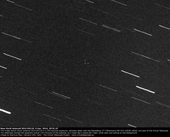
The asteroid 2014 DX110 is seen as a point of light in this image from the Virtual Telescope Project in Ceccano, Italy, captured on March 3, 2014. (Credit: Gianluca Masi)

A newfound asteroid will buzz close by Earth today (March 4), flying safely between our planet and the orbit of the moon, and you can follow the space rock encounter live online.

The asteroid 2014 DX110 will zip by Earth at 4 p.m. EST (2100 GMT) today, just days after its discovery on Feb. 28. NASA officials say it poses no threat to the Earth.

"This asteroid, 2014 DX110, is estimated to be about 100 feet (30 meters) across," officials at NASA's Jet Propulsion Laboratory in California wrote in an alert. "Its closest approach to Earth will be at about 217,000 miles (about 350,000 kilometers) from Earth at about 1 p.m. PST (4 p.m. EST) [2100 GMT] on March 5. The average distance between Earth and its moon is about 239,000 miles (385,000 kilometers)." [Photos: Potentially Dangerous Near-Earth Asteroids]

Two web-based skywatching services, the online Slooh observatory and the Virtual Telescope Project in Italy, will attempt to offer free live views of asteroid 2014 DX110 during its flyby. You can watch both asteroid flyby webcasts on Space.com here, beginning at 3:30 p.m. EST. The webcasts are heavily dependent on weather conditions at the observing sites.

The first asteroid 2014 DX110 webcast at 3:30 p.m. EST comes courtesy of the Virtual Telescope Project overseen by astrophysicist Gianluca Masi in Ceccano, Italy. The webcast will cover the incoming asteroid's approach and closest flyby to Earth during today's space rock encounter.

Masi observed the asteroid Tuesday night by telescope, snapping a photo that revealed the asteroid to be a white pinprick of light in a sea of black space. You can follow Masi's webcast directly at the Virtual Telescope Project website here.

At 4 p.m. EST (2100 GMT), the Slooh observatory will webcast its own coverage of asteroid 2014 DX110 using the company's remote-controlled telescopes. Slooh's Paul Cox will host the observing event.

Slooh officials said it will be a challenge to see asteroid 2014 DX110 because, "with its small size, location, and incredible rate of motion, there is a high probability we will not capture the asteroid during the broadcast."

Today's webcast is one of two asteroid live events in a single week by Slooh. The online skywatching project will host a second webcast on Sunday night (March 9) to track the newfound asteroid 2014 CU13.

Asteroid 2014 DX110 was discovered last week by astronomers using the space rock-hunting Pan-STARRS 1 telescope in Haleakala, Hawaii. The telescope is one of many around the world used to seek out and track near-Earth objects. NASA's Near-Earth Objects program at the Jet Propulsion Laboratory in Pasadena, Calif., oversees one of those efforts.

"NASA detects, tracks and characterizes asteroids and comets using both ground- and space-based telescopes," JPL officials said in a statement. "The Near-Earth Object Observations Program, commonly called 'Spaceguard,' discovers these objects, characterizes a subset of them and identifies their close approaches to determine if any could be potentially hazardous to our planet."

Email Tariq Malik at tmalik@space.com or follow him @tariqjmalik and Google+. Follow us @Spacedotcom, Facebook and Google+. Original article on Space.com.

Copyright 2014 SPACE.com, a TechMediaNetwork company. All rights reserved. This material may not be published, broadcast, rewritten or redistributed.

RELATED ON SKYE: Mind-Blowing New Photos from Space


Permalink | Email this | Linking Blogs | Comments

Are You Prepared for Severe Weather to Strike?

$
0
0
Thursday, March 6, 2014

In this May 20, 2013, file photo, LaTisha Garcia carries her 8-year-old daughter, Jazmin Rodriguez, near Plaza Towers Elementary School after a massive tornado carved its way through Moore, Okla., leaving little of the school and neighborhood. (AP Photo/Sue Ogrocki, File)

With severe weather season upon us, this week is dedicated to the preparations that take place prior to the peak of season, known as National Severe Weather Preparedness Week.

Typically, severe weather ramps up during transitional seasons with severe weather firing up first in the South in February.

March and April are commonly the most active months of the season for the Deep South, while in the northern areas the season's height normally occurs in May and June.

"Severe weather can occur at any time during the year because of the discrepancy between warm, moist air and cold, dry air," AccuWeather Senior Meteorologist Dan Kottlowski said. "The frequency of severe weather is more of a problem headed into the spring months."

Just last year, financial losses from severe weather in 2013 exceeded $1 billion in the United States, according to the National Oceanic and Atmospheric Administration, NOAA.

While the United States averages approximately 1,253 tornadoes per year, according to NOAA, last year ranked below average with 903 tornadoes total.

RELATED:
The Difference Between Tornado Watches and Warnings
AccuWeather Severe Weather Center
WATCH: Erupting Volcano Creates Tornadolike Vortices

Even though numbers were down in 2013, a few disastrous twisters rampaged across Oklahoma, wreaking havoc and destroying entire communities.

Spotlighted last year were two separate tornadoes, the first an EF-5 twister that plundered through Moore, Okla., on May 20, 2013, killing seven children and the second, the widest tornado on record, coming two weeks later on May 31, 2013, barreling through El Reno, Okla.

Still recovering from the aftermath of the deadly twister, Moore continues to rebuild. To help with recovery efforts, the city was awarded $26.3 million in disaster recovery aid by the U.S. Housing and Urban Development. On Feb. 18, 2014, the city plans to release their plan of action publicly.

With this year's severe weather season expected to mimic last year's due to the amount of cold and stable air in the atmosphere, the Gulf Coast may still be at risk for several severe weather incidents, according to AccuWeather.com Lead Long-Range Forecaster Paul Pastelok.

Ahead of the impending season, National Severe Weather Preparedness Week aims to get people ready for the potentially life-threatening dangers of the season, including tornadoes.

To protect yourself and your loved ones from severe weather, NOAA encourages people to know their own risk, take action and be an example in the community.

Aside from taking precautions into your own hands, many companies are joining the fight to ready the nation for the forthcoming season, including AccuWeather.

As a long-time Weather-Ready Nation Ambassador[TM], the company is working hard with NOAA to improve the nation's readiness, responsiveness and overall resilience against extreme weather events.

This program is a recognition that it takes the entire American Weather Enterprise to help people understand their risk for severe and disruptive weather in their community, according to AccuWeather Director of Innovative and Development Jon Porter.
"We will continue communicating, through our public facing digital media properties, information that will help citizens and businesses be aware of upcoming severe weather potential and further understand what impacts can be expected in their area so that they can make improved decisions about how to prepare for dangerous weather," Porter said.

For more information or tips on preparing for severe weather season, visit this website.

RELATED ON SKYE: How to Survive a Hurricane


Read | Permalink | Email this | Linking Blogs | Comments

Spring Fever Alert Issued for Midwest, East in Coming Days

$
0
0
Thursday, March 6, 2014
spring signs
(Getty Images)

Spring will tease the Midwest and East briefly Friday into Saturday and again early next week, thanks to a couple of pushes of milder air.

For some locations around the Great Lakes, the mild air will bring temperatures peaking in the 30s with melting snow and ice.

For locations farther south over the Ohio Valley and along the mid-Atlantic coast, temperatures will climb into the 40s and 50s in many areas.

From the Tennessee Valley to North Carolina and eastern Virginia, temperatures are forecast to make a run into the 60s.

In New England, temperatures will climb into the 30s and even the lower 40s on a couple of days.

While the pattern will not be free of precipitation everywhere and will be interrupted by a push of chilly air mainly on Sunday, the temporary break in the pattern will allow folks to get outdoors. Perhaps open the windows in the house to let in a little fresh air. Joggers and bicyclists will take to the streets, parks and trails.

Now might be the time to see if your car needs attention.

Where there is snow still on the ground, the milder weather will make it easier for novice, less cold hardy people to take to the slopes with their boards and skis.

RELATED:
Photos: Five Signs That Spring is on the Horizon
Six Things to Look Forward to This Spring
Temperature Forecast Maps

Malls, stores and restaurants may notice an uptick in business.

It might even be a good to to check the status of your grill and fire up some hot dogs and burgers.

A few crocuses may emerge from the ground over the next few days across the Ohio Valley and mid-Atlantic. The 2014 National Cherry Blossom Festival in Washington, D.C., will not begin until March 20 and is scheduled through April 13.

Just remember the warm conditions during the day will cause some runoff. Some surfaces made wet by runoff during the day may freeze at night. Use caution with walking, biking or jogging first thing in the morning.

The mild spell may bring another round of potholes, so motorists, bicyclists and pedestrians beware.

The second half of next week may turn unsettled to stormy for a large part of the East and part of the Midwest. Early indications are that a major storm with snow, ice and rain may move up from the Gulf of Mexico.


RELATED ON SKYE: 22 People More Sick of Winter Than You Are


Read | Permalink | Email this | Linking Blogs | Comments

Viewing all 4069 articles
Browse latest View live


Latest Images