Quantcast
Channel: SKYE on AOL
Viewing all 4069 articles
Browse latest View live

Winter Reigns Again as Stormy Pattern Resumes Into March

$
0
0

Tuesday, Feb. 25, 2014
Winter Weather Illinois
(AP Photo/Nam Y. Huh)

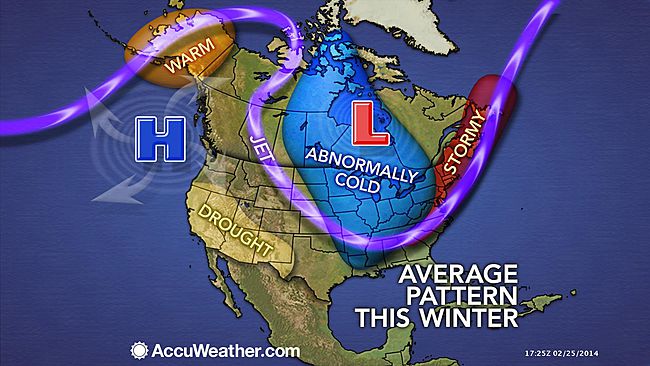
As cold air becomes re-established over the northern half of the nation, multiple storms will continue to move along with rounds of disruptive wintry precipitation.

Over the next couple of weeks, multiple storm tracks will keep the weather pattern rather busy.

One pathway will allow storms to cruise along the Deep South with rounds of showers and thunderstorms.

Clipper storms will also be running about. These moisture-lean storms will drop in from the Canada Prairies and will sweep across the Midwest and Northeast, spreading light, spotty snow.

Stronger storms from the Pacific Ocean will also move eastward across the country, beginning early next week. The stronger storms from the Pacific will bring much-needed rainfall and mountain snow to California and neighboring states.

The storms affecting the eastern two-thirds of the nation during this week are forecast to be on the weaker side of the spectrum. However, they can bring a few rounds of light to moderate snowfall and a wintry mix in the Northern states. These rounds of snow can be enough to cause delays and disruptions to daily activities and travel.

RELATED:
Polar Vortex to Once Again Grip Midwest, Northeast
AccuWeather Winter Weather Center
Nuisance Snow for Northeast Through Midweek

"As a storm moves from the Tennessee Valley to the mid-Atlantic coast, enough cold air may be in place to bring some snow or a wintry mix to the southern Appalachians to parts of northern North Carolina and Virginia Tuesday night," AccuWeather.com Senior Meteorologist Mark Mancuso said.

The same system may bring light to moderate snow over a large part of the mid-Atlantic and New England on Wednesday.

People should expect minor delays from snow or a wintry mix on one or two days along I-80 and I-64 in the north, along I-10 and I-20 in the South from rounds of rain and fog and along I-81 and I-95 that span cold and warm weather precipitation. The system passing through the Northeast on Wednesday will drop a general inch or two of snow with some exceptions.

Meanwhile, most thunderstorms in the South this week will not be severe, but a few storms can be a bit feisty at the local level.

According AccuWeather.com Senior Meteorologist Brett Anderson, "You have to watch the upper-level steering winds. If these winds begin to buckle and the northern and southern branches phase, then a stronger storm may come about that tracks farther north with heavy precipitation."

There is a better chance that the two branches of steering winds phase a bit beginning this coming weekend and next week as the stronger storms from the Pacific Ocean move inland.

"These Pacific storms may bring the potential for more major disruptions," Anderson said, "But the storm track of each will determine which areas get rain versus snow or a wintry mix."

The stronger storm systems this weekend into next week will also bring a greater chance for severe weather in the South.

Ahead of the larger storms, the harshest of the cold in this pattern will be in place.

"There will be record-challenging cold over the Midwest during the second half of the week," Mancuso said.

Temperatures may plunge well below zero in Chicago and Detroit Thursday night.

The cold will continue to settle eastward and southward as this week progresses.

Temperatures could reach zero F late in the week over the interior Northeast.

The lingering cold air and great temperature contrast zone in areas from the central Plains to the Ohio Valley and mid-Atlantic could add extra energy to those larger storms as they move along this weekend into next week.

RELATED ON SKYE: 30 Ice Sculptures That Will Take Your Breath Away


Read | Permalink | Email this | Linking Blogs | Comments


Harsh Winter Weather Confines Consumers, Employees

$
0
0
Tuesday, Feb. 25, 2014
US-WEATHER-SNOW
(TIMOTHY CLARY/AFP/Getty Images)

Adjusted for seasonal variations, U.S. retail and food sales figures dropped by 0.4 percent January from December 2013, according to the Department of Commerce Census Bureau's monthly report - 2014's severe winter weather may be a major contributing factor, according to some economists.

National Retail Federation chief economist Jack Kleinhenz said the harsh winter weather is masking economic performance due to extreme temperatures causing slowdown in retail sales, according to an NRF statement.

"Following a solid holiday sales season, it seems that many consumers decided to take a break from the stores and shopping malls this January in an attempt to avoid winter weather," NRF President and CEO Matthew Shay said in the statement.

Commerce department spokesman Thomas Dail said that weather can have an economic impact in several ways.

"One aspect is that we do sometimes see weather affecting household purchases of energy," Dail said, adding there may be decreases in spending elsewhere.

"Our data is seasonably adjusted," he said. We do not have (fiscal quarter one) 2014 data yet."

The commerce department will release their reports in March.

Retail sales figures are a major component of how the department calculates consumer spending statistics as part of the overall gross domestic product, Dail said.

"Retail sales are a large part of GDP," he said. "They're an important part of that."

In addition to keeping consumers indoors, severe weather also results in temporary absences from school and work for many Americans, Bureau of Labor Statistics Spokeswoman Mary Bowler said.

By monitoring recent historic weather events and combining the bureau's survey data, Bowler was able to tabulate statistics on absent workers.

"It was more or less a 50-50 of people who were absent that got paid," she said, referring to severe winter weather events in 2010.

In February 2010, approximately 5,344,000 full-time employees working in non-agricultural industries were absent because of severe winter weather. In January 2011, approximately 4,857,000 full-time employees were absent.

According to AccuWeather Meteorologist Brian Edwards, record-breaking snowfalls affected many of the major metropolitan areas in the Northeast during those months.

RELATED:
State Budgets Continue to Take Winter Beating; Salt Sails to New Jersey
AccuWeather Winter Weather Center
Could Virtual Classrooms Be a Solution for Snow Days?

New York City was slammed with 36.9 inches of snow in February 2010 and 36 inches of snow in January 2011.

"For that month in New York City, it was the snowiest January on record," he said, adding that February 2010 also holds the record for most snowfall for that month.

Weather data for the city stretches as far back as 1875. Philadelphia was hit with 51.5 inches of snow in a single month in February of 2010, followed by Baltimore, which received approximately 50 inches.

Edwards said snowfall of that magnitude is extremely rare.

"When you look at the average for that month, the average for New York City is seven inches of snow," he said.

Bowler said she could not create an accurate average of how much was lost in total wages during those years because of weather-related absences, but said that when looking at the survey data, only about half of the full-time employees received pay.

"We can't effectively tabulate a total pay loss," she said, adding that some economists may try to create averages based on median incomes.

RELATED ON SKYE: The World's Most Pathetic Snowmen


Read | Permalink | Email this | Linking Blogs | Comments

Frigid Air, Nuisance Snow for DC, NYC and Boston

$
0
0

Tuesday, Feb. 25, 2014
New York City Hit With More Snow
(Photo by Andrew Burton/Getty Images)

Frigid arctic air looks to make a return to the Northeast and Midwest this week following some of the warmest weather the regions have had so far this year, but the colder weather will not return alone.

A series of quick-hitting disturbances and lake-effect snow events will spread a bit of snow across the Midwest and Northeast on a couple of occasions through Tuesday.

However, it is the pair of storms--one set to move through the Midwest, the other across the South--following for Wednesday that will bring the greatest chance for accumulating snowfall to the Northeast.

It appears though that the storms will remain separate until reaching Atlantic Canada, resulting in accumulations on the lighter side across the Northeast.

With cold air locked in place, just an inch of snow can lead to slick spots on roadways around cities such as Columbus and Pittsburgh; particularly during the Tuesday morning commute.

The greatest chance for a steadier snow in the Northeast will arrive on Wednesday as low pressure develops just off the East Coast.

This system is now expected to track farther away from the coast than previously thought, but will still be close enough to bring a light accumulating snowfall to the Northeast.

Although this system is not forecast to bring heavy accumulations to the I-95 corridor, it may still lead to minor traffic delays.

This includes the possibility of flight delays and cancellations in cities such as New York City, Washington, D.C., Philadelphia and Boston.

RELATED:
Polar Vortex to Make Encore Performance in Midwest, Northeast
AccuWeather.com Winter Weather Center
More Big Snow in the Northeast, Fresh Powder for Colorado and Northwest

While folks along the East Coast will be tracking the midweek snow, all residents from the Midwest to Northeast will experience waves of colder air this week as the polar vortex sinks southward.

Since the cold air will hold firm through the start of March, the Northeast could become the target of one or two more snowstorms during that time.

RELATED ON SKYE: 22 People More Sick of Winter Than You Are


Permalink | Email this | Linking Blogs | Comments

Rain Finally Back in the Forecast for California

$
0
0
Tuesday, Feb. 25, 2014
Much Needed Rain Falls In Bay Area, As State Continues To Suffer Worsening Drought
(Photo by Justin Sullivan/Getty Images)

The second half of this week will feature soaking rain and mountain snow returning to drought-stricken California.

Confidence is growing for California to soon receive a substantial amount of rain and mountain snow from two storm systems.

The first system is scheduled to move through California Wednesday through Thursday with the second to follow for Friday through the first part of the the weekend.

The second is likely to be the stronger and wetter of the two systems, bringing a much-needed soaking to many communities (with the deserts being the exception).

If the first storm bypasses or only grazes Southern California, the second will not. It is possible thatDowntown Los Angeles receives at least half of the rain that fell in all of 2013 (3.60 inches) from this one storm Friday through next weekend.

Several inches of rain could soak the northern California coast, while feet of snow may blanket the Sierra. Snow levels could drop low enough to whiten the mountains of Southern California.

More details and precise rain/mountain snowfall amounts will become clearer in the upcoming days.

The upcoming rain and mountain snow will definitely be welcome to a state where the percentage area of places enduring an extreme to exceptional drought was 68 percent on Feb. 18, the U.S. Drought Monitor stated in its latest report.

The number was nearly 61 percent the week prior.

California's Department of Water Resources states that the amount of water stored in the snowpack across the Sierra was only 25 percent of normal on Friday.

As this snow in the Sierra melts during the warmer months, the runoff helps fill reservoirs downstream.

RELATED:
Latest Weather-Related Watches, Warnings
Southwest Regional Interactive Radar
Every State May Feel the Effects of Historic California Drought


While many residents are likely rejoicing at the news of the returning wet weather, some hazards will also accompany the storms.

Enough rain could fall to trigger flash flooding and mudslides in areas recently burned by wildfires.

At the rain's onset, roads will turn slick as the rain mixes with oil residue left behind by vehicles during the prolonged dry spell.

Motorists could face treacherous travel and chain restrictions in the mountains, including on I-80's Donner Summit. Flight delays may impact airline passengers.

The second storm could also trigger severe thunderstorms.

Before the rainy second half to next week, dry and mild conditions will prevail through Tuesday. Morning low clouds and fog, however, will limit the amount of warming along the coast.


RELATED ON SKYE: 50 Must-See Weather Photos
Lightning Hits the Grand Canyon


Permalink | Email this | Linking Blogs | Comments

Watch: Sun Unleashes Monster Solar Flare, Biggest of 2014

$
0
0


The sun fired off a major solar flare late Monday (Feb. 24), making it the most powerful sun eruption of the year so far and one of the strongest in recent years.

The massive X4.9-class solar flare erupted from an active sunspot, called AR1990, at 7:49 p.m. EST (0049 Feb. 25 GMT). NASA's Solar Dynamics Observatory captured high-definition video of the monster solar flare. The spacecraft recording amazing views the solar flare erupting with a giant burst of plasma, called a coronal mass ejection, or CME.

Solar Flare
NASA/SDO

Earth isn't in danger from the latest eruption of space weather activity, according to officials with Spaceweather.com, which tracks space weather and stargazing events. Sunspot AR1990 (previously named AR1967) is located on the southeastern limb of the sun, pointed away from Earth. This is the third time this sunspot has rotated onto the Earth-facing side of the sun. [Photos: The Biggest Solar Flares of 2014]

"Long-lived sunspot AR1967 returned to the Earthside of the sun on Feb. 25th and promptly erupted, producing an X4.9-class solar flare," astronomer Tony Phillips wrote in a Spaceweather.com alert. "This is the strongest flare of the year so far and one of the strongest of the current solar cycle."

Earth isn't totally out of the woods yet, however. This region of the sun is set to rotate more fully into view of Earth over the next week, according to officials with the NOAA-led Space Weather Prediction Center.

X-class solar flares are the most powerful kinds of solar storms. If directed at Earth, last night's solar flare could have caused a serious geomagnetic storm, created when charged particles slam into the planet's magnetic field. When aimed at Earth, strong solar flares can harm satellites and astronauts in orbit around Earth. A powerful solar flare delayed the launch of a private cargo ship to the International Space Station in January.

"Radio emissions from shock waves at the leading edge of the CME suggest an expansion velocity near 2,000 km/s or 4.4 million mph," Phillips wrote. "If such a fast-moving cloud did strike Earth, the resulting geomagnetic storms could be severe."

The sun is currently in the active phase of its 11-year solar cycle, called Solar Cycle 24. While X-class storms are the most powerful, mid-level flares are named M-class events, which can supercharge Earth's northern lights. Weaker C-class events round out the top three most powerful types of solar storms.

Follow Miriam Kramer @mirikramer and Google+. Follow us @Spacedotcom, Facebook and Google+. Original article on Space.com.

Copyright 2014 SPACE.com, a TechMediaNetwork company. All rights reserved. This material may not be published, broadcast, rewritten or redistributed.


Permalink | Email this | Linking Blogs | Comments

PHOTOS: 'Bizarre Beautiful' Clouds Hover Over Atlanta, Resemble a Roller Coaster

$
0
0

Tuesday, Feb. 25, 2014

Jeremy Campbell captured this view of the Atlanta skyline early Tuesday, Feb. 25, 2014, saying the clouds look like a roller coaster track. (Twitter Photo/@Jeremy11alive).

Commuters stuck in traffic were busy snapping pictures of choppy, wavelike clouds that were suspended over the Atlanta skyline early Tuesday morning.

Share this on Facebook?

The clouds, referred to as asperatus clouds by meteorologists, are sometimes very ominous in appearance, but they do not necessarily indicate stormy weather.

RELATED:
Survival Guide: Recognizing Which Clouds Mean Danger
Blog: A New Cloud for My Birthday
Share Your Photos on AccuWeather.com's Facebook Page

"Asperatus clouds form on the outside of precipitation areas, where the rain attempts to invade dry air," AccuWeather.com Meteorologist and Social Media Coordinator Jesse Ferrell said.

Only a trace of rain fell in Atlanta early Tuesday as rain approached the area and ran into dry air blanketing Georgia.


Jeremy Campbell captured another shot of the clouds in Atlanta on Tuesday, Feb. 25, 2014. (Twitter Photo/@Jeremy11alive)


"Bizarre beautiful" clouds over Atlanta on Tuesday morning, Feb. 25, 2014, captured by Jarno Kettunen (Twitter Photo/@jarnotweets).


John S. captured the clouds over Atlanta while stuck in traffic on Tuesday, Feb. 25, 2014. (Twitter Photo/@ohiobigcat).


Jen took this picture of clouds over Atlanta on Tuesday, Feb. 25, 2014. (Twitter Photo/@mockingnerd).


Danny Hughes took this picture of the asperatus clouds over Atlanta on Tuesday, Feb. 25, 2014. (Twitter Photo/@MockingBirdDan).


Sean tweeted this picture of the sky of over Atlanta on Tuesday, Feb. 25, 2014. (Twitter Photo/@seanenslin).


RELATED ON SKYE: 13 Clouds to See in Your Lifetime
Lenticular Clouds


Read | Permalink | Email this | Linking Blogs | Comments

Rough Winter to Lag Into March for Midwest, East

$
0
0

Wednesday, Feb. 26, 2014
Winter Weather
(AP Photo/Michael Dwyer)

While spring officially begins on March 20 and there are signs of a pattern change beginning around that date, winter may not be in a hurry to let go over much of the Central and Eastern states completely.

March is typically a battle of two seasons: winter and spring. While there are indications of an end to the intrusions from the polar vortex and corresponding freezing and subzero weather during the month ahead for many areas of the Midwest and East, this may be a slow spring.

According to Paul Pastelok, head of AccuWeather's Long Range Team, "The pattern causing the persistent cold will not suddenly go away and stay away in the weeks ahead."

Pastelok and crew expect mid-winter style cold to continue more often than not until the third week in March for most areas east of the Rockies.

"Beginning around the third week of March and continuing through much of April in the Midwest and East, the pattern will transition to more of a chilly spring weather pattern," Pastelok said.

The slow spring transition will be complicated by rather wet and stormy weather at times in the Midwest, East and especially the South.

Surges of warmth over the interior South and East, while possibly dramatic over short distances, are likely to be punctuated.

"We just do not see a sudden snap in winter or any long-duration warm, dry weather coming up for most Central and Eastern states until late in the spring," Pastelok said.

Pastelok stated that it may take until late April or May for steady warmth be widespread in the East.

The sputtering warmup could ease concerns for a sudden meltdown and widespread major flooding in the northern tier states. However, the overall chilly wet pattern could lead to some frustration for people with outdoor activities and pothole-dodging motorists. There are some concerns for flooding moving forward into the spring for parts of the interior South to the Midwest.

Why Has It Been so Cold in the Midwest, East?

Steering winds high in the atmosphere, known as the jet stream, have been in a very high amplitude configuration for months.

Early in the winter, the pattern developed big southward dip in much of eastern North America and a northward bulge in western North America.

Since Dec. 1, 2013, Minneapolis has averaged 8 degrees below normal with Chicago at 7 degrees below normal and Detroit 6.5 degrees colder than average.

The persistent cold, accompanied by snow and ice at times, has busted budgets for states, cities and townships and caused tens of thousands of flight cancelations nationally. The extreme winter will force many school districts to alter their spring schedules to make up for lost school days.

Winter Has Not Been Cold Everywhere

According to AccuWeather.com Senior Meteorologist Brett Anderson, "Despite the cold winter over eastern North America and much of Russia, it was business as usual for much of the globe over the past few months."

Bulges in the jet stream have created well-above average warmth not only in western North America, but also in much of China, Greenland and to some extent western and southern Europe.

According to the National Climatic Data Center (NCDC), January was the second warmest on record in China and the third warmest in Alaska. Records have been kept since 1961 and 1918, respectively.

RELATED:
Nuisance Snow for DC, NYC and Boston
AccuWeather Winter Weather Center
Winter Reigns Again as Stormy Pattern Resumes Into March

"Both December 2013 and January 2014 ranked in the top five warmest globally, while 2013 tied for fourth warmest year on record," Anderson said.

Global surface temperature records date back to 1880.

"Nine of the 10 warmest years on record have occurred during the 21st century and only one year, 1998, was warmer than 2013," Anderson said.

January Arctic sea ice extent was below the 30-year average compiled from 1981 to 2010.

In contrast, January Antarctic sea ice extent was the second largest for the 30-year average compiled from 1981 to 2010. So far this winter, the extent of Great Lakes ice is the third largest since records began in the late 1970s.

RELATED ON SKYE: 22 People More Sick of Winter Than You Are


Permalink | Email this | Linking Blogs | Comments

Nuisance Snow Arrives for DC, NYC and Boston Wednesday

$
0
0

Wednesday, Feb. 26, 2014
Winter Weather
A member of the National Park Service spreads salt on a sidewalk leading to the White House in Washington, Wednesday, Feb. 26, 2014, as snow falls. (AP Photo/Carolyn Kaster)

Frigid arctic air will return to the Northeast and Midwest this week, but the colder weather will not return alone. Slippery rounds of snow are in store.

A pair of storms--one set to move through the Midwest, the other across the South--on Wednesday is bringing the greatest chance for accumulating snowfall to the Northeast.

It appears though that the storms will remain separate until reaching Atlantic Canada, resulting in accumulations on the lighter side across the Northeast.

The steadier, more widespread snow in the Northeast will arrive on Wednesday as low pressure develops just off the East Coast.

This system is now expected to track farther off the coast than previously thought, but will still be close enough to bring a light accumulating snowfall to the Northeast.

RELATED:
Rough Winter to Lag Into March for Midwest, East
AccuWeather.com Winter Weather Center
More Big Snow in the Northeast, Fresh Powder for Colorado and Northwest

Although this system is not forecast to bring heavy accumulations to the I-95 corridor, it may still lead to minor travel delays.

This includes the possibility of flight delays and cancellations in cities such as New York City, Washington, D.C., Philadelphia and Boston.

While folks along the East Coast will be tracking the midweek snow, all residents from the Midwest to Northeast will experience waves of colder air this week as the polar vortex sinks southward.

Since the cold air will hold firm through the start of March, the Northeast could become the target of one or two more snowstorms during that time.

RELATED ON SKYE: The 10 Snowiest Places on Earth


Permalink | Email this | Linking Blogs | Comments


Avalanche Deaths Spike as Storms Bring Snow, Risks

$
0
0
Wednesday, Feb. 26, 2014
In this Feb. 21, 2014 photo, Colorado Department of Transportation employees stop traffic as they use an explosives launcher to try to trigger a controlled avalanche, near Empire, Colo. Lots of new snow and strong winds in the past month have fueled dangerous conditions from the Cascades to the Rockies, prompting forecasters to issue warnings of considerable or high avalanche dangers for many areas outside of established ski areas. (AP Photo/Brennan Linsley)
In this Feb. 21, 2014 photo, Colorado Department of Transportation employees stop traffic as they use an explosives launcher to try to trigger a controlled avalanche, near Empire, Colo. (AP Photo/Brennan Linsley)

SEATTLE (AP) - Skiers and snowboarders rejoiced when a series of storms dumped several feet of snow in the mountains across the West, after what had been a disappointing start for those seeking fresh powder in the backcountry.

But all the new snow and strong winds in the past month have fueled dangerous conditions from the Cascades to the Rockies, prompting forecasters to issue warnings of considerable or high avalanche danger for many places outside of established ski areas.

Seventeen people have died in an avalanche this winter, 11 of them since early February. Many more skirted disaster and survived with broken bones or other injuries. Some were partially buried in snow, but managed to dig themselves out or were dug out by companions.

Avalanche experts are seeing a similar problem across the region: too much snow and strong winds overloading weak layers of old snow. With too much stress and not enough time to bond or stabilize, that weak snow layer eventually gives way.

"It's like putting a brick on top of a pile of potato chips," said Bruce Tremper, director of the U.S. Forest Service's Utah Avalanche Center.

Some parts of Utah received more snow in the past three weeks than in the prior three months, he said last week.

The latest death, last weekend, came when a 49-year-old man was buried by a slide while snowmobiling in the West Cabinet Range near the Idaho-Montana border. His friend was buried with only his face exposed, but was dug out with no injuries, according to the Flathead Avalanche Center, which rated the slide forceful enough that it could destroy a car. The avalanche danger the day before, the last time conditions were updated, was high.

That same day in the Whitefish range in western Montana, three other snowmobilers escaped injury in two separate incidents when slides swept them down the slope.

Avalanches have killed on average about 28 people a year over the past 10 years, according to the Colorado Avalanche Information Center in Boulder, which tracks national statistics. The deaths so far this year aren't unusually high, experts say, but have come during a short time period.

What has been unusual is how large and intense the slides have been.

According to the Colorado Avalanche Information Center, several recent avalanches ran larger than any in the past 20 years.

Scott Toepfer, an avalanche forecaster, said the large and destructive slides have taken out century-old trees and ripped off its foundation an old mining structure that has stood for decades.

"It's been storm after storm after storm, and that foundation has reached a tipping point," Toepfer said last week.

With more people venturing into the backcountry to play, experts say it's more likely that people will be hurt or killed. They advise recreationists, at the very least, to get proper avalanche education, carry the right equipment including a beacon, shovel and probe, and check mountain and avalanche forecasts before heading out.

The Northwest Avalanche Center in Seattle offers hundreds of free avalanche awareness classes each winter. Lately, program director Scott Schell and others are targeting younger audiences, giving talks about avalanche safety at middle schools, ski schools and Boy Scout troops.

"We're trying to get to them young enough to give them basic skills to make better decisions on their own," Schell said.

Toepfer said that even the right equipment and education won't make people immune to slides.

"Be judicious, be conservative in decision-making, and really evaluate the consequences of making the wrong decisions," Toepfer said. "If you're uncertain at all, the best thing to do is to back off."

Boulder retiree Fred Larke, who recently went backcountry skiing near Winter Park, Colo., makes sure he heads into the backcountry with a friend, an avalanche beacon and a slope meter that helps him stay aware of steep slopes that are prone to avalanches.

"In reality, the best way to survive an avalanche is not to get caught in it in the first place," he said.


RELATED ON SKYE: 20 Photos of Monster Blizzards


Permalink | Email this | Linking Blogs | Comments

NASA Turns Research to California Drought

$
0
0
Wednesday, Feb. 26, 2014
File - In this Oct. 2, 2009, file photo, a dead almond crop is seen in California's Westland Water District in Fresno, Calif. NASA scientists have begun deploying satellites and other advanced technology to help California water officials assess the state's record drought and better manage it, officials said Tuesday, Feb. 25, 2014. California's relationship with NASA began shortly after the dry year of 2009, when officials sought answers to problems exacerbated by the lack of rain and snow, such as the sinking land. (AP Photo/Russel A. Daniels, File)
A dead almond crop is seen in California's Westland Water District in Fresno, Calif. (AP Photo/Russel A. Daniels, File)

FRESNO, California (AP) - NASA scientists have begun deploying satellites and other advanced technology to help California water officials assess the state's record drought and better manage it, officials said Tuesday.

The California Department of Water Resources has partnered with NASA to use the space agency's satellite data and other airborne technology to better measure the snowpack, groundwater levels and predict storms.

"It sounds like a cliche, but if they could put a man on the moon, why can't we get better seasonal forecasting?" Jeanine Jones of the state's Department of Water Resources said in an interview following the Sacramento announcement of the partnership.

Now they will. NASA scientists said they are also embarking on projects that use satellite images to help more accurately measure the number of fields farmers have chosen not to plant and where land is sinking because of excessive ground-water pumping.

Gov. Jerry Brown directed state officials to form such partnerships as part of his drought emergency declaration last month.

California's relationship with NASA began shortly after the dry year of 2009, when officials sought answers to problems exacerbated by the lack of rain and snow, such as the sinking land. This year's drought has made that research all more important, Jones said, adding that the preliminary findings proved that there's plenty more to learn.

NASA geologist Tom Farr said that bringing together all types of research and modern technology like pieces of a puzzle may help those in charge of managing the state's water supply avoid deficit water years like this.

"We're on the verge of being able to put all these measurements together and start looking at the concept of closing the water budget of California," he said.

Lawrence Friedl, director of NASA's Applied Sciences Program, said that 13 of the agency's satellites are focused on water. Three more water research projects are scheduled by NASA, including a satellite to be launched Feb. 27 with the Japan Aerospace Exploration Agency.

Projects NASA is advancing include measuring so-called "atmospheric rivers" to better predict global storm systems farther in advance so rain can be captured in California reservoirs. Satellite images that show the amount of land farmers have chosen not to plant in a drought will arm officials in Sacramento with information about where to open food banks for farm workers.

Satellites technology will help officials identify levees that are prone to break with high volumes of water, scientists said.

RELATED ON SKYE: 7 Surprising Health Effects of Drought


Permalink | Email this | Linking Blogs | Comments

Dangerous Cold to Grip Midwest Late This Week

$
0
0
Wednesday, Feb. 26, 2014
Deep Freeze
Commuters exit Union Station with wind chills nearing minus 30 Fahrenheit on Tuesday, Jan. 7, 2014, in downtown Chicago. (AP Photo/Andrew A. Nelles)

Arctic air will shift into the Midwest, bringing temperatures as much as 30 degrees below average into the weekend. Temperatures will fall low enough to challenge records late this week.

Some major cities, such as Minneapolis, were already experiencing very cold air on Tuesday, as the high only reached 6 F.

The core of the cold air will stay in the northern tier of the country, spanning cities such as Green Bay, Chicago, Fargo and Traverse City.

Temperatures will bottom out in Minneapolis on Thursday with the high only reaching minus 4 F. Lows Wednesday night and Thursday night will be in the negative teens with wind making it feel even colder.

Average high temperatures for the end of February in Minneapolis are in the lower 30s, with average lows near 18 F.

Chicago will also endure colder air to end the week. Highs on Thursday will be kept in the single digits with the low plummeting near minus 10 F. With wind factored in, AccuWeather RealFeel(R) temperatures will be as low as minus 35 F.

RELATED:
Winter Reigns Again as Stormy Pattern Resumes
AccuWeather.com Winter Weather Center
Rough Winter to Lag Into March for Midwest, East

Cold of this caliber is dangerous, and residents are urged to bundle up and cover their skin. Being outside with exposed skin for only a short duration in this level of cold can lead to frostbite.

In addition to the cold, a more active weather pattern will set in to end the winter. AccuWeather.com Senior Meteorologist Alex Sosnowski explained that the moist jet from the Pacific and Polar jet will bring more frequent, stronger storms.

The cold will continue to shift south and east into next week.


Permalink | Email this | Linking Blogs | Comments

Hubble Zooms in on Historic Supernova SN 2014J

$
0
0

Feb. 26, 2014

On Jan. 21, astronomers spotted the closest supernova in recent decades flash to life in the galaxy M82, some 11.5 million light-years from Earth. The supernova, designated SN 2014J, suddenly became a superstar as it became so bright that amateur astronomers with modest telescopes could easily pick out the stellar explosion in the night sky. Now, Hubble has slewed in the direction of M82 to snap this dreamy portrait of the historic stellar event.

PHOTOS: Hubble's Latest Mind Blowing Cosmic Pictures

SN 2014J is known as a Type 1a supernova, a very special kind of supernova. It is thought a Type 1a supernova is triggered by a white dwarf - an ancient small star that is the stellar husk of a star of approximately the same mass as our sun - accumulating material from a binary partner star. When the accumulated mass reaches a certain threshold, the bloated white dwarf ignites a supernova. As the threshold of material is very specific, which generates a very specific quantity of energy, Type 1a supernovae are used by astronomers as "standard candles" to measure the scale of the Universe. If you know the amount of energy released by this supernova, no matter where it is in the Cosmos, you can precisely measure your distance from it.

In the case of SN 2014J, the closest Type 1a supernova since SN 1972e, this is the perfect opportunity to further understand the mechanisms behind a phenomena that underpins our ability to understand the scale, age and expansion of the Universe. In 1998, astronomers made the groundbreaking discovery that a mysterious force was acting on the expansion of the Universe, dubbed "dark energy," and Type 1a supernovae were at the root of this revelation.

PHOTOS: Hubble's Sexiest Spiral Galaxies

In this new observation captured by Hubble's Wide Field Camera 3, the supernova has been superimposed over a photo mosaic of the entire M82 galaxy in 2006 taken with Hubble's Advanced Camera for Surveys. This supernova portrait was acquired on Jan. 31, just as the explosion was reaching its peak in brightness.

As Hubble is sensitive to ultraviolet wavelengths of light, the impact of the supernova on the surrounding interstellar environment can be studied, building on our knowledge of these important stellar events and how they can impact their host galaxies.

RELATED ON SKYE: 25 Dazzling Images from the Hubble Telescope
Horsehead Nebula Hubble Telescope


Permalink | Email this | Linking Blogs | Comments

20 Real Photos That Look Like Scenes From the Apocalypse

Long-Duration, Disruptive Snow Awaits Midwest, East

$
0
0
Thursday, Feb. 27, 2014
Winter Weather
(AP Photo/Matt Rourke)

March may not come in like a lion everywhere across the nation, but winter will roar during the first several days of the month and impact more than 100 million people.

Early indications are that a long-duration snow event will expand from the northern Rockies and central Plains to portions of the Midwest and Northeast in the days ahead.

The adverse winter conditions will develop Friday into Saturday over the Central states and is forecast to shift slowly eastward Sunday and Monday.

People traveling by road or airways should expect major delays as this area of snow expands eastward and crawls along. While some gaps are likely during the storm, snow or a wintry mix could fall for 36 hours straight or more in some areas.

For a time, the snow will impact areas between the I-70 and I-90 corridors over the Rockies and Plains and the I-64 to I-80 corridors in the Midwest and East. The west to east area of snow may be falling over a distance of 1,500 miles.

Major airport hubs from Chicago, St. Louis, Detroit, Cincinnati, Pittsburgh, Washington, D.C., Philadelphia, New York City and Boston may all be affected by the storm.

RELATED:
Rough Winter to Lag Well Into March for Midwest, East
Heaviest Rain in Months Heading to Southern California
AccuWeather Winter Weather Center

Initially, the storm will evolve into a blizzard over the northern Rockies and northern High Plains with dangerously low AccuWeather RealFeel(R) temperatures.

Farther east, the storm may be less intense in terms of wind and low RealFeel extremes, but precipitation can be quite heavy and very disruptive. The storm is likely to impact not only travel, but also school and business activities. The storm may completely tap remaining ice-melting supplies in some communities.


This graphic is but a snapshot of the storm for Sunday into Sunday night. The snow and ice area will migrate southward and northward over time through Monday.

According to AccuWeather Chief Meteorologist Elliot Abrams, "The challenge with this storm is figuring out where the north-south boundary between rain and snow will set up and migrate to as the storm progresses slowly eastward."

At this early stage, the storm has the potential to bring half of a foot to a foot of heavy wet snow to some locations in the Midwest and East, with locally higher amounts. Ice is a concern for some areas as well.

"In a narrow swath, all or part of the storm will deliver snow that may be difficult to shovel and plow, due to its accumulation and weight," Abrams said. "While many areas will be impacted by the storm in the Midwest and East, we are not sure which areas will get hit the hardest with snow and ice just yet."

A tremendous temperature contrast will set up from north to south with the storm. A distance of 100 miles could bring temperatures ranging from the 60s and 70s to the 20s and 30s.

In the warm air on the southern flank of the storm, drenching rain and thunderstorms will occur. Long-duration rainfall will occur near the rain/snow line, while the potential for strong to locally severe thunderstorms is greatest over the lower Mississippi Valley.

Details will continue to unfold over the next few days on the storm as to which areas are mostly likely to receive all snow or a change from snow to rain and vice versa.

RELATED ON SKYE: 20 Photos of Monster Blizzards


Read | Permalink | Email this | Linking Blogs | Comments

Wind-Driven Snow to Hit Northern Rockies, Central Plains

$
0
0

Thursday, Feb. 27, 2014
Winter Storm Midwest
(AP Photo/Craig Lassig)

March will come in like a lion from a large part of Montana, Wyoming, Nebraska and Iowa to parts of Idaho, Colorado, Utah and the Dakotas, due to a long-duration snow event.

Late this week and into this weekend, as another batch of Arctic air pushes southward, storms from California will roll northeastward and unleash wind-driven snow and dangerously low AccuWeather RealFeel(R) temperatures.

The snow will begin Thursday night over the northern and central Rockies and will expand eastward Friday and Saturday across the High Plains, while continuing over some of the mountain ranges.

The long-duration snow event has the potential to drop a couple of feet of snow over the high country in Montana, Wyoming, Idaho and Utah. Enough snow can fall with gusty winds to hinder or halt travel through the passes along I-80 and I-90.

Farther east over the Plains, centering along the I-80 corridor, the snow is not likely to be heavy in most areas but will still be disruptive, factoring in wind, and dangerous, considering temperatures. At times, the adverse conditions can reach as far south as I-70 and as far north as I-90.

RELATED:
Dangerous Cold to Grip North Central States Through This Weekend
Heaviest Rain in Months Heading to Southern California
AccuWeather Winter Weather Center

Even though the storm may fall short of blizzard conditions in most locations, at times the snow will be wind-driven and will produce poor visibility.

Temperatures will range from the single digits to below zero with much lower RealFeel levels at the height of the storm over the weekend in Billings, Mont.; Casper, Wyo.; Rapid City, S.D.; Omaha, Neb.; and Des Moines, Iowa.

Snow and a wintry mix will will extend farther south over northern Kansas and northern Missouri.

Some snow will affect Denver later in the weekend with less extreme temperatures, but the potential for travel delays will exist.

Most of the snow will slide south of Minneapolis, but very low temperatures and RealFeels will be a major factor in this weekend's weather.

People in or traveling through Chicago should anticipate significant delays and disruptions due to snow.

Close to the Mississippi River and areas farther east in the Midwest and Northeast, snowfall will again ramp up as the storm taps into moisture from the Gulf of Mexico and the Atlantic Ocean.

While skiers and boarders will relish the snowstorm over the mountains in the West, the heavy amount of snow and fluctuating temperatures will raise concerns for avalanches into next week.


RELATED ON SKYE: 20 Photos of Monster Blizzards


Read | Permalink | Email this | Linking Blogs | Comments


Heavy Rain, Mountain Snow to Aid California Drought

$
0
0

Thursday, Feb. 27, 2014
California Storms
Jose Ortega, left and Fidel Meza work the soil looking for drip lines in a dry tomato field as storms arrive in the area Wednesday, Feb. 26, 2014 in Lemoore, Calif. (AP Photo/Gary Kazanjian)

Another round of rain is headed for California before the end of the week, bringing further relief from the extreme drought gripping much of the Golden State.

This rain is forecast to move in on Friday, right on the heels of the storm that brought rain to parts of the state on Wednesday. This second storm will have some differences though, including a heavier rain that will span across the entire state.

As beneficial as this rain will be, it does pose some dangers, particularly to those living in Southern California.

According to AccuWeather.com Western Weather Expert Ken Clark, "Rain will fall everywhere in the state Friday and Friday night with the heavy rain mostly in the southern third of the state."

This is a big difference from that storm that affected the state Wednesday into Thursday, as some residents of Southern California did not even see a drop of rain.

Not only will the rain help battle the drought, but heavy snow is expected to fall in the mountains with several feet possible in the Sierra through Saturday. This snow is crucial during the warmer months when the runoff helps to fill water reservoirs downstream.

RELATED:
Ken Clark's Western U.S. Weather Blog
Drought-Stricken Southwest Tears up Lawns to Save Water
California Interactive Radar

Several inches of rain are likely through Saturday along the California coast with the heaviest rain focusing along the coast of Southern California.

"I would expect to see some amounts in the 6- to 8-inch range Friday into Saturday in the mountains with 4 to 6 inches in the spots in the lower foothills. This would include the recent burn area around the San Gabriel Valley." Clark said.

Periods of heavy rain are also in store for southern parts of Nevada and Utah as well as northern Arizona as the moisture associated with the storm travels inland.

This rain does bring some hazards with it, however. Heavy rain can quickly lead to flash floods or even mudslides, especially in areas that have been affected by wildfires over the past several months.

Folks living in these areas are encouraged to have a plan in place in the event that you must leave your home with little warning.

Thunderstorms will also develop over Southern California on Saturday, bringing the risk of damaging winds and hail. A brief tornado or waterspout cannot be ruled out either.

So far this year, San Diego has only received measurable precipitation on three days totaling 0.36 of an inch. This equates to only 9 percent of what the city normally receives up to this point in the year.

According to the U.S. Drought Monitor report on Feb. 18, 2014, more than 90 percent of California was under a severe drought, and 68 percent under an extreme drought.

Although the rainfall through the weekend will help to lower these percentages, it will take much more rain to have a long-term impact on the current drought.

The chance of rain will return again to California during the first half of next week; however, most of this rain appears like it will stay mainly over the northern half of the state.


RELATED ON SKYE: 7 Surprising Health Effects of Drought


Read | Permalink | Email this | Linking Blogs | Comments

NASA Announces 'Mother Lode' of 715 New Planets

$
0
0
Thursday, Feb. 27, 2014
This handout artist conception provided by NASA depicts multiple-transiting planet systems, which are stars with more than one planet. The planets eclipse or transit their host star from the vantage point of the observer. This angle is called edge-on. Our galaxy is looking far more crowded as NASA Wednesday confirmed a bonanza of 715 newly discovered planets circling stars other than our sun. Four of those new planets are in the habitable zones where it is not too hot or not cold. NASAís Kepler planet-hunting telescope nearly doubled the number of planets scientists have discovered in the galaxy, pushing the figure to about 1,700. Twenty years ago, astronomers had not found any planets outside our solar system. (AP Photo/NASA)
This handout artist conception provided by NASA depicts multiple-transiting planet systems, which are stars with more than one planet. (AP Photo/NASA)

WASHINGTON (AP) - Our galaxy is looking far more crowded and hospitable. NASA on Wednesday confirmed a bonanza of 715 newly discovered planets outside our solar system.

Scientists using the planet-hunting Kepler telescope pushed the number of planets discovered in the galaxy to about 1,700. Twenty years ago, astronomers had not found any planets circling stars other than the ones revolving around our sun.

"We almost doubled just today the number of planets known to humanity," NASA planetary scientist Jack Lissauer said in a Wednesday teleconference, calling it "the big mother lode."

Astronomers used a new confirmation technique to come up with the largest single announcement of a batch of exoplanets - what planets outside our solar system are called.

While Wednesday's announcements were about big numbers, they also were about implications for life behind those big numbers.

All the new planets are in systems like ours where multiple planets circle a star. The 715 planets came from looking at just 305 stars. They were nearly all in size closer to Earth than gigantic Jupiter.

And four of those new exoplanets orbit their stars in "habitable zones" where it is not too hot or not too cold for liquid water which is crucial for life to exist.

Douglas Hudgins, NASA's exoplanet exploration program scientist, called Wednesday's announcement a major step toward Kepler's ultimate goal: "finding Earth 2.0."

It's a big step in not just finding other Earths, but "the possibility of life elsewhere," said Lisa Kaltenegger, a Harvard and Max Planck Institute astronomer who wasn't part of the discovery team.

The four new habitable zone planets are all at least twice as big as Earth so that makes them more likely to be gas planets instead of rocky ones like Earth - and less likely to harbor life.

So far Kepler has found nine exoplanets in the habitable zone, NASA said. Astronomers expect to find more when they look at all four years of data collected by the now-crippled Kepler; so far they have looked at two years.

Planets in the habitable zone are likely to be farther out from their stars because it is hot close in. And planets farther out take more time orbiting, so Kepler has to wait longer to see it again.

Another of Kepler's latest discoveries indicates that "small planets are extremely common in our galaxy," said MIT astronomer Sara Seagar, who wasn't part of the discovery team. "Nature wants to make small planets."

And, in general, smaller planets are more likely to be able to harbor life than big ones, Kaltenegger said.

RELATED ON SKYE: Mind-Blowing New Photos from Space


Permalink | Email this | Linking Blogs | Comments

WATCH: Erupting Volcano Creates Tornado-like Vortices

$
0
0
After more than 400 years of no volcanic activity, the Indonesian volcano Mount Sinabug has recently awakened with a vengeance. Volcanic activity started in January and proceeded well into February 2014. Sinabug began to spew lava and incredible amounts of ash into the atmosphere that the locals haven't seen in years.

Natural disasters such as volcanic eruptions are an incredible force of nature. A recent video from Sinabug has led scientists and meteorologists wondering if an event such as volcanic tornado is possible.

Eruptions, and thus volcanic plumes, have been known to spawn waterspouts and dust devils, but are they also capable of creating what appears in the video as volcanic miniature tornadoes?

"The exact process of tornado formation is not well understood, but it appears that there are three main ingredients: buoyant updraft, rainy downdraft and a mesocyclone," Dr. Pinaki Chakraborty, Associate Professor of the Fluid Mechanics Unit, Okinawa Institute of Science and Technology, Japan.

Tornadoes are also often associated with supercell thunderstorms where updrafts and rainy downfalls are necessary components.

"The mesocyclone is the 'mother vortex' that, ultimately, conspiring with items one and two above [updrafts and downfalls], spawns tornadoes farther from the column," Chakraborty said.

The takeaway from the video is that volcanic tornadoes aren't such a far-fetched idea but also highly unlikely and not very comparable to the average tornado, Chakraborty said.

These so-called volcanic tornadoes are built from the ground up and tornadoes are built adversely. Despite its backwards construction, the reason spectators see the rotating column of air is because the conditions are perfect and the three tornadic ingredients are there.

"My guess is that the same three processes are active here. The updraft initiated by the air heated near the ground, with the downdraft as the ash falling from the clouds and the mesocyclone may exist in the column of the main plume. But amongst all the dangers from volcanic eruptions, I think volcanic tornadoes are, comparatively speaking, benign," Chakraborty said.


An alternative explanation to what the spinning columns of air in the video might be is that perhaps they are nothing more than glorified dust devils.

A large dust devil or waterspout is all a volcano is capable of producing, not quite something as severe as a tornado Dr. Jeffrey Frame, clinical assistant professor of Atmospheric Sciences at the University of Illinois (Urbana-Champaign) said.

"All it takes for a waterspout or dust devil to form is low circulation over a cumulus cloud," Frame said. Low pressure also aids in this process.

Think of an ice skater as she spins: if the skater wants to spin faster, she pulls her hands close to her sides. If she wants to spin more slowly, she will spread her arms out as far as she can. A tornado works in a similar way.

"Air rushes in at the ground to take the place of the air that was pulled up due to low pressure, just like the ice skater bringing her arms in, and the air spinning faster," AccuWeather Meteorologist Jim Andrews said.

Dust devils are comparable to tornadoes simply in the way that they are both are a weather phenomenon created from a vertically oriented, rotating column of air, Frame said.

RELATED:
What is a Firenado?
Dust Devils
Why Volcanic Ash Clouds Are a Hazard to Aviation


With dust devils, the hot updrafts are the main players and have nothing to do with a volcanic mesocyclone, Chakraborty said.

"Notable tornadoes are associated with a supercell thunderstorms which are rotating warm, moist air and a strong change in wind direction to give it height. The family [of volcanic mini tornadoes] in the video might resemble tornadic activity, but it's just ash and gas with similar rotation," Frame said.

The family in the video gets its heat from the pyroclastic flows headed down the mountain that can reach speeds up to 450 mph and the gas can get as hot as 1,800 F. They incinerate anything in their path, and add the necessary heat to form these miniature twisters if the conditions are right.

These miniature volcanic tornadoes seem to be a weather phenomenon that has to have just the right ingredients for the human eye to even bare witness to them.

RELATED ON SKYE: Breathtaking Volcanic Eruptions Seen from Space


Permalink | Email this | Linking Blogs | Comments

Warm Alaskan Winter May Pose Problems for Iditarod Dog Sled Race

$
0
0
Friday, Feb. 28, 2014Musher Michelle Phillips of Tagish, Yukon Territory, Canada, makes the final push on the Bering Sea ice for the finish line a few miles outside Nome, Alaska, on Wednesday, March 13, 2013. (AP Photo/Mark Thiessen)

Alaska's most popular sporting event, the Iditarod Sled Dog Race is set to begin March 1, 2014. However, due to the milder-than-normal weather that has depleted snowpack this winter this winter, mushers may encounter some setbacks.

Kicking off the race, the annual ceremonial start will take place in downtown Anchorage on Saturday, March 1, 2014. The actual start to the competition will be on Sunday afternoon, March 2, 2014, in Willow, despite recent discussions.

Due to the lack of snowcover thus far this winter, race organizers considered moving the race start from Willow to Fairbanks, according to an Alaska Public Media article. However, a construction company offered to help fix the trail with specialized equipment, and as a result, the race will stick to its traditional route through the Rainy Pass of the Alaska Range.

"It's been a very unusual winter up across Alaska," AccuWeather Senior Meteorologist Jack Boston said. "The problem has been frequent mild days, which have been knocking down the snowcover."

In January, Anchorage's average temperature was 12 F above normal, causing the city's snowcover to melt. Farther northwest in Nome, the temperature soared to a record-breaking high on Jan. 27, 2014, hitting 50 F for the first time ever during the winter season. Nome's average temperature for January was 16 F above normal.

Despite the region's massive winter warmup, many areas along the path of the race have received near-normal snowfall. So far this winter, Anchorage has received 53.7 inches of snow, or 90 percent of the normal snowfall, while Nome has accumulated 53.9 inches, or 96 percent of the normal snowfall.

RELATED:
Detailed Anchorage Weather
AccuWeather Winter Weather Center
Detailed Nome Weather

As nearly 70 mushers get ready to make the 1,000-mile, multiple-day journey from Willow to Nome, the weather does not seem like it is going to cooperate this year but not because of its normal severity. Typically, the troublesome weather conditions that the race faces include winter storms, blizzards, high winds and subzero temperatures.

"It looks like a mild start to the Iditarod," AccuWeather Long-Range Forecast Meteorologist Jason Nicholls said. "It looks like there can be a little snow on the ground around March 5, 2014, but it should not amount to much more than a few inches."

In this March 13, 2013 file photo, residents greet Kotzebue musher John Baker as he nears the finish line in Nome, Alaska. (AP Photo/Mark Thiessen, File)

Heading into the second weekend of the race, a spell of colder weather is possible, according to Nicholls. This may bring about a three-day stretch where temperatures are colder than normal.

However, soon after, milder-than-normal weather will return during the week of the March 10, 2014, and hold through end of the race.

"Overall, temperatures during the time period of the Iditarod will average above normal," Nicholls said. "Snowfall will also likely average below normal, and the chances of a major storm look to remain low."

RELATED ON SKYE: The World's Best Snow and Ice Festivals


Read | Permalink | Email this | Linking Blogs | Comments

Snow Squall to Blame for 100-Vehicle Pileup

$
0
0

Friday, Feb. 28, 2014A screenshot from CTV News Barrie shows part of a 96-vehicle pileup Thursday, Feb. 27, 2014, on Highway 400 near Barrie, Ontario.

Almost 100 vehicles were involved in a snow squall-related pileup Thursday morning near Barrie, Ontario.

Three people were taken to the hospital, and Ontario Provincial Police told CTV News Barrie that Highway 400 would be closed most of the day as a result of the crash.

The crash occurred about 9 a.m. Thursday.

A snow squall, associated with the passage of an arctic cold front, moved through the area at the time of the crash, AccuWeather.com Canadian Weather Expert Brett Anderson said.

Visibility quickly dropped to less than one-eighth of a mile within a matter of minutes.

"It was like driving into a wall of white," Anderson said.

Temperatures were about 9 F at the time of the squall with wind gusts up to 40 mph.

"AccuWeather RealFeel(R) temperatures were about -13 to -31 F. It was very cold," Anderson said.

The major pile-up punctuated a very busy day for provincial police.

The Barrie-area crash was one of two large-scale crash scenes investigated by Ontario authorities. A 16-vehicle crash occurred about an hour before the Barrie crash, CTV News reported.

The crashes are rare for the Barrie area of Ontario because drivers are prepared for a large number of squalls each winter, Anderson said.

"A lot of those vehicles (in the Highway 400) have snow tires. It obviously caught people by surprise," he said. "People tend to slam on the brakes and slow down quickly, and it goes on from there."

RELATED ON SKYE: 20 Photos of Monster Blizzards


Read | Permalink | Email this | Linking Blogs | Comments

Viewing all 4069 articles
Browse latest View live


Latest Images