Quantcast
Channel: SKYE on AOL
Viewing all 4069 articles
Browse latest View live

Photos: Stunning Ice-Covered Great Lakes Seen from Space

$
0
0

Friday, Feb. 21, 2014

A deep freeze has settled in over the Great Lakes this winter and a new image released by NASA shows the astonishing extent of the ice cover as seen from space.

NASA's Aqua satellite captured these images of the lakes on the early afternoon of Feb. 19, 2014. At the time, 80.3 percent of the five lakes were covered in ice, according to the Great Lakes Environmental Research Laboratory (GLERL), part of the National Oceanic and Atmospheric Administration. (The image on the right shows the true color image, while the image on the right shows a false-color image.)

Earlier this month, ice cover over the Great Lakes hit 88 percent for the first time since 1994. Typically at its peak, the average ice cover is just over 50 percent, and it only occasionally passes 80 percent, according to NASA's Earth Observatory. [Earth from Above: 101 Stunning Images from Orbit]

Cold temperatures that have persisted in the region are largely responsible for this year's thick layer of ice, but cryospheric scientist Nathan Kurtz, of NASA's Goddard Space Flight Center, told the Earth Observatory that "secondary factors like clouds, snow and wind also play a role." And some lakes are more frozen than others. While the ice cover over Lake Erie, Lake Superior and Lake Huron is approaching 100 percent, Lake Ontario is only around 20 percent frozen and Lake Michigan is about 60 percent covered, according to the latest update from GLERL.

NASA researchers also put together a false-color image (right) combining shortwave infrared, near infrared and red wavelengths to pick out ice from other elements that look white in visible-wavelength images like snow, water and clouds. In this image, ice appears pale blue, and the thicker it is the brighter it looks. Open water, meanwhile, is shown in navy, snow is blue-green and clouds appear either white or blue-green, according the Earth Observatory.

The ice could have environmental effects on the surrounding region.

"The biggest impact we'll see is shutting down the lake-effect snow," Guy Meadows, director of Michigan Technological University's Great Lakes Research Center, explained in a statement. This "lake-effect" snow usually gets dumped on the region when weather systems from the north and west pick up evaporating lake water. The ice cover is reducing evaporation, but that could be a good thing for the Great Lakes, which experienced record low water levels last year.

In another plus, the ice is thick enough over Lake Superior for visitors to reach the Apostle Islands' ice caves for the first time since 2009. And Meadows said the ice could also protect the spawning beds of whitefish and some other fish species from winter storms.

Follow Megan Gannon on Twitter and Google+. Follow us @OAPlanet, Facebook and Google+. Original article on Live Science's Our Amazing Planet.

Copyright 2014 LiveScience, a TechMediaNetwork company. All rights reserved. This material may not be published, broadcast, rewritten or redistributed. p>

RELATED ON SKYE: 50 Must-See Weather Photos from 2013
Twin Waterspouts


Permalink | Email this | Linking Blogs | Comments


Polar Vortex to Make Encore Performance in Midwest, East

$
0
0
Saturday, Feb. 22, 2014

Consider the weather this week a mere pause in a tough winter that will resume next week with cold air and the potential for snowstorms.

Signs are pointing toward another southward dip from the polar vortex. The polar vortex is essentially a mass of very cold air that usually hangs out above the Arctic Circle and is contained by strong winds.

According to Long Range Expert Mark Paquette, "We noticed a minor Sudden Stratospheric Warming event taking place back on Feb. 6-7, 2014."

When sudden warming takes place high in the atmosphere, it initiates a chain of events that tends to displace the polar vortex between 14 and 30 days later.

"In addition to the exact timing of the cold outbreak is you never know for sure initially which continent the cold air will be directed," Paquette said, "This time it appears it will take aim at the eastern part of North America."

As the magnitude of the cold air fully is gauged in the short term, most likely temperature forecasts will be adjusted downward for multiple days.

One reason for the cold blast carrying more weight than you might expect is the fact that the Great Lakes are largely frozen over. The air will not moderate to the extent as if most of the lakes were not frozen. In addition, while the amount and extent of snow on the ground will diminish this week, many areas will retain some sort of snow cover.

RELATED:
Snow to Return With Cold Air Next Week in Midwest, East
AccuWeather Winter Weather Center
Four Foods That Help Prevent Slippery Roads

There is the potential for high temperatures to be in the single digits and teens during a several-day stretch from Chicago to Detroit, Cleveland and Buffalo, N.Y. Farther south, from St. Louis to Cincinnati, Pittsburgh, Philadelphia and New York City, highs may wind up in the teens and lower 20s, if the cold air drives forcefully to the south and east.

Further updates on the cold air will follow through this weekend.

According to Senior Meteorologist Bernie Rayno, "For all practical purposes, the upcoming pattern next week will be a continuation of the weather that has occurred during much of the past winter concerning not only temperatures, but also storms."

At times, clipper storms will roll in from western Canada to the Midwest and Northeast. On other occasions, storms will move up from the Gulf coast or develop along the Atlantic Seaboard.

The setup next week may present one to several such Atlantic Coast storms next week in the Sunday to Thursday period.

How quickly and forcefully the cold air moves toward the coast will determine whether one main storm forms or multiple significant storms develop. The degree to which the cold air moves toward the coast will also determine which areas get snow versus rain or a wintry mix.

People along the middle and upper Atlantic coast and the Appalachians to the west should anticipate at least a couple of days of travel delays and disruptions to daily activities.

Like Rayno said, "It will be business as usual for this difficult winter as the familiar pattern resumes."

AccuWeather's long-range meteorologists expect the pattern of lower-than-average temperatures and rather frequent storms to continue over the Upper Midwest to the Northeast next week into the first part of March.

However, there may be a few mild days in between the cold outbreaks. In other words the cold will not likely be as persistent as it was much of the winter, but the colder weather will take its toll on averages.

RELATED ON SKYE: The 10 Snowiest Places on Earth


Permalink | Email this | Linking Blogs | Comments

Snow to Make a Comeback Next Week in Midwest, East

$
0
0
Saturday, Feb. 22, 2014

In this file photo, people ice skate in Central Park in New York City. More cold and snow is on its way to the city. (Photo by Andrew Burton/Getty Images)


The return to cold weather next week will be anything but straightforward as several storms of various strength and track will swing through.

Cold air will return in stages late this weekend into the end of next week. While that cold air will not have the staying power of much of this past winter, it will be strewn with storm systems. Any of these storms have the potential to bring a surprise snow.

The coldest air will settle in late in the week as the polar vortex is forecast to take another southward dip.

The cumulative nature of the storms may put some communities back in the mode where it is snowing every day or every other day. Budget and salt supply concerns may again arise. As will the potential for more travel and school disruptions.

The first potential snow event appears to be a minor one with a general coating to an inch or two within its reach. Some locations may get just flurries.

This snow will be a rather long and skinny band that will first evolve from Illinois to the eastern Great Lakes Saturday night, then will shift to the Ohio Valley, mid-Atlantic and New England.

Due to the recent mild temperatures, the snow will initially start as or mix with rain in many locations.

RELATED:
State Budgets Continue to Take Winter Beating
AccuWeather Winter Weather Center
Polar Vortex to Come Back for an Encore

A second and rather weak system will swing eastward from the Midwest Monday night and will cross the Appalachians and reach the East Coast Tuesday.

A third system Tuesday night and Wednesday appears to be the strongest of the bunch through midweek.

According to Senior Meteorologist Kristina Pydynowski, "The storm during the middle of next week will travel along the zone of greatest temperature contrast, which right now looks to be from the Tennessee Valley to the lower mid-Atlantic coast."

Many storms have turned out stronger or over-achieved, when compared to early indications.

"If the storm ends up being stronger, it could take more of a northward turn along the Atlantic coast," Pydynowski said.

A stronger storm tracking in this manner would have a greater chance at bringing heavier snow farther north, than a modest storm heading straight out to sea.

In this very challenging weather pattern, the details on the storms may not be available until within a day or two of the actual event and adjustments to the forecast over time is likely.

RELATED ON SKYE: 50 Must-See Weather Photos from 2013
Lightning Hits the Grand Canyon


Permalink | Email this | Linking Blogs | Comments

Cat Nights: See Lions and a Lynx in the Evening Sky

$
0
0
Saturday, Feb. 22, 2014

This sky chart shows where the constellation Leo, the Lion and its trademark sickle appear in the eastern sky as viewed from the Northern Hemisphere during spring. This chart is where the constellation appears at 8 p.m. EDT. (Starry Night Software)

Whether you're a dog lover or a cat person, there's something in the sky for you at the moment.

In our current late evening sky, we have three constellations that represent no fewer than four dogs -- the Big and Little Dogs (Canis Major and Minor) and two Hunting Dogs (Canes Venatici). They're sharing space with three big cats, Leo, Leo Minor, and Lynx, which are all found relatively close together.

While wild cats are well represented overhead, there is not a single domestic feline in the heavens, a situation that contrasts starkly with the situation on the ground. The United States cat population is significantly higher than the dog population (82 million versus 72 million), according to Hal Herzog, a professor of psychology at Western Carolina University. [Amazing Night Sky Photos by Stargazers for February]

This despite the fact that 74 percent of Americans identify as dog lovers compared to 41 percent who like cats, according to a recent poll. (Herzog says that people tend to own multiple cats, as they are more amenable to many people's lifestyles.)

Defunct celestial feline

At one time there was indeed a domestic cat among the stars. Two centuries ago, some star atlases depicted a cat: Felis, the creation of an 18th-century Frenchman, Joseph Jerome Le Francais de Lalande (1732-1807).

He explained his choice: "I am very fond of cats. I will let this figure scratch on the chart. The starry sky has worried me quite enough in my life, so that now I can have my joke with it."

I often wonder whether Australian cartoonist/film entrepreneur Pat Sullivan had the name Felis in the back of his mind when he created his anthropomorphic black cartoon cat, Felix, in 1923.

King Leo

As the winter stars begin to shift toward the west, the lion Leo dominates high in the southern sky during the late evening hours. Leo is among the most ancient of the constellations, with a backward-question-mark curve of six stars in the creature's head appearing to form a large stellar sickle. [Photos: The Biggest Lions on Earth]

Blue-white Regulus is the brightest of these at the end of the sickle's handle yet the faintest of the 21 stars in the first-magnitude category. Regulus is 69 light years away and has a luminosity 110 times that of our sun. As the brightest star in the constellation Leo, Regulus has been almost universally associated in ancient cultures with the concept of royalty and kingly power. This star lies in the handle of the so-called "Sickle of Leo."

On March 20, Regulus will likely garner considerable publicity when an asteroid passes in front of this star and causes it to briefly disappear from view for fortuitously placed observers living along a narrow path that will cross New York State. More on this next month.

To modern skywatchers, the sickle outlines the majestic head and mane of a great westward-facing lion.

The lion most closely associated with this constellation is the Nemean one — the mythological beast that terrorized the Valley of Nemea and was unaffected by ordinary weaponry (such as arrows and spears) due to its impenetrable hide. Another story regarding the Egyptian concept of the Lion associates it with the Sphinx, that famous giant half-lion, half-human sculpture in the desert.

Eastward from the sickle there is a right triangle of stars that also belongs to Leo. At the eastern point of this triangle you will find Denebola, marking the tip of the Lion's tail.

The lynx and a smaller lion

Lynx is one of only two animal constellations that has identical Latin and English names (the other is Phoenix). This celestial feline is rather dim and hard to visualize. Johannes Hevelius (1611-1687), a 17th-century Renaissance man, placed it in the sky.

Besides being an astronomer, Hevelius was an artist, engraver, a well-to-do man of affairs and a leading citizen of Danzig, Poland. Interestingly, the old astronomy books and sky charts, which depicted the constellations as allegorical drawings, placed the lucida (brightest star) of Lynx in the tuft of its tail. And from these drawings it would seem that nearby Leo Minor, the Smaller Lion, is about to provoke a cat fight by biting Lynx's tail (me-OW!).

Although the telescope was just coming into general use during Hevelius' time, he openly rejected the new invention. In his star atlas of 1690, he actually tucked a cartoon into the corner of one sky chart showing a cherub holding a card with the Latin motto "The naked eye is best." In creating Lynx, Hevelius chose a cat-like animal that possesses excellent eyesight. Lynx itself is a region chiefly devoid of bright stars, and Hevelius openly admitted that you would have to have a the eyes of a lynx to see it!

Editor's note: If you have an amazing picture of a constellation or any other night sky view that you'd like to share for a possible story or image gallery, send photos, comments and your name and location to managing editor Tariq Malik at spacephotos@space.com.

Joe Rao serves as an instructor and guest lecturer at New York's Hayden Planetarium. He writes about astronomy for Natural History magazine, the Farmer's Almanac and other publications, and he is also an on-camera meteorologist for News 12 Westchester, N.Y. Follow us @Spacedotcom, Facebook or Google+. Originally published on Space.com. Copyright 2014 SPACE.com, a TechMediaNetwork company. All rights reserved. This material may not be published, broadcast, rewritten or redistributed.

PHOTOS ON SKYE: 10 Breathtaking Photos of Comets


Permalink | Email this | Linking Blogs | Comments

Weekend Snow to Blanket Northwest

$
0
0
Saturday, Feb. 22, 2014

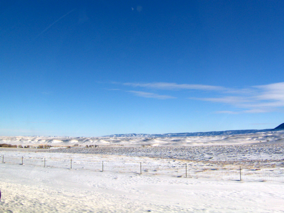
This file photo shows a snowy Casper, Wyoming, field. The state is among those being hit by wintry storms this weekend. (Wyoming_Jackrabbit/Flickr)


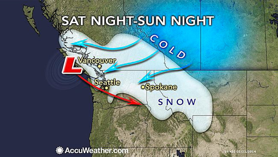
It's shaping up to be a snowy weekend for parts of the Northwest and northern Rockies as waves of snow and cold air move through the region.

Although the highest accumulations will be found in the mountains, snow in the lower elevations can still accumulate enough to cause travel delays in cities such as Spokane, Wash., Billings, Mont., Casper, Wyo. and Vancouver, British Columbia.

The first wave of snow will move in on Saturday, spreading light snow from Washington through Wyoming. A steadier snow looks to move in with the second wave of snow from Sunday afternoon into Sunday night.

Accumulating snowfall will likely stay out of the city of Seattle with much of the precipitation falling as rain. However, some snowflakes may mix in for a time on Saturday night and into early on Sunday morning.

RELATED:
Northwest Interactive Radar
AccuWeather.com Winter Weather Center
Weekend Snow for Southwestern BC

Folks traveling on I-5 north of Seattle should use caution as snow may lead to reduced visibilities and slick spots on roadways.

Those heading into the mountains will encounter the heaviest snow from theses waves of precipitation with nearly a foot of snow accumulating in parts of the Cascades and the Rocky Mountains in Idaho.

Most of the snow looks to end for the start of the new week with only a little snow lingering around in the mountains and across southern Montana and northern Wyoming.

Despite the chance of snow ending west of the Cascades, another batch of rain is set to move in for Monday, bringing more rain to Seattle, Wash.; Portland, Ore.; and Medford, Ore.

RELATED ON SKYE: 15 Photos of Monster Blizzards


Permalink | Email this | Linking Blogs | Comments

Look: Stellar New Shot of the 'Beehive' Star Cluster

$
0
0
On Saturday, Feb. 22, NASA released this new image, shot by Bob Franke, of the M44 star cluster.

Also referred to as the Praesepe, or "Beehive" cluster, the M44 is one of our solar system's closest neighbors, at 600 light-years away.

The Beehive is so-called because of its shape. It is a relatively young group of stars, roughly 600 million years old (our Sun is 4.5 billion years old.) Galileo discovered it using a telescope in 1609.

The brilliant mass of stars definitely makes for a buzz-worthy photo!


Permalink | Email this | Linking Blogs | Comments

Rain Finally Back in the Forecast for California

$
0
0
Saturday, Feb. 22, 2014

As in this file photo, rain is forecast for drought-parched Southern California. (FREDERIC J. BROWN/AFP/Getty Images)


The second half of the upcoming week will feature soaking rain and mountain snow returning to drought-stricken California.

Confidence is growing for California to receive a substantial amount of rain and mountain snow from two storm systems later next week.

The first system is scheduled to move through California Wednesday through Thursday with the second to follow for Friday through the first part of the next weekend.

The second is likely to be the stronger and wetter of the two systems, bringing a much-needed soaking to many communities (with the deserts being the exception).

If the first storm bypasses or only grazes Southern California, the second will not. It is possible that Downtown Los Angeles receives at least half of the rain that fell in all of 2013 (3.60 inches) from this one storm Friday through next weekend.

Several inches of rain could soak the northern California coast, while feet of snow may blanket the Sierra. Snow levels could drop low enough to whiten the mountains of Southern California.

More details and precise rain/mountain snowfall amounts will become clearer in the upcoming days.

RELATED:
Latest Weather-Related Watches, Warnings
Southwest Regional Interactive Radar
Every State May Feel the Effects of Historic California Drought

The upcoming rain and mountain snow will definitely be welcome to a state where the percentage area of places enduring an extreme to exceptional drought was 68 percent on Feb. 18, the U.S. Drought Monitor stated in its latest report.

The number was nearly 61 percent the week prior.

California's Department of Water Resources states that the amount of water stored in the snowpack across the Sierra was only 25 percent of normal on Friday.

As this snow in the Sierra melts during the warmer months, the runoff helps fill reservoirs downstream.

While many residents are likely rejoicing at the news of the returning wet weather, some hazards will also accompany the storms.

Enough rain could fall to trigger flash flooding and mudslides in areas recently burned by wildfires.

At the rain's onset, roads will turn slick as the rain mixes with oil residue left behind by vehicles during the prolonged dry spell.

Motorists could face treacherous travel and chain restrictions in the mountains, including on I-80's Donner Summit. Flight delays may impact airline passengers.

The second storm could also trigger severe thunderstorms.

Before the rainy second half to next week, dry and mild conditions will prevail through Tuesday. Morning low clouds and fog, however, will limit the amount of warming along the coast.

RELATED ON SKYE: Dramatic Photos Reveal California's Epic Drought


Permalink | Email this | Linking Blogs | Comments

Snow to Accompany Return of Cold in East, Midwest

$
0
0
Sunday, February 23, 2014

As in this wintry file photo, snow is once again in the forecast for Philadelphia and other East Coast cities. (AP Photo/Matt Slocum)

Frigid arctic air looks to make a return to the Northeast and Midwest this week following some of the warmest weather the regions have had so far this year, but the colder weather will not return alone.

A series of quick-hitting storms will bring several opportunities for snow across the regions, including the cities of New York, Philadelphia, Pittsburgh, Cleveland and Boston.

Although communities may receive a quick coating to an inch or two from the storms through Tuesday, it does not appear like any of them will bring a substantial amount of snowfall like the nor'easter did nearly two weeks ago.

The first of these fast-tracking storms will pass over the mid-Atlantic and southern New England on Sunday night followed by the first shot of cold air for Monday.

Due to the recent stretch of mild temperatures, precipitation will likely start off as or mix with rain in many locations before changing over to snow.

Even if the snow does not accumulate on roadways, it may still lead to slick travel for motorists where the snow initially melts before temperatures dip below freezing. This could result in areas of black ice for the Monday morning commute.

Another weak system looks to track over the Ohio Valley and mid-Atlantic on Tuesday, bringing the chance for another coating to an inch of snow to Detroit, Cleveland, Columbus and Pittsburgh.

RELATED:
Polar Vortex to Make Encore Performance Midwest, East
AccuWeather.com Winter Weather Center
More Big Snow in the Northeast, Fresh Powder for Colorado and Northwest

Wednesday will bring some big changes to both the Midwest and Northeast as a third storm begins to take shape, possibly bringing the most snow out of all three systems.

It is still unclear the exact path that the storm will take. The closer the storm tracks to the East Coast, the greater the likelihood for disruptive snow along the I-95 corridor.

However, there is still the chance that the storm tracks farther out to sea, bringing very little snow to residents of the Northeast.

While folks along the East Coast will be monitoring the threat of snow for midweek, those in the Midwest will begin to experience the next surge of arctic air due to the polar vortex.

Despite the track of the midweek snowstorm, this blast of polar air is poised to reach the Northeast by Thursday and remaining in place through the rest of the week.

RELATED ON SKYE: 50 Must-See Weather Photos from 2013
Lightning Hits the Grand Canyon


Permalink | Email this | Linking Blogs | Comments


Showers, Storms Could Put the Skids on Today's Daytona 500

$
0
0
Sunday, Feb 23, 2014
during qualifying for the NASCAR Camping World Truck Series NextEra Energy Resources 250 at Daytona International Speedway on February 21, 2014 in Daytona Beach, Florida.
Ryan Ellis, driver of the #28 FDNY Racing Chevrolet, looks on during a rain delay in qualifying for the NASCAR Camping World Truck Series NextEra Energy Resources 250 at Daytona International Speedway on February 21, 2014 in Daytona Beach, Florida. (Photo by Jerry Markland/Getty Images)

There is the risk of showers and thunderstorms affecting this year's Daytona 500 on Sunday, Feb. 23.


While it will not rain the entire weekend, a few downpours should be expected with possible delays during the 56th running of The Great American Race.

A front lingering overhead on Sunday into Monday will bring an ongoing chance of showers and thunderstorms.

People should seek shelter as thunderstorms approach. If you can hear thunder, you are at risk for being struck by lightning.

According to Florida Weather Expert Dan Kottlowski, "While there could be a shower at any time on race day, the chance of more long-lasting drenching rain and a thunderstorm will be later in the day and during the evening at Daytona."

RELATED:
AccuWeather.com Daytona Beach, Fla., Forecast
Daytona Beach Interactive Radar
Severe Weather Watches, Warnings and Advisories

Because of the slick tires, racing cannot occur when the track is wet.

The race has been shortened four times due to rain, during the years 1965, 1966, 2003 and 2009.

However following any early race, rain showers, fans, drivers and crews may not have to wait as long as in the past for a restart.

Equipment introduced to NASCAR during the 2013 season, known as the Air Titan, can be used to accelerate the drying process of the pavement over the older-technology jet dryers.

According to Motor Racing Network, "The machine speeds up the drying time by 80 percent."

Temperatures are forecast to be in the upper 70s for the start of the race, peaking around the 80-degree mark.

"If there are multiple delays due to spotty showers or mishaps early in the event, then the risk of the downpours later on during Sunday could bring an early end to racing for the day, even with improved drying equipment," Kottlowski said.

PHOTOS ON SKYE: 50 Must-See Weather Photos


Permalink | Email this | Linking Blogs | Comments

California Almond Farmers Face Tough Choices

$
0
0
Sunday, Feb. 23, 2014

Alan Thompson of G&F Agri Service LLC looks at a tree as he manages a crew of heavy equipment operators that removed an almond orchard at Baker Farming Company in Firebaugh, Calif., on Monday, Feb. 3, 2014. (AP Photo/Scott Smith)

FIREBAUGH, Calif. (AP) - With California's agricultural heartland entrenched in drought, almond farmers are letting orchards dry up and in some cases making the tough call to have their trees torn out of the ground, leaving behind empty fields.

In California's Central Valley, Barry Baker is one of many who hired a crew that brought in large rumbling equipment to perform the grim task in a cloud of dust.

A tractor operator drove heavy steel shanks into the ground to loosen the roots and knock the trees over. Another operator, driving a brush loader equipped with a fork-like implement on the front, scooped up the trees and root balls and pushed them into a pile, where an excavator driver grabbed them up in clusters with a clawing grapple. The trees were fed into a grinder that spit wood chips into piles to be hauled away by the truckload and burned as fuel in a power plant.

Baker, 54, of Baker Farming Company, has decided to remove 20 percent of his trees before they have passed their prime. There's simply not enough water to satisfy all 5,000 acres of almonds, he said. "Hopefully, I don't have to pull out another 20 percent," Baker said, adding that sooner or later neighboring farmers will come to the same conclusion. "They're hoping for the best. I don't think it's going to come."

There are no figures yet available to show an exact number of orchards being removed, but the economic stakes and risks facing growers are clear. Almonds and other nuts are among the most high-value crops in the Central Valley - the biggest producer of such crops in the country. In 2012, California's almond crop had an annual value of $5 billion. This year farmers say the dry conditions are forcing them to make difficult decisions.

Gov. Jerry Brown last month declared a drought emergency after the state's driest year in recorded history.

The thirst for water has sparked political battles in Washington, D.C., over use of the state's rivers and reservoirs. This month President Barack Obama visited the Central Valley, announcing millions of dollars in relief aid that in part will help the state's ranchers and farmers better conserve and manage water.

Baker, who favors farming over politics, explained the math leading to his decision. Between now and the summer almond harvest, he would need to irrigate his orchards with scarce, expensive water and pay to have the trees pruned and sprayed. Bringing in bee hives to pollinate the blossoms costs nearly $500 an acre.

That all would amount to a $2.5 million gamble, without knowing if the next couple of months will bring significant rain to the valley floor and snow to the mountains. "You'd have wrapped a lot of money up in those trees to see what happens," he said.

Removing old trees is common practice. Almond trees remain productive for about 25 years, growers said. The state's almond farmers removed over 10,000 acres of trees in 2012, according to a report by the California Department of Food and Agriculture. Most were past their prime. No figures are available on how many orchards farmers are removing today, said department spokesman Steve Lyle.

But Alan Thompson of G&F Agri Service LLC, who leads the crew ripping out Baker's orchards, said the drought spiked his business by 75 percent. This time of year is typically slow, but Thompson, 31, said his heavy equipment operators start at dawn each day and works until sundown, removing orchards in short order.

"We don't even mess around with cutting them up with chain saws," he said. "That grinder is the way to do it right there."

Ryan Jacobsen, executive director of the Fresno County Farm Bureau, said he expects that almond growers will be removing trees through the spring and summer because of the drought. "I have no doubt permanent crops will be taken out because of this," he added.

Tim Lynch of Agra Marketing Group said power plants in the state nearly have more wood chips from almond trees than they can handle. Lynch's firm acts as the middle man between growers getting rid of their trees and the power plants that need bio fuel to burn. The dry weather this winter has allowed growers to work in their orchards that are typically soggy, and the drought pushed them to take out trees earlier than normal, he said.

The high value of almonds has caught the eye of investors in recent years, who paid top-dollar for land to plant almond orchards and cash in on the bonanza. Their value remains strong, making the decision for farmers to remove orchards difficult.

William Bourdeau, executive vice president of Harris Farms in Coalinga, said he and his colleagues within the next 30 days will have to confront the hard decision about scaling back their almond orchards. They've already decided not to plant 9,000 acres of vegetables - including 3,000 acres of lettuce that would have produced 72 million heads and generated 700,000 hours of work.

Next, they may rip out 1,000 acres of almonds, a permanent crop, Bourdeau said.

"I hesitate to use a number that big. Unfortunately, it's going to that big or bigger," he said, still holding out hope the season will turn wet. "We're trying to limp along as long as we can."

Leaving the orchards un-watered and expecting they'll somehow survive the drought is no option, Bourdeau said, because insects infest the dying trees and multiply, spreading to other orchards.

Drawing well water is a bad option, he said. Their wells sink 2,400 feet below ground in his region of the Central Valley, providing water that's unhealthy and compromises the crops for years, if the trees survive at all, he said.

They have considered blending well and surface water to minimize the harm. Or they can remove some almonds to direct their limited water to fewer orchards.

"There's a lot of what-ifs," Bourdeau said. "There's no good decision. It's what's the least worse option."

RELATED ON SKYE: Dramatic Photos Reveal California's Epic Drought


Permalink | Email this | Linking Blogs | Comments

Japanese Astronaut Creates Amazing Light Spirals in Space

$
0
0
Sunday, Feb. 23, 2013

Astronaut Koichi Wakata tweeted this photo of the "Spiral Top" from aboard the International Space Station on Jan. 6, 2014. The toy uses LED lights to make art in zero-g conditions. (​Koichi Wakata)

A Japanese astronaut created a microgravity, multicolored light show on the International Space Station in the name of art.

Japan Aerospace Exploration Agency (JAXA) astronaut Kiochi Wakata has been using a specialized device that can to create swirly light art in weightlessness on the orbiting outpost. Known as a "spiral top," the instrument is outfitted with LED lights so that when spun, the top will create light trails that can be captured in photos.

"In microgravity, the center of gravity of the spinning top continuously and randomly moves while it is spinning," JAXA officials said in an experiment description. "Using the characteristics of the top in microgravity, the project tries to produce various light arts using its unexpected movements/spins, by changing attaching locations of its arms and weights." [See more amazing photos from astronaut Kiochi Wakata]

The end result of those spins in microgravity is an amazing light portrait that looks otherworldly. Wakata posted a few photos on Twitter earlier in January 2014 that show blue, green, yellow and red spirals shooting through a module on the space station. "Potential of what zero-gravity can create is unlimited!" Wakata (@Astro_Wakata) wrote on Twitter in a post from Jan. 6.

"When we ask astronauts to carry out an art experiment, they work on it with great excitement and enthusiasm," Keiji Tachikawa, president of JAXA, said in a 2011 Q&A. "I believe that experiments for the humanities and social sciences have a great deal of meaning. How we can culturally reflect the wonderful results that have been achieved thus far -- this will be a moment of truth."

This isn't the first time JAXA has worked with a spiral top, originally created by Takuro Osaka. Astronauts used an earlier version of the experiment to create light art in 2009 on the space station as well.

Wakata is currently one of six international crewmembers living and working on the International Space Station. NASA astronauts Mike Hopkins and Rick Mastracchio, cosmonauts Mikhail Tyurin, Sergey Ryazanskiy and Oleg Kotov join him to round out the space laboratory's Expedition 38 crew. Mastracchio, Tyurin and Wakata are scheduled to fly back to Earth aboard their Russian Soyuz spacecraft in May.

The $100 billion space station is the largest structure ever built in space. It has the wingspan of a football field and the living space of a five-bedroom house. Crews of astronauts and cosmonauts have continuously staffed the orbiting outpost since 2000.

Follow Miriam Kramer @mirikramer and Google+. Follow us @Spacedotcom, Facebook and Google+. Original article on Space.com.

Copyright 2014 SPACE.com, a TechMediaNetwork company. All rights reserved. This material may not be published, broadcast, rewritten or redistributed.
RELATED ON SKYE: 25 Amazing Photos of the International Space Station
International Space Station, Shuttle


Permalink | Email this | Linking Blogs | Comments

Volcanoes Believed to Cause Global Warming 'Pause'

$
0
0
Sunday, Feb. 23, 2014

From the initial eruptive activity at Eyjafjallajokull volcano in 2010, that was a lava producing eruption that lasted from March 20 through April 12, preceding the explosive eruption. View of the eruptive fissure on March 25, 2010. (Thorsteinn Jonsson, University of Iceland)

Cooling caused by volcanic eruptions accounts for 15 percent of the recent global warming "pause," the mismatch between actual warming and climate-model predictions, according to a new study.

The slowdown in global warming, sometimes called a pause or hiatus, started in 1998, when Earth's average surface temperatures halted their feverish rise. The average rate of warming was 0.31 degrees Fahrenheit per decade between 1970 and 1998, but dropped to 0.072 F per decade between 1998 and 2012. The Intergovernmental Panel on Climate Change (IPCC) had predicted the temperature trends seen in the 20th century to continue at their disco-era pace.

It turns out that a series of 17 small volcanic eruptions since 2000 pumped enough aerosols into the atmosphere to explain a significant portion of the slowdown, researchers report today (Feb. 23) in the journal Nature Geoscience. Aerosols are fine, airborne particles -- such as sulfate -- that scatter the sun's energy, cooling the Earth. This cooling has offset the ongoing warming caused by greenhouse gases such as carbon dioxide, the researchers said. (All told, humans have released about 100 times more carbon dioxide than the amount of CO2 belched by volcanoes since 1750, according to the IPCC.)

"Part of the lack of the increase in warming for the last 15 years may be due to the cooling effect of volcanoes," said Coline Bonfils, a study co-author and climate scientist at Lawrence Livermore National Laboratory (LNNL) in Livermore, Calif.

Small but mighty

In 2011, scientists discovered that small volcanoes can significantly change the planet's climate. Before then, researchers thought that only big eruptions the size of 1991's Mount Pinatubo blast could effectively cool the Earth. Most climate models reflected this bias toward big eruptions, ignoring climate shifts from smaller blasts. [Video: The Painterly Mixing Of Aerosols In Our Atmosphere]

"The most recent [climate] simulations include all the major volcanoes up until Pinatubo in 1991; then the aerosols decay back to zero," said Mark Zelinka, a study co-author and LLNL climate scientist. "It was only recently that it was known that these medium-sized volcanoes were putting a lot of highly reflective particles into the stratosphere." The stratosphere is the layer of the atmosphere above the one in which people live (the troposphere), and extends about 6 to 31 miles above Earth's surface.

In the new study, the researchers correlated 17 volcanic eruptions since 2000 with shifts in troposphere temperatures, for which there is a global satellite record of temperature trends. The same stumble in warming trends since 1998 also hit the troposphere.

The 17 volcanoes include some that made worldwide headlines, such as Iceland's troublesome Eyjafjallaj ∂kull, and less-disruptive eruptions, such as 2011's lava flows at Nabro, in Eritrea.

Using computer models and statistical tests, the researchers calculated that aerosols from the volcanoes reduced global troposphere temperatures. The aerosols also cooled the troposphere by reflecting sunlight.

"We see a statistically significant correlation with not only temperature, but reflected sunlight -- which are both independent measures," Zelinka said. "That is a pretty key advance."

The results show that the slowdown in global warming can't be pinned on a single culprit, the researchers said. Other factors blamed for the global-warming slowdown include an uptick in sulfur-dioxide pollution from China and an unusually long minimum in solar activity. Recent measurements of deep ocean temperatures also indicate some of the missing heat is being absorbed at deeper levels in the ocean -- a result supported by continued sea level rise. (Water expands as it warms.)

"The devil is really in the details," said Ryan Neely, an atmospheric scientist at the National Center for Atmospheric Research in Boulder, Colo., who was not involved in the study. "What's important these days is how do you get down to decadal-scale predictability in climate change and global warming, and you have to pay attention to every detail, every eruption.

"This is the first really rigorous test of whether changes in volcanic activity relate to tropospheric temperatures, and they've done a really excellent job," Neely said.

Email Becky Oskin or follow her @beckyoskin. Follow us @livescience, Facebook & Google+. Original article on Live Science.

Copyright 2014 LiveScience, a TechMediaNetwork company. All rights reserved. This material may not be published, broadcast, rewritten or redistributed.

RELATED ON SKYE: 25 Incredible Photos of Volcanic Eruptions
Lightning, Volcano


Permalink | Email this | Linking Blogs | Comments

Costly, Political, Successful: Sochi Olympics End

$
0
0
Sunday, Feb. 23, 2014

Fireworks explode over Olympic Park during the closing ceremony for the 2014 Winter Olympics, Sunday, Feb. 23, 2014, in Sochi, Russia. (AP Photo/Matt Slocum)

SOCHI, Russia (AP) - Flushed with pride after its athletes' spectacular showing at the costliest Olympics ever, Russia celebrated Sunday night with a visually stunning finale that handed off a smooth but politically charged Winter Games to their next host, Pyeongchang in South Korea.

Russian President Vladimir Putin, these Olympics' political architect and booster-in-chief, watched and smiled as Sochi gave itself a giant pat on the back for a Winter Games that IOC President Thomas Bach declared an "extraordinary success."

The crowd that partied in Fisht Olympic Stadium, in high spirits after the high-security games passed safely without feared terror attacks, hooted with delight when Bach said Russia delivered on promises of "excellent" venues, "outstanding" accommodation for the 2,856 athletes and "impeccable organization." The spectators let out an audibly sad moan when Bach declared the 17-day Winter Games closed.

"We leave as friends of the Russian people," Bach said.

The nation's $51 billion investment - topping even Beijing's estimated $40 billion layout for the 2008 Summer Games - transformed a decaying resort town on the Black Sea into a household name. All-new facilities, unthinkable in the Soviet era of drab shoddiness, showcased how far Russia has come in the two decades since it turned its back on communism. But the Olympic show didn't win over critics of Russia's backsliding on democracy and human rights under Putin and its institutionalized intolerance of gays.

Despite the bumps along the way, Bach was unrelentingly upbeat about his first games as IOC president and the nation that hosted it. One of Sochi's big successes was security. Feared attacks by Islamic militants who threatened to target the games didn't materialize.

"It's amazing what has happened here," Bach said a few hours before the ceremony. He recalled that Sochi was an "old, Stalinist-style sanatorium city" when he visited for the IOC in the 1990s.

Dmitry Chernyshenko, head of the Sochi organizing committee, called the games "a moment to cherish and pass on to the next generations."

"This," he said, "is the new face of Russia - our Russia."

His nation celebrated its rich gifts to the worlds of music and literature in the ceremony, which started at 20:14 local time - a nod to the year that Putin seized upon to remake Russia's image with the Olympics' power to wow and concentrate global attention and massive resources.

Performers in smart tails and puffy white wigs performed a ballet of grand pianos, pushing 62 of them around the stadium floor while soloist Denis Matsuev played thunderous bars from Sergei Rachmaninoff's Concerto No.2.

There was, of course, also ballet, with dancers from the Bolshoi and the Mariinsky, among the world's oldest ballet companies. The faces of Russian authors through the ages were projected onto enormous screens, and a pile of books transformed into a swirling tornado of loose pages.

There was pomp and there was kitsch. The games' polar bear mascot - standing tall as a tree - shed a fake tear as he blew out a cauldron of flames, extinguishing the Olympic torch that burned outside the stadium. Day and night, the flame had become a favorite backdrop for "Sochi selfies," a buzzword born at these games for the fad of athletes and spectators taking DIY souvenir photos of themselves.

"Now we can see our country is very friendly," said Boris Kozikov of St. Petersburg, Russia. "This is very important for other countries around the world to see."

And in a charming touch, Sochi organizers poked fun at themselves. In the center of the stadium, dancers in shimmering silver costumes formed themselves into four rings and a clump. That was a wink to a globally noticed technical glitch in the Feb. 7 opening ceremony, when one of the five Olympic rings in a wintry opening scene failed to open. The rings were supposed to join together and erupt in fireworks.

This time, it worked: As Putin watched from the stands, the dancers in the clump waited a few seconds and then formed a ring of their own, making five, drawing laughs from the crowd.

Raucous spectators chanted "Ro-ssi-ya! Ro-ssi-ya!" - "Russia! Russia!" They got their own Olympic keepsakes - medals of plastic with embedded lights that flashed in unison, creating pulsating waves of color across the stadium.

Athletes said goodbye to rivals-turned-friends from far off places, savoring their achievements or lamenting what might have been - and, for some, looking ahead to 2018. The city where they will compete, Pyeongchang, offered in its segment of the show a teaser of what to expect in four years with video of venues, Korean music and delightful dancers in glowing bird suits.

Winners of Russia's record 13 gold medals marched into the stadium carrying the country's white, blue and red flag. With a 3-0 victory over Sweden in the men's hockey final Sunday, Canada claimed the last gold from the 98 medal events.

Absent were six competitors caught by what was the most extensive anti-doping program in Winter Olympic history, with the IOC conducting a record 2,631 tests - nearly 200 more than originally planned.

Russia's leader had reason to be pleased as the Olympics dubbed the "Putin Games" ended. His nation's athletes topped the Sochi medals table, both in golds and total - 33. That represented a stunning turnaround from the 2010 Vancouver Games. There, a meager three golds and 15 total for Russia seemed proof of its gradual decline as a winter sports power since Soviet Union collapsed in 1991. Russia's bag of Sochi gold was the biggest-ever haul by a non-Soviet team.

Russia's last gold came Sunday in four-man bobsled. The games' signature moment for home fans was Adelina Sotnikova, cool as ice at 17, becoming Russia's first gold medalist in women's Olympic figure skating.

Not every headline out of Sochi was about sport. Going in, organizers faced criticism about Russia's strict policies toward gays, though once they started sliding and skiing and skating, most every athlete chose not to use the Olympic spotlight to campaign for the cause. An activist musical group and movement, Pussy Riot, appeared in public and was horsewhipped by Cossack militiamen, drawing international scrutiny.

And during the last days of competition, Sochi competed for attention with violence in Ukraine, Russia's neighbor and considered a vital sphere of influence by the Kremlin.

In an Associated Press interview on Saturday, Bach singled out Ukraine's victory in women's biathlon relay as "really an emotional moment" of the games, praising Ukrainian athletes for staying to compete despite the scores dead in protests back home.

"Mourning on the one hand, but knowing what really is going on in your country, seeing your capital burning, and feeling this responsibility, and then winning the gold medal," he said, "this really stands out for me."

PHOTOS ON SKYE: Olympic Athletes Defy Russian Airspace


Permalink | Email this | Linking Blogs | Comments
Polar Vortex to Once Again Grip Midwest, Northeast

$
0
0

Updated Monday, Feb. 24, 2014, 5:36 p.m. ET
Deep Freeze
Morning commuters are seen bundled up Tuesday, Jan. 28, 2014, in Chicago. (AP Photo/Kiichiro Sato)

Last week's thaw was a mere tease for the Midwest and Northeast with the polar vortex set to make an encore performance this week.

The stretch of mild weather across the Northeast came to an end with the weekend after temperatures rose into the 60s in Washington, D.C., and into the 50s in Philadelphia, New York City and Boston.

Waves of colder air will pour down from the depths of the Arctic to the northern Rockies, Midwest and Northeast as this week progresses and the polar vortex plunges southward.

Polar Vortex Returns

Each cold blast will dip into the southern Plains and South, leading to some cooling. However, the core of the polar vortex will have a firm grip on the northern tier of the U.S.

RELATED:
Snow to Return With Cold Air This Week in Midwest, East
AccuWeather Winter Weather Center
Four Foods That Help Prevent Slippery Roads

"The polar vortex is essentially a mass of very cold air that usually hangs out above the Arctic Circle and is contained by strong winds," stated AccuWeather.com Senior Meteorologist Alex Sosnowski.

Under the grip of the polar vortex, the Upper Midwest, Great Lakes and St. Lawrence Valley will endure several days in the teens and single digits. This includes Minneapolis, Chicago, Detroit, Montreal and Buffalo, N.Y.

Polar Vortex Returns

Overnight lows well below zero, even approaching 30 below zero near the Canadian border, will dominate the Upper Midwest.

Temperatures will even be held below zero during the daylight hours on one or more days in Winnipeg, Canada, Fargo, N.D., and St. Cloud, Minn.

Polar Vortex Returns

Subfreezing highs in the 20s and lower 30s will be common throughout the Northeast. In late February, such highs are 10 to 20 degrees below normal.

Bouts of gusty winds ushering in the frigid air will create even lower AccuWeather.com RealFeel(R) temperatures.

"One reason for the cold blast carrying more weight than you might expect is the fact that the Great Lakes are largely frozen over," Sosnowski continued.

"The air will not moderate to the extent as if most of the lakes were not frozen. In addition, while the amount and extent of the snow on the ground has diminished, many areas north of I-70 have retained some sort of snow cover."

With fresh snow also re-entering the picture, some communities will have snow cover once again increase.

Initially, nuisance snow events with amounts generally on the order of a coating to an inch or two will streak across the Midwest and Northeast through Tuesday.

The greatest chance of snow in the Northeast--including the I-95 corridor from Washington, D.C. to Boston--will come on Wednesday as a low tracks off the East Coast.

Although accumulations are expected to be on the lighter side, they may still lead to some minor travel delays including flight delays and cancelations.

Polar Vortex Returns

Later in the week and through the start of March, with the cold air still in place and storms finallyreturning rain and mountain snow to California, the path could be laid for one or more disruptive snowstorms to travel from the Rockies to the Plains to the East Coast.

AccuWeather.com meteorologists will continue to monitor the potential for such snowstorms and will give more information as it becomes available.

RELATED ON SKYE: 22 People More Sick of Winter Than You Are


Read | Permalink | Email this | Linking Blogs | Comments
Concerns Mount at Vineyards as Historic California Drought Persists

$
0
0
Monday, Feb. 24, 2014

This Oct. 27, 2011, file photo shows a sign along Highway 29 welcoming visitors to the Napa Valley in Oakville, Calif. (AP Photo/Eric Risberg, File)

Following a drought State of Emergency issued for California in December, worries continue to mount over the economic implications of the region's long-lasting dry weather, especially for the wine industry.

"It's giving us ulcers," Family Owner of Husch Vinyards, located in California's Anderson Valley, Zac Robinson said.

While grape vines are currently in their dormant stage and do not have any specific water needs, a drought in combination with warmer-than-normal temperatures can tease the into waking up earlier. After waking up, the vines will bud, creating an even bigger challenge for growers as the potential for frost still looms.

"One of the ways that grape growers mitigate against frost is doing overhead watering," Executive Director of Santa Barbara Vineyards Morgan McLaughlin said. "If there is no water or there is restricted use on water then there is less potential frost protection."

During this time of year, growers have their most intense water need and can use more water overnight in April then they would use for an entire summer's worth of irrigation, according to Robinson.

Due to the lack of water resources throughout the state, growers are faced with difficult questions about what to do if they will have only enough water to frost protect or irrigate but not both.

"It's one of those catch-22s," Robinson said. "If you get the vines through the frost without any serious damage but have no water to irrigate then what was the point? If you save water to irrigate and they take frost damage then what was the point in that? There is no good answer to that question."

In addition, the lack of rain will increase the salt content in the soil, as fall rains usually wash away some salt concentration. A high salt concentration creates a toxic environment for grape vine roots, making it hard for them to absorb nutrients and thus produce a good crop, according to Owner and Consultant of Foxx Viticulture Prudy Foxx.

"Many people will probably experience some type of reduced crop just because their grape vines weren't able to eat last fall and the spring rains we are getting now are not making up for that," Foxx said.

RELATED:
Rain Finally Back in the Forecast for California
Southwest Regional Weather Radar
Every State May Feel the Effects of Historic California Drought

Luckily for growers, even a reduced crop this year may not have an enormous economic impact right away because the 2012 and 2013 growing seasons were phenomenal years for the California wine industry.

Due to the nature of wine, the grapes harvested in 2014 will not go on the market until at least 2016, creating a time lapse that may enable growers to make up for this year's reduced crop.

"It's always two or three years down the road before you are dealing with that year's harvest so even though the impact of the weather is so significant it doesn't really translate for several years," Foxx said. "Essentially consumers are drinking the weather of three years ago."


The cracked-dry bed of the Almaden Reservoir is seen on Friday, Feb. 7, 2014, in San Jose, Calif. (AP Photo/Marcio Jose Sanchez)

Since the 2012 and 2013 harvests were almost picture perfect, according to Foxx, this year may in fact be a buyer's market, as wineries will likely bring out wines that haven't been seen in a while and wines from those two seasons to stock the shelves.

"There will be some really great wines out in the next few years because of the 2012 and 2013 seasons and that's something everyone can look forward to," Foxx said.

While this may aid in glossing over what is likely to be a poor crop this season, the real threat from this year's drought will occur next year if conditions do not improve.

"It will really be a crisis for us next year," Monterey Pacific President and Founder Steve McIntyre said. "What we will ultimately do is farm the varieties of the most value, not farm the rest and just try to keep the vines alive and conserve water."

Even though some rain may fall over portions of California in the coming days, a change large enough to reverse the drought won't be coming anytime soon due to the drought's longevity and this only fuel's growers concerns.

"Unlike Coca-Cola, we can only make our product once a year and we are dependent on an agricultural product, our grapes, so if any part of the system breaks such as water, bad weather, insect problems, etc., that immediately impacts a year's worth of production," Robinson said.


RELATED ON SKYE: 7 Surprising Health Effects of Drought


Read | Permalink | Email this | Linking Blogs | Comments


Rain Finally Back in the Forecast for California

$
0
0

Updated Monday, Feb. 24, 2014, 4:42 p.m. ET
Drought Damages Vines As California Wine Growers Sink New Wells
Workers prune vines at the Russell Family Vineyard near Paso Robles, Calif., U.S., on Tuesday, Feb. 18, 2014. (David Paul Morris/Bloomberg via Getty Images)

The second half of this week will feature soaking rain and mountain snow returning to drought-stricken California.

Confidence is growing for California to soon receive a substantial amount of rain and mountain snow from two storm systems.

The first system is scheduled to move through California Wednesday through Thursday with the second to follow for Friday through the first part of the next weekend.


The second is likely to be the stronger and wetter of the two systems, bringing a much-needed soaking to many communities (with the deserts being the exception).

If the first storm bypasses or only grazes Southern California, the second will not. It is possible thatDowntown Los Angeles receives at least half of the rain that fell in all of 2013 (3.60 inches) from this one storm Friday through next weekend.

Several inches of rain could soak the northern California coast, while feet of snow may blanket the Sierra. Snow levels could drop low enough to whiten the mountains of Southern California.

More details and precise rain/mountain snowfall amounts will become clearer in the upcoming days.

The upcoming rain and mountain snow will definitely be welcome to a state where the percentage area of places enduring an extreme to exceptional drought was 68 percent on Feb. 18, the U.S. Drought Monitor stated in its latest report.

The number was nearly 61 percent the week prior.

California's Department of Water Resources states that the amount of water stored in the snowpack across the Sierra was only 25 percent of normal on Friday.

RELATED:
Latest Weather-Related Watches, Warnings
Southwest Regional Interactive Radar
Every State May Feel the Effects of Historic California Drought

As this snow in the Sierra melts during the warmer months, the runoff helps fill reservoirs downstream.

While many residents are likely rejoicing at the news of the returning wet weather, some hazards will also accompany the storms.

Enough rain could fall to trigger flash flooding and mudslides in areas recently burned by wildfires.

At the rain's onset, roads will turn slick as the rain mixes with oil residue left behind by vehicles during the prolonged dry spell.

Motorists could face treacherous travel and chain restrictions in the mountains, including on I-80's Donner Summit. Flight delays may impact airline passengers.

The second storm could also trigger severe thunderstorms.

Before the rainy second half to next week, dry and mild conditions will prevail through Tuesday. Morning low clouds and fog, however, will limit the amount of warming along the coast.

RELATED ON SKYE: 7 Surprising Health Effects of Drought


Permalink | Email this | Linking Blogs | Comments

Rain May Dampen Start of Baseball Spring Training in Florida

$
0
0

Monday, Feb. 24, 2014
Phillies Spring Baseball

It's the annual rite of going from winter to spring: Major League Baseball's Spring Training.

The Cactus and Grapefruit leagues begin play on Wednesday in Arizona and Florida, respectively.

It could be a wet start to Spring Training 2014 as a front stalls across south-central Florida, AccuWeather.com meteorologist Brian Edwards said.

"There may be multiple opportunities for showers and thunderstorms," Edwards said.

The first official Grapefruit League game will be Wednesday between the Toronto Blue Jays and Philadelphia Phillies at Bright House Field, Clearwater, Fla. First pitch is slated for 1:05 p.m. EST.

The Oakland Athletics and the San Francisco Giants open Cactus League play with a 3:05 p.m. EST start at Scottsdale Stadium, Scottsdale, Ariz. At the same time, the Cincinnati Reds and Cleveland Indians take the field at Goodyear Ballpark, Goodyear, Ariz.

"There will be comfortable temperatures in the mid- to upper 70s with partly sunny skies Wednesday through Friday," Edwards said.

RELATED:
Arizona Interactive Radar
AccuWeather.com Flight Tracker
Florida Interactive Radar

There may be a chance of rain for the weekend in Arizona but it depends on how much precipitation may move through as a result of a storm system expected to bring beneficial rains to California.

MLB's opening series will be held March 22 and 23 in Sydney, Australia, between the Los Angeles Dodgers and the Arizona Diamondbacks.

March 30 is Opening Night with March 31 as Opening Day.

RELATED ON SKYE: 50 Must-See Weather Photos
Lightning Hits the Grand Canyon


Permalink | Email this | Linking Blogs | Comments

Al Roker, NYC Mayor Smooth Over Their Snow Spat

$
0
0

NEW YORK (AP) - TV weatherman Al Roker and New York City's mayor have made up after a spat over snow and school closings.

Mayor Bill de Blasio the meteorologist met cordially on camera on NBC'S "Today" show Monday. Earlier this month, Roker chastised de Blasio on Twitter for keeping schools open during a storm that left nearly 10 inches of snow.

Roker said Monday the two chatted about the issue and both "want the best for the school kids and our city." De Blasio agreed and says letting people know about weatherhazards is "something we do together."

He gave Roker a city Sanitation Department ball cap and invited him to join in next time the city needs plowing.

The National Weather Service is forecasting snow in the city Wednesday and Saturday.


RELATED ON SKYE: 20 Photos of Monster Blizzards


Permalink | Email this | Linking Blogs | Comments

Photos: The World's Weirdest Plants

Watch: Beautiful Time-Lapse Video Shows Snowflakes Form

Viewing all 4069 articles
Browse latest View live


Latest Images