Quantcast
Channel: SKYE on AOL
Viewing all 4069 articles
Browse latest View live

Dangerous Winter Storm Targets Northwest, West

$
0
0
Thursday, Feb. 6, 2014
Oregon Winter Weather
(AP Photo/Rick Bowmer)

While winter has been in full swing across the eastern two-thirds of the nation since seemingly late November, the West has had a hard time finding much in the way of extreme cold or snow.

That will all change on Thursday and persist right through the weekend as a series of storm systems aimed at the West Coast crashes into an arctic high pressure sitting overhead. Snow will start falling across Portland in the afternoon on Thursday and continue, in waves, throughout the day on Saturday.

Accompanying the snow will be strong winds from the east blowing out of the Columbia River Gorge. Areas such as Troutdale, Multnomah Falls, Cascade Locks and Corbett, all in Oregon, will likely see blizzard conditions and nearly impossible travel beginning in the afternoon Thursday and lasting into Saturday.

Those expecting to travel on I-84 through the Gorge should be prepared for very hazardous conditions, such as blinding snow, whiteouts, extreme cold, road closures and the possibility of becoming stranded.

Similarly, those who will head south on I-5 will need to be ready for potentially life-threatening weather, especially when traveling through higher elevations south of Eugene.

RELATED:
AccuWeather.com Winter Weather Center
MAP: Current Weather Watches, Warnings and Advisories
East Coast Weekend Storm May Come in Two Waves

Snowfall in Portland will likely range from as little as 1 inch to as much as 6 inches in eastern parts of the city. In the Cascades, snowfall of at least 6 inches is likely, with amounts exceeding 1 foot in the highest elevations.

Farther south into northern California and the Sierra, heavy snow will also fall. Accumulations will generally ranger from a few inches in the elevations above 2,500 feet to over 6 inches in the highest elevations.

In terms of the ongoing drought that has gripped parts of the West for years, the moisture with this system will only make a small dent in the huge precipitation deficits that have been racking up.

In many areas along the West Coast, anywhere from 18 to as much as 36 inches of rainfall is needed to bring an end to the drought, and that does not appear likely any time soon.

Here is a detailed look at the Northwest forecast.

RELATED ON SKYE: The 10 Snowiest Places on Earth


Read | Permalink | Email this | Linking Blogs | Comments


Storm Leaves Hundreds of Thousands in the Dark

$
0
0
Updated Thursday, Feb. 6, 2014, 10:45 a.m. ET
APTOPIX Winter Weather
A man inspects an ice covered downed tree that took out an utility line and landed atop a minivan, after a winter storm Wednesday, Feb. 5, 2014, in Philadelphia. (AP Photo/Matt Rourke)

PHILADELPHIA (AP) - Utility crews worked to restore power to hundreds of thousands of homes and businesses that were still in the dark and cold Thursday after an ice storm knocked out electricity to more than a million customers, damage one official likened to that of a hurricane.

The Northeast's second winter storm of the week dumped more than a foot of snow Wednesday, forcing schools, businesses and government offices to close, snarling air travel and sending cars and trucks sliding on slippery roads and highways - an all-too-familiar litany of misery in a winter where the storms seem to be tripping over each other.

What made this one stand out was the thick coating of ice it left on trees and power lines, causing outages that are expected to linger for days.

PHOTOS: Winter Storm Slams Midwest to Northeast
Pennsylvania was particularly hard hit, with more than a quarter inch of ice over a large section of the state. At its height, the storm knocked out power to nearly 849,000 customers in Pennsylvania, most of them in the counties surrounding Philadelphia.

"People are going to have to have some patience at this point," Pennsylvania Gov. Tom Corbett said. The governor issued a disaster emergency proclamation, freeing up state agencies to use all available resources and personnel.

About 3,500 workers from as far away as Canada and Arkansas were working with PECO, southeastern Pennsylvania's dominant utility, to restore power, company spokesman Ben Armstrong said. The repair efforts would extend into - and possibly through - the weekend, he said.

While the utility had made headway in restoring power, "some tree limbs and some trees are still coming down on our lines and causing outages for customers," he said Thursday.

"The damage that we are seeing in the field with the number of trees down, not only on lines but blocking roads and more, presents a number of logistical issues," Pennsylvania Public Utility Commission spokeswoman Jennifer Kocher said. "This damage is very similar to what we see during hurricanes."

Officials pleaded with people not to use generators or gas grills indoors after 20 to 25 people in the Philadelphia area were taken to hospitals with carbon monoxide poisoning.

While some homeowners fired up generators, others, like Dave Dixon and his wife, relied on the generosity of others to power them through. They planned to stay with friends overnight Thursday - and possibly longer.

"If we wear out our welcome, we'll get a hotel," said Dixon, whose home in the Philadelphia suburbs went dark at 6 a.m. Wednesday.

In Wyncote, just north of Philadelphia, Hannah Reimer took to Facebook to ask for a kerosene heater and recommendations on where to buy the fuel.

"It worked! Someone from my church, who has power, has a kerosene heater and my husband is picking it up now," she said Wednesday night.

Reimer and her husband then planned to pay it forward, inviting their neighbors to spend the night.

"Our neighbors don't have heat, either," she said. "Or a kerosene heater."

As of Thursday morning, PECO reported more than 429,000 customers without power. FirstEnergy was reporting more than 50,000 customers without power, mostly in central Pennsylvania, while PPL was reporting almost 20,000 in its northeastern Pennsylvania service area.

In neighboring Maryland, where 76,000 customers were in the dark, power companies gave a restoration estimate of Friday. More than 5,000 New Jersey customers also lacked electricity.

The storm was the second-worst in PECO's history - eclipsed only by the nearly 1.8 million that were left without power after Superstorm Sandy in 2012 - with the utility reporting 623,000 outages at one point Wednesday.

Several hospitals were running on backup generators. Most decided to cancel elective surgeries and out-patient testing.

Dr. John Kelly, chief of staff at Abington Memorial Hospital outside Philadelphia, one of the affected facilities, said critical staff needed for any emergencies would be staying overnight. He said the hospital had plenty of fuel and food.

The American Red Cross opened three shelters in southeastern Pennsylvania and stood ready to open more.

"We've been told to be prepared for four to six days. We are gathering staff and volunteers for up to a week," spokesman Dave Schrader said.

PHOTOS ON SKYE: Winter Storm Hits from Midwest to Northeast
Kansas Winter Storm Photos


Permalink | Email this | Linking Blogs | Comments

Weeks After Avalanches, Lone Road to Valdez Opens

$
0
0
Thursday, Feb. 6, 2014
Avalanches Cut Off City
A photo released Wednesday Jan. 29, 2014, by the Alaska Department of Transportation & Public Facilities and made on Jan. 25, 2014, shows road crews beginning the job of clearing the closed Richardson Highway, near Valdez, Alaska. (AP Photo/Alaska DOT&PF)

VALDEZ, Alaska (AP) - Two weeks after cascades of snow prevented vehicles from getting into this city at the end of the trans-Alaska pipeline, the only road to Valdez has reopened.

Crews finished clearing away the remaining avalanche debris, and there was no damage to Richardson Highway, the Anchorage Daily News reported (http://is.gd/nvV4Mr ).

A dozen or so avalanches combined to close the road on Jan. 24, including two that completely covered the highway and about 10 that partially covered it.

One major avalanche was in Thompson Pass at Mile 39. That avalanche and the smaller ones were cleared last week.

Another big avalanche filled Keystone Canyon, which begins at Mile 12 and is roughly 300 feet wide. Snow piled up on the road 40 to 50 feet high from canyon wall to canyon wall for 1,000 to 1,500 feet.

It also dammed the Lowe River, creating a lake that covered 2,500 feet of highway. Excavation crews could not reach the upstream side of the avalanche until last Friday after water drained or returned to the river channel.

"We live in a really cool place where these events just make it really interesting," Josh Miller, a teacher at Valdez High School, told the newspaper. He's been taking his classes outside to examine avalanche debris over the past two weeks.

Kate Dugan couldn't leave her subdivision just outside of Valdez for almost a week.

"I had a very understanding boss who let me work from home," said Dugan, who works in communications for the Alyeska Pipeline Services Co. "But life kind of continued on, maybe quieter or mellower. I was able to bake a little more bread."

Valdez City Manager John Hozey called the blockage the price residents pay to live in "one of the prettiest places in the planet."

Located about 100 miles east of Anchorage, Valdez had remained accessible by air and water.

RELATED ON SKYE: The 10 Snowiest Places on Earth


Permalink | Email this | Linking Blogs | Comments

California Town's Water Shortage Stokes Fears of Future

$
0
0
Thursday, Feb. 6, 2014
California Drought Communities In Crisis
In this photo taken Tuesday, Feb. 4, 2014, a sign outside a market in Willits, Calif., reminds passers-by about the short water supply facing area residents. (AP Photo/Rich Pedroncelli)

WILLITS, Calif. (AP) - In this small logging town in Northern California's redwood country, small blue signs urging water conservation are almost everywhere you look.

Just south of Willits, in one of the state's most verdant corners, crows and other birds peck at dry ground that should be covered in water at the city's Centennial Reservoir, which is less than a third full. The creek that feeds it has slowed to a trickle.

"It's common at this time of year for the water to be going over the cement wall right here. In fact, we'd be standing in water," said Bruce Burton, a Willits city councilman, gesturing toward the small cement dam in the creek. "In the 20 years I've been in local government, we've never experienced this kind of condition."

While rain is predicted through the weekend in the north and central parts of the state, California remains in the midst of an historic drought. The state's Department of Public Health says 17 rural areas including Willits - a town of about 5,000 that usually sees about 50 inches of rain a year - are dangerously low on water, and officials expect that number to grow.

In addition to declaring a drought emergency, California has canceled water deliveries from the state's water system to farms and thirsty cities and shut down fishing in dozens of streams to protect imperiled salmon and steelhead.

The emergency has become a disruption to everyday life in Willits, a Mendocino County locale known as the final resting place of the racehorse Seabiscuit. City leaders have banned lawn watering and car washing, mandated all residents cut water use dramatically and asked restaurants to serve the precious resource only upon request and to conserve, such as by using paper plates.

While California sees cycles of drought normally, scientists say the dry weather since Oct. 1 appears to be unique in its severity.

"According to tree ring records, this water year, which began Oct. 1, really stands out as one of the worst single years in the last 500 years," said Lynn Ingram, author of "The West Without Water" and a University of California earth science professor.

"This year, the drought is impacting places more than we've ever seen, at least that I've come across in my research," she added.

Of the 17 water-starved rural agencies, three are in rainy Mendocino County and are districts that rely largely on rainwater to fill their reservoirs. Other areas include parts of Fresno, Kern and Santa Cruz counties.

After a record dry 2013, Mendocino County leaders were the first in California to declare a drought emergency, which they did on Jan. 7.

Things are so scarce that the sheriff's office is on alert for water bandits. During the 2009-10 drought, authorities caught thieves pumping water from Lake Mendocino into trucks. The reservoir is currently about 37 percent full, according to county officials.

"Water theft is a big concern, so we're doing public announcements and have a line to call for reports to the sheriff's department," said Carre Brown, a Mendocino County supervisor. "All deputies are on the watch."

Unlike many of the other communities facing water woes, Willits doesn't have readily accessible groundwater.

Officials are racing to develop two groundwater wells within city limits, but the water in both sources is polluted by naturally occurring arsenic and other minerals, so the city needs an expensive treatment facility to make it potable. The state public health department is testing the water to help determine what kind of treatment is needed.

Ron Owens, a spokesman for the state public health department, said officials are helping struggling towns like Willits identify other water options, like connecting with other water systems if need be. It also has some emergency funding available.

Meantime, officials say people in the bucolic town seem to be following the mandatory conservation orders.

Even the local coin-operated car wash is only offering recycled water.

"We have been rationing severely. No plants get watered. That's over. Turned off the toilet. I haven't washed my hair for two weeks," said Willits resident Andrea Onstad, who was washing her car Monday afternoon.

A few blocks down at Gribaldo's diner on the city's Main Street, customers sat at tables with no water glasses. A sign on the wall warned of the drought emergency - water was only available upon request.

The water shortage has changed everything for people in Willits - even how they spend their free time at home.

At Jim Harden's house, his lawn is splotched with brown spots, and empty flower pots usually stuffed with colorful annuals are stacked high. He's even unhooked his drip irrigation system.

"We're very concerned. If we totally run out of water, what are we going to do? Go to another community?" Harden, 78, said, standing in his small greenhouse. "It's frightening."

RELATED ON SKYE: 7 Surprising Health Effects of Drought


Permalink | Email this | Linking Blogs | Comments

East Coast Weekend Storms May Pack a One-Two Punch

$
0
0
Thursday, Feb. 6, 2014
APTOPIX Winter Weather
An ice covered tree limb that took out a utility line blocks the path of a firetruck after a winter storm Wednesday, Feb. 5, 2014, in Philadelphia. (AP Photo/Matt Rourke)

As the latest winter storm delivers a swath of snow reaching more than 1,500 miles at midweek, another snowstorm is being monitored for this weekend.

The timing of the storm as it travels from the Rockies and Southwest is Saturday to Sunday over the Central states and Sunday to Monday in the East.

The upcoming storm could be the most intense, and correspondingly the most disruptive, of the recent barrage especially as the storm nears and moves along the Atlantic coast.

This is provided the storm does not have competition with another storm nearby.

The snow this weekend could affect major hubs in the East, such as New York City, Philadelphia, Washington and Boston into Monday's morning commute.

Many airlines may still be trying to catch up and get back on schedule in the wake of the recent storms.


The Single-Storm Scenario

One scenario suggests the storm may develop into a blizzard as it nears the Atlantic Ocean. As a result, people from Virginia to Maine will need to watch this one carefully.

If the storm develops to its full potential along the mid-Atlantic coast, it may deliver not only snowfall rates of several inches per hour to inland areas of the Northeast, but also strong winds.

These winds would cause extensive blowing and drifting snow over the central Appalachians to New England with local whiteout conditions. A period of strong onshore winds would bring coastal flooding and beach erosion over the upper mid-Atlantic to eastern New England. A return flow from the west would bring cold air back in quickly to the coast.

New England and the Maritimes have the best chance of a period of windswept snow Sunday into Monday.

The Two-Storm Scenario

Another scenario would be for the storm to behave more like other storms have done recently with a period of light to moderate snow streaking across part of the Midwest to part of the Northeast. Winds would be significantly less and probably not a factor. Overall, a more manageable snowfall would occur.

Supporting this less intense storm idea on Sunday to Monday is a front-running and weaker storm that will roll across the South on Friday night with rain showers and then could brush the Northeast on Saturday with a swath of snow.

Recall that a similar sneaky storm brought over 6 inches of snow to parts of the Northeast this past Monday.

According to senior meteorologist Mark Mancuso, "With so many storms on the playing field, the atmosphere may not have the energy available to allow the Sunday to Monday storm to become a major event until it has bypassed the United States."

With this latter scenario, there would be two weaker storms, rather than one very strong system.

Either way, it appears another episode of travel disruptions and concern for daily activities will sweep from the Central states to the East Coast.


In both scenarios, rain would fall across the Deep South and some snow would sweep across part of the southern Plains during Saturday night and the Tennessee Valley and southern Appalachians on Sunday. A period of snow would also streak eastward across the Midwest cities of St. Louis, Chicago, Detroit, Cincinnati and Cleveland.

RELATED:
AccuWeather.com Winter Weather Center
Latest Watches, Warnings, Advisories
Sneaky Snow Possible in the East Saturday


However, a stronger storm would imply more thunderstorm activity and a greater risk for severe weather in part of the Southeastern states.

The details on the nature of storm for this weekend will unfold in the coming days.

More Storms Beyond This Weekend

According to senior meteorologist Henry Margusity, "The Sunday to Monday weather event will not mark an end to the stormy pattern. Additional storms are on deck through at least the middle of February."

Another storm may affect part of the eastern third of the nation with snow and rain around Valentine's Day.

RELATED ON SKYE: The 10 Snowiest Places on Earth


Permalink | Email this | Linking Blogs | Comments

Look: Brutal Waves Tear Spanish Cargo Ship in Half

$
0
0
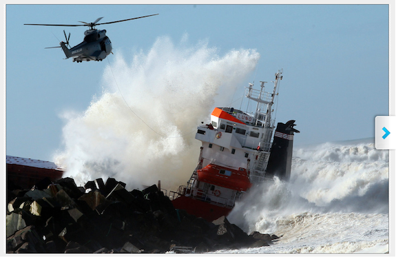
ANGLET, France (AP) - A military helicopter evacuated the crew of a Spanish cargo ship that slammed into a jetty and split in two in choppy Atlantic Ocean waters off southwestern France on Wednesday.


Spanish Cargo Ship Breaks Into Two After Washing Up on French Coast


The hold of the 100-meter-long ship, the Luno, was empty when the accident occurred along the coast of the town of Anglet, and a small amount of fuel was spilling into the water, officials said. The ship, which typically carries fertilizer, had been heading to a nearby port to load up with cargo when its engine broke down and the rough waves carried it into the jetty.

Share this on Facebook?

PHOTOS ON SKYE: Brutal Waves Split Cargo Ship in Half
France Cargo Ship AccidentThe cargo ship's stern half drifted onto the shore, while the bow remained stuck on the rocky jetty. Images on i-Tele cable news channel showed a man dangling from a rescue helicopter as the ship, pinned to the rocks, was ripped asunder by one massive wave.

Veronique Bordenave, a spokeswoman for the regional government, said the 12-man crew was evacuated, and rescue vehicles were on site to provide medical care. Anglet City Hall spokesperson Liane Beobide said one of the crew members had sustained a broken nose, but there were no other injuries reported.

Frederic Cuvillier, France's junior minister for transportation, seas and fishing, was heading to the site, his office said.

Southwestern Europe, including France's western coast, has been battered by high winds and waves in recent days.

PHOTOS ON SKYE: Brutal Waves Split Cargo Ship in Half
Spanish cargo ship accident


Permalink | Email this | Linking Blogs | Comments

Photos: Is Sochi Ready for the Olympic Games?

Look: Mars Curiosity Rover Takes Its First Photo of Earth

$
0
0
Thursday, Jan. 6, 2014

What would Earth look like if you were on Mars? Turns out it would look a lot like Mars does from Earth.

This photo - the first taken of Earth by the Curiosity rover - shows Earth as just a speck in a vast sea of stars. The image also includes a silhouetted Martian landscape. It's a stunning shot. The photo was captured Jan. 31, 2014, and was released today. It was processed, according to NASA, "to remove the effects of cosmic rays."

Space agency officials say a human on Mars could easily spot Earth and our moon with the naked eye. We can't help but wonder: How long will it be before someone lands on Mars and does just that?

SEE ON SKYE: 12 Stunning Photos of Mars


Permalink | Email this | Linking Blogs | Comments


Photos: Brutal Waves Tear Spanish Cargo Ship in Half

Rare Snowstorm Hammers Western Oregon

$
0
0
Updated Thursday, Jan. 6, 2014, at 7:34 p.m. ET
Traffic is backed up on Interstate 5 South after a multiple-vehicle crash near Albany, Ore., on Thursday, Feb. 6, 2014. Oregon's dry winter was interrupted Thursday by a storm that was expected to drop snow throughout the state, with as many as nine inches accumulating in the central Willamette Valley. Stormy conditions early in the day snarled traffic on Interstate 5 around Salem and Albany. (AP Photo/Statesman-Journal, Danielle Peterson)
Traffic is backed up on Interstate 5 South after a multiple-vehicle crash near Albany, Ore., on Thursday, Feb. 6, 2014. (AP Photo/Statesman-Journal, Danielle Peterson)

PORTLAND, Ore. (AP) - A rare snowstorm hammered parts of the Pacific Northwest on Thursday, leaving one person dead in a massive traffic pileup on Interstate 5, causing multiple other wrecks, and closing schools and offices.

Forecasters said several inches of snow could fall in Oregon's Willamette Valley before the storm is over. The central part of the valley - near Corvallis and Albany - could see up to a foot of snow.

The big pileup on I-5 that killed one person and injured others occurred across the Columbia River in Washington state's Clark County.

At least half a dozen tractor-trailers were involved in the collision on the snow-covered freeway. The massive pileup happened around 10 a.m. near milepost 13, the Columbian reported.

Washington State Patrol Trooper Steve Schatzel said several people were trapped in the wreckage. One suffered injuries described as critical and two others suffered serious injuries. The exact number of people injured was not available Thursday afternoon.

The snowstorm also caused a 25-vehicle pileup on I-5 near Albany.

"It's pure chaos," Oregon State Police Lt. Steve Mitchell said as troopers struggled to reach trucks and cars that crashed along the freeway. "For all intents and purposes, it's shut down between Albany and Salem."

Traffic backed up for miles. A detour was set up, and a wreck blocked that route for a time, as well.

By mid-afternoon, crews had opened one lane of traffic, but the state Department of Transportation said traffic was still slow.

Only minor injuries were reported.

Oregon's largest city, Portland, was getting hit hard in snow Thursday afternoon. Cars were slipping and sliding as commuters left work early.

A blizzard warning was posted for the Columbia Gorge, an hour east of Portland.

The storm struck quickly Thursday morning, dumping an estimated 3 to 5 inches in the Albany region and then spreading north.

Transportation officials urged motorists to stay off highways if possible to avoid the kind of traffic nightmare that occurred in Atlanta last week, when thousands of motorists were stranded.

National Weather Service forecasters said the storm will be the most widespread snow event in the northern and central Willamette Valley since December 2009.

The storm is developing, as moisture from the coast collides with an arctic air mass over the state. The cold is expected to last through the weekend, and a mix of snow and freezing rain could accompany moderating temperatures.

RELATED ON SKYE: 50 Incredible Photos of Forces of Nature
Volcano Eruption


Permalink | Email this | Linking Blogs | Comments

Weekend Snow to Coat Portions of the Midwest, East

$
0
0

Updated Friday, Feb. 7, 2014, 6:09 p.m. ET
Winter Weather Massachusetts
Peggy Udden of Norwood, Mass., shovels her driveway in Norwood, Wednesday, Feb. 5, 2014. (AP Photo/Steven Senne)

While a blockbuster snowstorm highly unlikely in the Midwest, the mid-Atlantic and New England this weekend, some snow is still in the offing.

The setup is rather complex. Instead of one major storm affecting the region, there will be smaller, fast-moving storms that can produce light snowfall. Essentially, the storms will compete with each other.

According to AccuWeather.com Winter Weather Expert Brian Wimer, "Even with the weaker storms, in some communities, there will still be snow to shovel, roads to treat and travel delays this weekend, centered on the Midwest and Northeast."

Dry air in the lowest layers of the atmosphere over the Northern states will work against a heavy snowfall.

"The dry air may prevent snowfall entirely in some communities this weekend, despite the passage of the storms," Wimer said.

One storm will attempt to push a batch of snow northward along the East Coast on Saturday.

Weekend Storms

Snow will reach the southern Appalachians from the same system on Saturday, after affecting part of the Tennessee Valley Friday night.

A little snow can fall on Washington, D.C., Baltimore and Philadelphia on Saturday and could reach as far north as New York City and Long Island Saturday night.

Farther west, a second storm will push across the Midwest Saturday into Sunday.

Weekend Storms

This second system will bring light snow to Chicago, Milwaukee, Indianapolis, Detroit, Cincinnati, Cleveland, Pittsburgh, Des Moines, Iowa, and Omaha, Neb.

The second storm will struggle to bring snow east of the Appalachians on Sunday.

RELATED:
AccuWeather.com Winter Weather Center
Latest Watches, Warnings, Advisories
Snow to Head to Seattle, Portland; Needed Rain for California

More Storms

According to Senior Meteorologist Henry Margusity, "The weekend storms will not mark an end to the stormy pattern. Additional storms are on deck through at least the middle of February."

A fast-moving storm is being watched for a streak of snow over part of the Ohio Valley Sunday night and the mid-Atlantic on Monday.

Another, larger and slow-moving storm may affect part of the eastern third of the nation with snow, ice and rain on or just before Valentine's Day.

According to Senior Meteorologist Mark Mancuso, "The storm later next week has the potential to cause major problems with snow and ice in the South."

As the storms move inland from the Pacific Ocean, they will have access to moisture from the Gulf of Mexico and perhaps the Atlantic Ocean before heading out to sea. If any of these storms are able to slow down and strengthen, they have the potential to grab the moisture and unleash heavy precipitation.

The stormy pattern will have impact in the West.

Storms moving in from the Pacific Ocean are scheduled to drop heavy rain and several feet of snow in parts of California, Oregon and Washington into next week.

The moisture is desperately needed in parts of the West.

RELATED ON SKYE: The 10 Snowiest Places on Earth


Read | Permalink | Email this | Linking Blogs | Comments

Five Foods That Can Help Keep You Warm This Winter

$
0
0
Friday, Feb. 7, 2014

Ginger carrot soup. (Photo courtesy of Healthy Eating Starts Here)

As the arctic air keeps on bringing brutal temperatures to a large part of the United States, people can do more to keep warm besides wearing a coat, hat and gloves.

A variety of foods can help the body stay warm during these winter months. Heather Nicholds, a holistic nutritionist who has the Healthy Eating Starts Here website, said grains, spices and oils give the body energy to keep warm.

1. Ginger

Ginger not only helps the body stay warm, but it also helps boost the immune and digestive systems.

Ginger can be used in salad dressings, soups, such as ginger carrot soup, and baked goods. You can even drink ginger in hot water.

2. Coconut Oil

Fats in general, such as coconut oil, keep the body warm through metabolizing, Nicholds said.

Coconut oil can also be used as a moisturizer, which will prevent the body from losing heat through dry skin, she said.

3. Cinnamon and other spices

You don't want things too spicy because spices such as cayenne can make you sweat and cause you to lose heat, Nicholds said.

Cinnamon, cumin, paprika, nutmeg and allspice help increase the body's metabolism and generate heat.


Spiced Hot Chocolate. (Photo courtesy of Healthy Living Starts Here)

4. Whole grains

Oatmeal isn't just a breakfast food. It can be used to add whole grains to dinner such as a savory balsamic oatmeal.

Eaten hot, rolled oats, brown rice, millet and other whole grains give immediate warmth and also provide needed complex carbohydrates to fuel the body's engine.

Nicholds said the grains are a good source of B vitamins and magnesium, which help the thyroid and adrenal glands better regulate the body's temperature during a time when they slow down from the colder weather.


Savory Balsamic Oatmeal. (Photo courtesy of Healthy Eating Starts Here)

5. Hot soups

Hot soups seem obviously for the winter months, but the timing of the foods are important, too, Nicholds said.

A salad, for instance, can be eaten during the afternoon, when the body is at its warmest.

But a stew or a soup, such as a chickpea tomato soup, in the evening can help keep the body warm through the night.


RELATED ON SKYE: 22 People More Sick of Winter Than You Are


Read | Permalink | Email this | Linking Blogs | Comments

Utilities Scramble to Restore Power in US

$
0
0
Updated Friday, Feb. 7, 2014, 5:34 p.m. ET
Winter Weather
An ice covered utility line blocks the path of a firetruck after a winter storm Wednesday, Feb. 5, 2014, in Philadelphia. (AP Photo/Matt Rourke)

PHILADELPHIA (AP) - A small army of electricity restoration crews labored Friday to reconnect nearly 300,000 customers in Pennsylvania and Maryland, and utility companies warned some will have to wait several more days.

The lion's share of the outages remained in the Philadelphia suburbs, where many schools were closed for a third day, and a PECO spokesman said work was continuing around the clock. PECO accounted for about 250,000 outages late Friday afternoon.

"That number is coming down throughout the course of the day," said PECO spokesman Fred Maher. "We are preparing people for the fact that some folks will be without power over the weekend."

Severe cold weather that gripped the mid-Atlantic on Friday was expected to remain in place for days, and forecasters said light snow was possible over the weekend.

Utility companies reported about 280,000 customers without power in Pennsylvania - most of them in the five-county Philadelphia area. In Maryland, service has been restored to all but about 16,000 homes and businesses.

There has been progress - more than a million total outages had been attributed to the storm.

Systems engineer John Bowman said he has been buying $6 packages of firewood at a neighborhood hardware store, planning to burn them in the coming days to keep the temperature in his Downingtown home high enough to prevent damage to water pipes. He said he was told it may be Sunday before his power is restored.

"With the way the sun's been warming up the house, I don't want to use those rations yet," Bowman said.

Rachel Ezekiel Fishbein of Elkins Park lost power before dawn Wednesday, a day after she spent about $300 on groceries in anticipation of the storm. Although she tried to save some perishables by packing them outside in a cooler in the snow, she wasn't optimistic on Friday morning.

"I'm thinking that most of that food has probably gone bad by now," Fishbein said from her sister-in-law's house.

Authorities urged people to be careful when using space heaters and other methods to heat their homes. The Pennsylvania Emergency Management Agency said four confirmed cases of carbon monoxide poisoning, and a fifth suspected case, were reported at a hospital in the Philadelphia suburbs on Wednesday night.

The Bucks County Courier Times also reported that one person was taken to a hospital by helicopter and several others were sickened in a carbon monoxide incident Thursday night in the suburban town of Horsham. The paper also reported a fire emergency call Thursday from someone who took his barbecue grill inside for warmth.

Amtrak restored full service between Philadelphia and Harrisburg on Friday morning after tracks were cleared of fallen trees and debris.

The storm that generated headaches for motorists and homeowners also created a boom in business for Amspacher Tree Service in York, where the ice coated snowy trees and forced down branches. The company was concentrating on getting trees off of homes and cars, and telling customers their crews will return later to clean it all up.

"We're going pretty crazy," said Louanna Amspacher. "We went from a dozen calls a day, at most, to a hundred calls."

PHOTOS ON SKYE: Winter Storm Hits from Midwest to Northeast
Kansas Winter Storm Photos


Permalink | Email this | Linking Blogs | Comments

Weather-Weary Nation Asks Why Such a Nasty Winter

$
0
0
Friday, Feb. 7, 2014
NYC Winter Weather
Pedestrians make their way through a slush and water at an intersection in New York, Wednesday, Feb. 5, 2014. (AP Photo/Seth Wenig)

WASHINGTON (AP) - Cold and snow keep battering the Midwest and East, and even Atlanta was temporarily paralyzed. California has been bone dry. Alaska set heat records.

The wild winter somehow became even more wicked Thursday morning when the national average temperature plunged to a brutal 11 degrees - the lowest temperature of a season of extremes.

A weather weary nation asks a simple question: Why?

The answer is the jet stream, the river of air that dictates our weather. Normally the jet stream stays in Canada or the northern U.S., going west to east in a somewhat straight line. But this winter it has plunged south, creating high pressure ridges and low pressure troughs and taking cold polar air south and east and leaving warm, dry weather to the west.

"We are having an unusual jet stream that's giving us crazy cold weather in the East and the ridiculously resilient ridge as it's called in California," said Weather Underground meteorology director Jeff Masters.

Q: Why is the jet stream doing this?

A: There are three different forces probably at work here, but scientists still need to do more research, said Derek Arndt, of the National Climatic Data Center in Asheville, N.C. One is just the random natural variability of daily weather. Another is a mid-length weather feature called the Pacific Decadal Oscillation - think of it as a cousin of El Niño - that warms the northern Pacific and helps push the jet stream south. And finally, a new and controversial theory is that a warmer Arctic region and shrinking summer sea ice from man-made global warming has shifted jet stream patterns, making it wavier and bringing more unpredictable weather.

Q: Is it unusual for the weather pattern to last this long?

A: It doesn't happen often, but it's not that unusual either, said Bruce Terry, of the National Weather Service's Weather Prediction Center in College Park, Md.

Q: So how cold was Thursday?

A: The national average temperature of 11 degrees is the coldest of this winter and will likely be the coldest of the season, according to calculations by Weather Bell Analytics meteorologist Ryan Maue. It was computed from temperatures at 7 a.m. EST in the Lower 48 states.

The lowest was minus 34 in Montana and several areas were minus 20, according to the National Weather Service.

Q: Has this been a record winter?

A: No. Given the unusual heat in the West and the cold in the East, they almost balance each other, Masters and Arndt said. So when the final monthly statistics come out, January in the U.S. won't be near record cold.

"When you compare it to the 20th century, it was still cold, but not dramatically cold," Arndt said.

Q: Was this just a U.S. thing?

A: No. Parts of South America and Australia have had much warmer than normal weather. Parts of Europe have been cold and stormy, others record warm. For much of January, Greenland was 8 degrees warmer than normal.

Q: When will it end?

A: Soon enough. In Northern California, heavy rains are coming. A predicted eastern winter snowstorm this weekend is looking less mighty than it did a few days ago. It's not soon enough for the meteorologists who predict it.

"I'm sick of it," said the weather service's Bruce Terry.

RELATED ON SKYE: 22 People More Sick of Winter Than You Are


Permalink | Email this | Linking Blogs | Comments

More Snow to Hit Oregon; Needed Rain for California

$
0
0
Updated Friday, Feb. 7, 2014, 6:42 p.m. ET
Oregon Snowstorm
This image provided by the Oregon Department of Transportation shows a multi-car pileup Thursday Feb. 6, 2014, near Albany, Ore. (AP Photo/ Oregon Department of Transportation)​

Storms will bring both slippery travel to the Northwest and needed moisture to the much of the West in general in the coming days.

While winter has been in full swing across the eastern two-thirds of the nation since late November, the West Coast has had a hard time finding much in the way of extreme cold or snow. A change is already underway for the West.

A series of storm systems from the Pacific Ocean will not only reach the California, Oregon and Washington coasts through this weekend and into next week, but they will bring heavy precipitation.

Enough cold air will be in place to bring snow not only to the Sierra Nevada and Cascades, but also to areas along the coast in the Northwest. Pockets of heavy snow will extend well inland as far as the Colorado Rockies.

Weekend Storms

The greatest amount of snow and rain will be focused from northern California to southern Washington border through the weekend.

Rounds of wintry precipitation will fall around Portland, Ore., into Sunday. Initially, snow will fall, but a transition to ice and later cold rain will occur over the weekend. There is the potential for a heavy amount of snow and ice.

RELATED:
AccuWeather.com Winter Weather Center
Latest Watches, Warnings, Advisories
Snow to Head to Seattle, Portland; Needed Rain for California


Accompanying the snow will be strong winds from the east blowing through the Columbia River Gorge as high pressure funnels cold air toward the coast.

West Coast Storms

Areas such as Troutdale, Multnomah Falls, Cascade Locks and Corbett, all in Oregon, will likely endure blizzard conditions and very difficult travel at times into Saturday.

Those expecting to travel on I-84 through the Gorge should be prepared for very hazardous conditions, such as blinding snow, whiteouts, extreme cold, road closures and the possibility of becoming stranded.

Enough snow to shovel and plow are forecast around the Oregon Route 97 corridor and The Dalles and Bend, Ore. Some locations in this swath will receive over a foot of snow.

Similarly, those who will head south on I-5 will need to be ready for slippery and dangerous road conditions, especially when traveling through higher elevations south of Eugene.

Dry air to the north will slow the northward advance of the snow. As a result snow is a touch call around the Seattle, Wash., metro area with the greatest chance of a couple of inches toward Tacoma, Wash. Any precipitation that falls beyond the day Sunday is likely to fall as rain along the coast.

West Coast Storms

RELATED:
AccuWeather.com Winter Weather Center
MAP: Current Weather Watches, Warnings and Advisories
Widespread Weekend Snow to Snarl Travel in Rounds for Midwest, East


Snowfall in Portland through this weekend will average 4 to 8 inches with the chance of sleet and freezing rain mixing in Saturday night. In the Oregon Cascades, snowfall of several feet are forecast.

Much-Needed Rain, Snow to Reach California

Farther south into California, rounds of heavy rain and snow will fall into early next week.

Cumulative snowfall accumulations will generally range from a few inches in the elevations above 5,000 feet to several feet over peaks and ridges.

According to Western Weather Expert Ken Clark, "In the Sierra Nevada, elevations above 7,500 feet will pick up between 3 and 6 feet of snow through Sunday."

In terms of the ongoing drought that has gripped parts of the West for years, the moisture with this system will only make a dent in the huge precipitation deficit that has occurred.

Drought

In many areas along the West coast, anywhere from 18 to as much as 36 inches of rainfall is needed to bring an end to the drought, and that does not appear likely in the pattern.

The storms will bring episodes of strong winds in the mountains.

"From later Friday through Sunday, wind gusts in the Sierra Nevada will range between 40 and 80 mph with gusts to near 100 mph over the ridges," Clark said.

However, the rain and snow will bring some short-term benefits.

The rain will dampen the landscape and reduce the wildfire threat. It will also bring a boost to ski resorts in the region. It may be enough to put some water back into area streams. As much as 6 inches of water may be locked up in the snowfall over the mountains, which will be released in the spring.

Occasional rain is in the offing for Monterey, Calif., and the Pebble Beach Pro-Am through this weekend. Temperatures will be mainly in the 50s.

One or two rounds of rain will reach Southern California, including Los Angeles and San Diego, but that rainfall will be light and spotty. Enough rain can fall to briefly dampen the landscape.

The rain can also make road surfaces slick, when combined with oil residue.

RELATED ON SKYE: 50 Incredible Photos of Forces of Nature
Volcano Eruption


Permalink | Email this | Linking Blogs | Comments


Watch: Snow Plow Slams Unsuspecting Man With Wall of Snow

$
0
0
Friday, Feb. 7, 2014


This unfortunate pedestrian was hit with an unpleasant surprise early Wednesday morning. The poor guy was walking down Brooklyn's Coney Island Avenue, minding his own business when - bam! - a wall of snow knocked him off his feet.

A camera at a nearby car dealership caught the whole scene on video. According to the YouTube post, employees at JM Legend Auto arrived at work to find a broken glass door and snow inside the showroom.

Luckily the man didn't seem hurt; he can be seen getting back up after the plow passes.

RELATED ON SKYE: 50 Must-See Weather Photos from 2013
Twin Waterspouts


Permalink | Email this | Linking Blogs | Comments

Look: Astronaut Snaps Incredible Photo of Rocket Launch from Space

$
0
0
Friday, Feb. 7, 2014

An astronaut aboard the International Space Station snapped this incredible photo yesterday moments after a rocket launch in South America.

The Ariane 5 rocket was launched from the European Space Agency's spaceport in French Guiana and was carrying a communications satellite into orbit.

Mastracchio captured the scene moments after launch and posted the photo to Twitter, writing, "The contrail of the Ariane 5 from French Guiana as seen from the ISS just a few minutes ago."

Stunning.

RELATED ON SKYE: 25 Amazing Photos of the International Space Station
International Space Station, Shuttle


Permalink | Email this | Linking Blogs | Comments

Photos: Winter Olympics Kick Off in Sochi, Russia

Tokyo Hit by Rare Snowfall, Trains Delayed

$
0
0
Saturday, Feb. 8, 2014

Visitors walk in the snow at Enoshima Shrine in Fujisawa, near Tokyo, Saturday, Feb. 8, 2014. The Japan Meteorological Agency issued the first heavy snowfall warning for central Tokyo in 13 years. (AP Photo/Shizuo Kambayashi)

TOKYO (AP) - The Tokyo area was hit by a rare heavy snowfall Saturday, stalling trains, grounding flights, and blanketing roads and skyscrapers with snow.

By mid-afternoon, around 4 inches of snow had fallen.

The Japan Meteorological Agency issued its first heavy snowfall warning for central Tokyo in 13 years. It warned that snow and rain would continue through the night, but that skies would clear gradually Sunday.

Several universities in Tokyo delayed the start of entrance exams because of delays in metropolitan trains and subways, known for almost always being on time.

Major carriers Japan Airlines and All Nippon Airways suspended domestic flights from Tokyo's Haneda airport. Some bullet trains were delayed and parts of expressways were closed.

Japanese media said dozens of injuries were being reported from people slipping and falling, or crashing their cars.

RELATED ON SKYE: The 10 Snowiest Places on Earth


Permalink | Email this | Linking Blogs | Comments

Weekend Snow in Store for Parts of the Midwest, East

$
0
0
Saturday, Feb. 8, 2014

In this file photo, a woman shovels her car out from snow on East Concord Street in the South End after a winter storm in Boston. More snowstorms are on their way to New England. (Darren McCollester/Getty Images)

While a blockbuster snowstorm is highly unlikely in the Midwest, the mid-Atlantic and New England this weekend, some snow is still in the offing.

The setup is rather complex. Instead of one major storm affecting the region, there will be smaller, fast-moving storms that can produce nuisance snowfall. Essentially, the storms will compete with each other.

According to AccuWeather.com Winter Weather Expert Brian Wimer, "Even with the weaker storms, in some communities, there will still be snow to shovel, roads to treat and travel delays this weekend, centered on the Midwest and Northeast."

Dry air in the lowest layers of the atmosphere over the Northern states will work against a heavy snowfall.


"The dry air may prevent snowfall entirely in some communities this weekend, despite the passage of the storms," Wimer said.

One storm will continue to push a batch of snow from the western Tennessee Valley to the mid-Atlantic through early Saturday evening.

RELATED:
AccuWeather.com Winter Weather Center
Latest Watches, Warnings, Advisories
Next Week's Winter Storm Could Signal a Pattern Change


A little snow can fall on Washington, D.C., Baltimore and Philadelphia on Saturday and could brush New York City and Long Island Saturday evening. Little, if any, snow accumulation is expected in these I-95 cities.

Farther west, a second system will push across the Midwest Saturday into Sunday.

This second system will bring light snow to Chicago, Milwaukee, Indianapolis, Detroit, Cincinnati, Cleveland, Pittsburgh, Des Moines, Iowa, and Omaha, Neb.


The second storm will bring more nuisance snow to the Northeast Sunday through Sunday night.

Between the two weekend systems, the second has the greater opportunity to deliver a coating to an inch of snow to the I-95 corridor from Philadelphia to New York City to Boston.


More Storms

According to Senior Meteorologist Henry Margusity, "The weekend storms will not mark an end to the stormy pattern. Additional storms are on deck through at least the middle of February."

A fast-moving storm is being watched for a streak of snow over part of the Ohio Valley Sunday night and the mid-Atlantic on Monday.

Another, larger and slow-moving storm may affect part of the eastern third of the nation with snow, ice and rain on or just before Valentine's Day.

According to Senior Meteorologist Mark Mancuso, "The storm later next week has the potential to cause major problems with snow and ice in the South."

As the storms move inland from the Pacific Ocean, they will have access to moisture from the Gulf of Mexico and perhaps the Atlantic Ocean before heading out to sea. If any of these storms are able to slow down and strengthen, they have the potential to grab the moisture and unleash heavy precipitation.

The stormy pattern will have impact in the West.


Storms moving in from the Pacific Ocean are scheduled to drop heavy rain and several feet of snow in parts of California, Oregon and Washington into next week.

The moisture is desperately needed in parts of the West.

PHOTOS ON SKYE: Winter Storm Hits from Midwest to Northeast
Kansas Winter Storm Photos


Permalink | Email this | Linking Blogs | Comments
Viewing all 4069 articles
Browse latest View live


Latest Images