Quantcast
Channel: SKYE on AOL
Viewing all 4069 articles
Browse latest View live

Next Significant Northeast Snow Threat to Occur Monday

$
0
0

Thursday, Jan. 23, 2014
Winter Weather Mass
A passer-by walks through snow and strong wind along an empty street in Marshfield, Mass., Wednesday, Jan. 22, 2014. (AP Photo/Steven Senne)

The next storm that has a chance of bringing accumulating snow to a large part of the Northeast is scheduled for Monday, Jan. 27, 2014.

The train of Alberta Clipper storms that began a couple of weeks ago will continue into next week. The storms originate from the western provinces of Canada, where they get their name.

The pattern will have yielded close to a dozen systems by this weekend. The clipper storms have been of various strength and have taken a variety of paths.

After a large and strong clipper storm blasts the Great Lakes with wind, snow and whiteouts Friday night into Saturday night, the next clipper storm will take a path farther south.


It is possible the track of the storm and its snow may shift to the north or to the south as more information becomes available.

The clipper scheduled to take a track across the Ohio Valley Sunday night will reach the mid-Atlantic coast on Monday. The snowfall output from the storm could be similar to the storm from this past Tuesday.

The exact track and strength of the Monday storm will determine how much snow falls and where the cut off of band of snow exists to the north and south.

RELATED:
Will It Snow on Feb. 2 in East Rutherford, N.J.?
Temperature Forecast Maps
Winter Weather Center

However, at this early stage, the indications are there is at least a chance of accumulating snow and slippery travel bounded by North Carolina to the south and Pennsylvania, New York state and southeastern New England to the north.

Yet another clipper storm may take a similar path a day or two prior to the big game at East Rutherford, N.J.

Details on the track and intensity of the snow and the extent of disruptions to travel and other daily activities will become available this weekend on AccuWeather.com.

PHOTOS ON SKYE: Heavy Snow Falls Across Eastern U.S.
Snow Storm New York


Read | Permalink | Email this | Linking Blogs | Comments


Bangkok Temperature Hits 30-Year Low

$
0
0
Thursday, Jan. 23, 2014
modern town in bangkok beside...
Bangkok (Shutterstock)

BANGKOK (AP) - Thailand's capital has seen its coldest temperatures in three decades, as the normally balmy Southeast Asian country is experiencing one of its longest winter cold snaps in years.

Oparg Karankawinpong, deputy director of the Department of Disease Control, said Thursday that as many as 63 people in 24 provinces have died from cold-related ailments since the cool season began in late October, with the north and northeast being the country's chilliest areas. He said hotter weather was expected to begin in mid-February.

Thai media quoted Songkram Aksorn, deputy director general of the country's meteorological department, as saying that Bangkok's temperature fell Thursday morning to 15.6 degree Celsius (60.08 degrees Fahrenheit), the lowest in 30 years. He added that the current cold season lasting almost three months was the longest in a decade.

It is not unusual for people living in northern Thailand to haul out coats and scarves to wear around the turn of the year, and tourists and locals alike wonder at frost found in mountainous areas. But in poorer communities it is necessary for blankets to be distributed by authorities. The cold weather also is a concern because it lowers people's resistance to diseases, raising the risk of infections such as bird flu.

RELATED ON SKYE: Off-the-Charts Hottest and Coldest Places on Earth


Permalink | Email this | Linking Blogs | Comments

Snowstorm Gives MetLife Stadium Dress Rehearsal

$
0
0
Thursday, Jan. 23, 2014
Winter Weather Super Bowl Football
Snow is accumulated on the seats and on the field of MetLife Stadium as crews removed it ahead of Super Bowl XLVIII following a snow storm, Wednesday, Jan. 22, 2014, in East Rutherford, N.J. (AP Photo/Julio Cortez)

EAST RUTHERFORD, N.J. (AP) - The NFL and personnel at MetLife Stadium had a Super Bowl pop quiz on snow removal less than two weeks before the title game between the Denver Broncos and Seattle Seahawks.

The league and stadium officials decided to use a winter storm that dumped a foot or more of snow in the New York City metropolitan area Tuesday as somewhat of a dress rehearsal to see how quickly they could clean the 80,000-seat facility that will hold the first outdoor Super Bowl in cold weather.

NFL executive vice president Eric Grubman said Wednesday an 18-hour time limit was set for removing the snow from the stadium, surrounding parking lots and access roads in the Meadowlands sports complex, where the game will be played Feb. 2.

Grubman refused to speculate whether the storm that snarled roads, closed schools and had states of emergency in New Jersey, New York City and some surrounding areas would have caused the Super Bowl to be postponed. He said that would be a decision made by state authorities.

Grubman, however, said the league has several contingency plans for the game, including moving it up to Friday or Saturday, pushing it back to Monday or adjusting the scheduled start on Sunday deal with the weather. The game is scheduled to start at 6:25 p.m. EST.

"Based on the long-range forecast, all that I would even hazard to guess is that it is probably going to be cold. I doubt we are going to have an unusual warm spell," Grubman said at the news conference originally called to showcase how the stadium was preparing for the Super Bowl.

The snowstorm on Tuesday was a fortuitous coincidence for the cold-weather Super Bowl.

MetLife spokeswoman Nicole Fountain said the stadium and its contractors had 1,300 workers removing the 13 inches of snow that fell in and around the stadium. The crews started removal at around 8 a.m. and had sections of the stadium and most of the tarp-covered field cleared by noon.

During this past season, the crews removed six inches of wet, iced-packed snow in roughly 12 hours before a Seahawks-Giants game on Dec. 15, Ron VanDeVeen, the stadium's senior vice president of events said Wednesday. The snow being removed Wednesday was not as heavy, he said.

Grubman said the league is prepared to play the game even if there is still some snow in the stands.

"Games are played with snow all the time," he said. "It's not just MetLife Stadium. I think the crowd will be an exceptional crowd and they will enjoy the game. I don't think they will be fazed by a little bit of snow on their seats, if that's what comes to pass. We aim to not have that happen, but if it happens, it's sort of what happens in NFL stadiums all the time."

Grubman also displayed warm welcome kits that fans will receive entering the stadium on game day. Cushions hold the kit items which included ear and hand muffs, mittens, a hat, neck warmers, lip balm and other items.

"The warm welcome kit was designed to make fans comfortable," he said, "and to have those last-minute items that they may not think about."

Grubman also advised fans to dress in layers for the game. He said there will be warming areas in the stadium should anyone need them.

The storm that hit the area Tuesday stretched from Kentucky to New England.

"If you are going to have one, and you are going to have it 10 days out, we're going to make use of it," Grubman said of the storm. "The silver lining is we are running ourselves through a rigorous dress rehearsal."

Grubman said the league was gathering information from law enforcement authorities about how the emergency conditions might have affected the game had it been played Tuesday. The two groups will go over the information soon.

Whatever happens, the league is ready to deal with all scenarios, Grubman said.

"Some people will say perfection will be a nice little dusting of snow in the third quarter," Grubman said. "Other people will say perfection will be 40 degrees in early February with the sun shining until sundown at 5:35 or 5:45 or 6:20 on Sunday, the second.

"I think it is really up to the individual."

RELATED ON SKYE: 20 Photos of Monster Blizzards


Permalink | Email this | Linking Blogs | Comments

Go Figure: Alaska Is Warmer Than Lower 48

$
0
0
Thursday, Jan. 23, 2014
Mount McKinley
Mount McKinley provides a dramatic skyline, in a view from Kincaid Park in Anchorage, Alaska. (AP Photo/Dan Joling)

WASHINGTON (AP) - The weather seems more than a bit upside down.

The average temperature for the Lower 48 states midmorning Wednesday was a chilly 22 degrees. The average temperature for the entire state of Alaska at the same time was 24 degrees, according to calculations by Weather Bell Analytics meteorologist Ryan Maue.

Parts of Alaska were 30 degrees warmer than normal, southeastern Alaska hit 57 earlier in the week and the forecast for the rest of week was more unseasonable warmth, said National Weather Service climate science manager Rick Thoman in Fairbanks. He said it's possible that the state record January high of 62 could be broken later this week.

Atlanta dropped to 16, Washington, D.C., to 9 and Central Park in New York fell to 7 on Wednesday.

The jet stream - the river of air that dictates much of America's weather - is meandering again, said Jeff Masters, meteorology director at Weather Underground. So warm air is flowing from near Hawaii north to Alaska and from Canada south to the Lower 48.

"It's kind of something we've seen a lot of lately," Masters said. "You get major kinks in the jet stream. You get warm air where you don't usually see it in the north and cold air where you don't see it very often in the south."

So far this month, weather stations in the Lower 48 have broken or tied more than 2,600 records for cold, while Alaskan weather stations have broken or tied more than 20 daily temperature records for warmth. Alaska's relative warmth has shut down ski slopes and caused road problems.

"This is not the kind of weather most Alaskans like," Thoman said. "We'd be happy to swap."

RELATED ON SKYE: The 10 Snowiest Places on Earth


Permalink | Email this | Linking Blogs | Comments

LOOK: Bare Mount Shasta Reveals California Drought Severity

$
0
0

Images of a nearly bare Mount Shasta taken from space reveal the severity of the California drought.

The volcanic peak, normally blanketed in snow this time of year, has almost no snow cover on the south, west and eastern slopes. Snow cover has decreased dramatically since November, when the mountaintop looked mostly white, NASA's Earth Observatory reported.

Normally, snow cover peaks around April 1, and by the first of the year, 15 to 30 percent of that snow has already accumulated.

"The Shasta snow cover reflects two dry winters (in 2012 and 2013), plus a December 2013 snowfall that puts the area less than 5 percent of the way toward the April 1 average," Roger Bales, a hydrologist at the University of California-Merced, told the Earth Observatory. Right now, snow cover may even be below the permanent snow line, Bales said.


Mt. Shasta in November 2013 had less snow than usual. (Credit: NASA Earth Observatory images by Robert Simmon, using Landsat 8 data from the USGS Earth Explorer)

The images were captured using the Operational Land Imager (OLI) on the Landsat 8 satellite.

The volcanic slopes are a popular destination for skiers and other winter sports enthusiasts. But this year, with just 2 to 3 inches (5 to 7.5 centimeters) of the white stuff on the ground, most ski lifts were closed on Jan. 16, according to the Earth Observatory. Die-hard skiers had to hike up a few glaciers to get their fix.

But a depressing ski season is the least of California's worries. Snowpack provides the water supply for many parts of the state, meaning water shortages could be imminent.

The Colby Wildfire burning near Los Angeles likely took hold because of the unusually parched conditions this winter. And the drought, which is gripping much of the Western United States, could also threaten crop yields.

"Precipitation in some areas of the state is tracking at about the driest year of record," the California Department of Water Resources reported on its website, as quoted by the Earth Observatory.

"On average," the observatory quoted, "about half of California's statewide precipitation occurs in December, January and February, with only a handful of large winter storms accounting for the difference between a wet year and a dry one."

Follow Tia Ghose on Twitter and Google+. Follow LiveScience @livescience, Facebook & Google+. Original article on LiveScience.

Copyright 2014 LiveScience, a TechMediaNetwork company. All rights reserved. This material may not be published, broadcast, rewritten or redistributed.

RELATED ON SKYE: 7 Surprising Health Effects of Drought


Permalink | Email this | Linking Blogs | Comments

Photos: Christ the Redeemer Statue Under Repair After Lightning Strike

Stephen Colbert: 'Mars Has Doughnuts!'

$
0
0
Thursday, Jan. 23, 2014


We reported this week that NASA scientists discovered a rock on Mars resembling a jelly doughnut. Stephen Colbert, for one, is pretty excited about the discovery.

"Mars has doughnuts!" he declared on The Colbert Report. "Finally. We've waited so long for this. We have finally found a habitable planet. Call off the search for water and start looking for a lake of Coolatta."

Watch the video for Colbert's hilarious interpretation of the news. Of course, scientists have at least one explanation for the rock's sudden appearance in a place where it wasn't seen in an earlier photograph.

Reported the Associated Press: "Chief scientist Steve Squyres ... said in a presentation last week that one of Opportunity's wheels probably kicked up the rock, which then slid into its field of view."

SEE ON SKYE: 21 Awe-Inspiring Spacewalk Photos


Permalink | Email this | Linking Blogs | Comments

Watch: Paraglider Performs Insane Tricks

$
0
0

Jean-Baptiste Chandelier knows what it's like to fly. The 28-year-old French paragliding pilot and filmmaker has been practicing the sport since he was 19. In his most recent video, Chandelier soars over land and water, performing some crazy tricks - including one especially mind-blowing feat on top of a tour bus - that he makes look easy. Chandelier filmed the movie over the course of a year, traveling across Europe from the French Alps to the Greek islands.

RELATED ON SKYE: 10 Amazing Photos of Wingsuit Flying
Wingsuit Flying


Permalink | Email this | Linking Blogs | Comments


The World's Most Extraordinary Private Island Resorts

Massive Pileup on I-94 Kills 3, More Than 20 Hurt

$
0
0
Updated Friday, Jan. 24, 2014, 11:03 a.m. ET
Interstate 94 Collision
Emergency crews work at the scene of a massive pileup involving about 15 semitrailers and about 15 passenger vehicles and pickup trucks along Interstate 94, Thursday afternoon, Jan. 23, 2014, near Michigan City, Ind. (AP Photo/Indiana State Police)

MICHIGAN CITY, Ind. (AP) - A couple from Michigan and a man from Chicago were killed in a massive pileup on a snowy interstate in northwestern Indiana, authorities said Friday, as crews cleaned up after the 40-plus-vehicle wreck.

More than 20 people were injured in the crush of semi truck trailers and mangled passenger vehicles Thursday afternoon on the eastbound stretch of Interstate 94 connecting Chicago with Detroit. Two of those are critically injured, Indiana State Police Sgt. Ann Wojas said.

Conditions very quickly changed from clear to near-whiteout at the time of the crash. State police Lt. Jerry Williams said there was a sudden burst of heavy lake-effect snow that took everyone by surprise.

"As these people came into that whiteout condition, it became that environment where they couldn't see each other," Williams said at a news conference Friday morning.

Thomas Wolma, 67, and his 65-year-old wife Marilyn, were killed in the crash, LaPorte County coroner John Sullivan said early Friday. The Wolmas, of Grand Rapids, Mich., were returning home after taking care of a relative in Wisconsin when they were caught up in the massive crash, Sullivan said, citing the couple's son.

Sullivan said Jerry Dalrymple, 65, of Chicago, was killed in his car, along with his dog.

Two box trucks and 18 semitrailers were among the 46 vehicles involved in the wreck near Michigan City, about 60 miles from Chicago, Wojas said at the news conference.

The eastbound lanes of I-94 remained closed Friday morning as crews continued working to clear the scene, state police Cpl. Larry Koebcke said. Cranes and wreckers were brought in to help remove the wreckage, and officials haven't estimated when all the lanes will reopen.

Drivers stuck in the backup Thursday could only wait and try to stay warm as temperatures hovered around 10 degrees.

Stacey Johnson, 37, had a family emergency and was traveling from western Michigan to Tennessee with her three sons, ages 3, 9 and 10. She told The Associated Press she'd researched road conditions before leaving because she was worried about the weather. She didn't know about the accident until traffic started crawling and then stopped.

Nearly five hours later, long after she'd planned to stop for dinner, her car was still sitting on the westbound side of the highway. A woman in the car next to hers noticed she had children with her and offered cereal, popcorn and fruit to tide them over.

Scott Collins, 17, of Chesterton, Ind., was riding in a car with three other teens and saw the crash happen just behind them.

"One of the semis started sliding and I think it jackknifed in the middle of the road" and collided with another semi, he said. "After that happened, multiple semis locked up. ... We were pretty nervous."

Indiana State Police Sgt. Ann Wojas said 20 to 30 people were injured, including one with life-threatening injuries and another who was flown by medical helicopter to a hospital.

RELATED ON SKYE: How to Drive in Any Weather Condition


Permalink | Email this | Linking Blogs | Comments

Snow, Ice Wreak Havoc on Travel in Texas and Louisiana

$
0
0
Friday, Jan. 24, 2014
Winter Weather Texas
(AP Photo)

A big change is underway in parts of the South as much colder air and a winter storm settles in to close out the week.

A mix of snow, rain and ice is accompanying the major temperature swing, bringing the risk of dangerous travel for millions parts of the South. Early Friday, the storm continued pushing eastward along the Gulf Coast into Louisiana.

Although precipitation from the storm primarily started off as rain Thursday afternoon, this quickly changed over to snow, sleet and freezing rain by nightfall, mainly north of I-10 between Houston and San Antonio.


Precipitation ended for much of Texas by Friday morning, but conditions remain slippery. Four inches of snow were recorded in Polk County, Texas, Friday morning, closing Highway 190.

Temperatures overnight dropped below freezing across much of the area being affected by this winter storm. As a result, untreated surfaces that were still wet from the initial rain began to freeze over.

As of Thursday night, law enforcement reported freezing rain in Bastrop County, Texas, accompanied by icing along the roadways on the US 290 bridge in the area, which lead to multiple collisions.

Those who plan on hitting the roadways Friday morning should use extreme caution as black ice can be difficult to spot and can quickly lead to accidents.

Additionally, a small buildup of ice on transformers, tree limbs and power lines can lead to outages that may not be able to be restored until after the storm ends.

This winter weather can also lead to flight delays and cancellations for both inbound and outbound flights.

As of Thursday evening, the San Antonio International Airport reported freezing rain and nearly 150 flights were delayed or canceled at the Austin-Bergstrom International and San Antonio International airports, according to FlightStats.

This cold, icy weather is not expected to stick around for long as warmer weather looks to return for the weekend.

Temperatures will rebound into the 60s by Saturday afternoon in the same areas that will struggle to make it to the 30-degree mark on Friday.

The warmer weather will melt much, if not all, of the ice by the end of Saturday.

RELATED ON SKYE: 20 Photos of Monster Blizzards


Permalink | Email this | Linking Blogs | Comments

Northeast Snow Threats to Continue Next Week

$
0
0
Friday, Jan. 24, 2014
Winter Weather Mass
Trucks with snowplows, right, line up on a ramp near Interstate 95, as motorists make their way around, Tuesday, Jan. 21, 2014, in Weston, Mass. (AP Photo/Steven Senne)

A storm that has a chance of bringing accumulating snow to a large part of the Northeast will occur late Sunday into Monday. Another potential storm for the middle of next week is also being monitored.

The train of Alberta Clipper storms that began a couple of weeks ago will continue into early next week. Prior to dipping into the United States, the storms pass over the western and prairie provinces of Canada, where they get their name. Most of these storms are moisture-starved.

The pattern will have yielded close to a dozen clipper storms by this weekend. These storms have been of various strength and have taken a variety of paths.


After a large, strong clipper storm blasts the Great Lakes and a large part of the Northeast with wind, snow and whiteouts Friday night into Saturday night, the next clipper storm could take a path a bit farther south.


It is possible the track of the storm and its snow may shift farther to the north or to the south as more information becomes available.

This clipper is scheduled to take a track across the Ohio Valley Sunday.

The exact track and strength of the Sunday night/Monday storm will determine how much snow falls and where the cut off to the band of accumulating snow occurs.

However, at this early stage, the indications are there is at least a chance of accumulating snow and slippery travel bounded by West Virginia and northern Virginia to the south and New York state and New England to the north.

Yet another storm may affect part of the East Coast prior to the big game at East Rutherford, N.J.

According to AccuWeather.com senior meteorologist Bernie Rayno, "We have to watch for a storm trying to make a run up along the Atlantic Seaboard during the middle of next week."

RELATED:
Will It Snow on Feb. 2 in East Rutherford, N.J.?
Temperature Forecast Maps
Winter Weather Center


Rayno is concerned that upper-level steering winds will change next week. While the change in jet stream winds would end the long train of Alberta Clipper storms, it could mark the beginning of a pattern favoring a different breed of storms, which move up from the South.

There would still be plenty of cold air in place for snow if such a storm were to hug the coast, rather than head quickly out to sea. Storms that typically move up from the South pack a great deal of moisture from both the Gulf of Mexico and the Atlantic Ocean.

Details on the track and intensity of the storms and the extent of disruptions to travel and other daily activities next week will be made available as soon as possible on AccuWeather.com.

RELATED ON SKYE: 20 Photos of Monster Blizzards


Permalink | Email this | Linking Blogs | Comments

Happy 10th Anniversary, Mars Opportunity Rover!

$
0
0
Friday, Jan. 24, 2014
Mars Rover
This artist rendering released by NASA shows the NASA rover Opportunity on the surface of Mars. (AP Photo/NASA)

LOS ANGELES (AP) - A decade after landing on Mars, the rover Opportunity is still chugging along.

Sure, it has some wear and tear. One of its six wheels and two instruments stopped working long ago. It has an arthritic joint. Its flash memory occasionally suffers a senior moment.

But these problems are considered minor for a journey that was supposed to be just a three-month adventure.

"No one ever expected this - that after 10 years a Mars exploration rover would continue to operate and operate productively," project manager John Callas said Thursday.

NASA has scrutinized Earth's planetary neighbor for decades, starting with quick flybys and later with orbiters, landers and rovers.

Opportunity touched down on Jan. 24, 2004 - several weeks after its twin Spirit. Both rovers outlasted their warranty by years, but Spirit stopped phoning home in 2010 after getting stuck in sand.

Meanwhile, Opportunity has logged 24 miles crater-hopping. The solar-powered NASA rover is now in a sunny spot on the rim of Endeavour Crater where it's spending its sixth winter poking into rocks and dirt.

Its power levels have unexpectedly improved. A recent "selfie" showed dust on its solar panels was later wiped away by blowing winds.

Early discoveries by the two rovers pointed to a planet that was once tropical and moist. However, the signs of water suggested an acidic environment that would have been too harsh for microbes.

More recently, Opportunity uncovered geologic evidence of water at Endeavour Crater that's more suited for drinking - a boon for scientists searching for extraterrestrial places where primitive life could have thrived. The crater is the largest of five craters examined by Opportunity.

A new study published by the journal Science Friday - on Opportunity's 10th anniversary - determined the rocks from the crater are the oldest yet: about 4 billion years old. The rocks interacted with water during a time when environmental conditions were favorable for microscopic organisms.

"This is really a neat area," said deputy project scientist Ray Arvidson of Washington University in St. Louis.

In 2012, Opportunity was joined on Mars by Curiosity, which is currently rolling across bumpy terrain toward a mountain. With snazzy tools like a laser, Curiosity quickly became the world's favorite rover.

Opportunity snatched some of the attention back earlier this month when it discovered a rock shaped like a jelly doughnut that suddenly appeared in its field of view, probably after its wheel kicked it up. Scientists said it's unlike any rock they've seen on Mars before.

It costs about $14 million a year to maintain Opportunity. NASA periodically reviews missions that have been extended to decide where to invest scarce dollars. The next decision is expected this year for Opportunity and other extended missions including Cassini at Saturn and Messenger at Mercury.

"From all the missions that we have, they're very productive and it would be a shame not to have enough to afford the continuation of those missions," said Michael Meyer of NASA headquarters.

In several months, Opportunity will decamp from its winter haven and head south to what scientists are calling the motherlode - a clay-rich spot that should yield more discoveries.

"As long as the rover keeps going, we'll keep going," said chief scientist Steve Squyres of Cornell University.

RELATED ON SKYE: Mind-Blowing New Photos from Space


Permalink | Email this | Linking Blogs | Comments

Look: New Supernova Emerges, Captivates Amateur Astronomers

$
0
0


Adam Block sent SPACE.com this photo of the new supernova in Messier 82 on Jan. 23, 2014. (Credit: Adam Block/Mount Lemmon SkyCenter/University of Arizona)

At 12 million light-years away, a new supernova that suddenly appeared in a nearby galaxy this week is the closest star explosion to be spotted from Earth in at least 20 years, so it's no surprise that it has captured the attention of stargazers.

Professional astronomers and amateurs skywatchers alike have rushed to their telescopes to capture images of the brilliant star explosion, which was discovered by students at the University College London. So far, astrophotographers from Puerto Rico to Arizona have sent SPACE.com stunning photos of the new supernova in the galaxy M82.

Adam Block sent in a photo of M82's newest bright spot as seen on Jan. 23, 2014 from the 32-inch Schulman telescope at the University of Arizona's Mount Lemmon SkyCenter. [See more amazing photos of the Cigar Galaxy's new supernova]

"The supernova is considerably brighter than any part of the galaxy and as it brightens it may outshine billions of stars in M82," Block wrote in an email. Indeed, some astronomers have predicted that as the supernova reaches it peak, it could be visible with just a pair of small binoculars. (M82 is also known as the Cigar Galaxy and is located in the constellation Ursa Major, or the Great Bear, visible from the Northern Hemisphere.)


These before and after shots of the Cigar Galaxy (M82) by amateur astronomer Fred Hermann illustrate the dramatic emergence of a new supernova. The image at left was captured on Nov. 28, 2013. The image at right was snapped on Jan. 22, 2014. (Credit: Fred Herrmann)

Former NASA scientist Fred Herrmann of Huntsville, Ala., captured an image of the supernova in M82 on Jan. 22, 2014. Herrmann shared a shot of M82 that he took on Nov. 28, 2013, before the star explosion became visible; in that earlier image, not even a pinprick of light is visible in the spot where the supernova appeared.

Night sky photographer Mike Hankey also snapped a photo of the supernova from Auberry, Calif., on Jan. 23, and M82's new addition is even featured in an image snapped on Jan. 20 by Ezequiel Benitez in Isabela, Puerto Rico.


Mike Hankey sent SPACE.com this image of the new supernova spotted in Messier 82 on Jan. 23, 2014. (Credit: Mike Hankey)

Because the new supernova is 12 million light-years away, the star explosion actually occurred 12 million years ago. But Earthlings are only getting a glimpse of this cataclysmic event now.

Supernovas aren't rare events in the universe, especially not in so-called starburst galaxies like M82 (which also goes by the name of the Cigar Galaxy). However, supernovas are rarely spotted so close to Earth. The last closest one was Supernova 1993E, first observed in 1993 in the galaxy M81, which, like M82, is about 12 million light-years away. Before that, Supernova 1987A appeared in February 1987 only about 168,000 light-years from Earth, in the Large Magellanic Cloud, a dwarf galaxy that's a satellite of the Milky Way.

The new supernova is especially exciting for astronomers because it's been identified as Type Ia - the kind of supernova scientists use to measure distances across the universe.

Editor's Note: If you snap an amazing picture of the new star explosion, or any other night sky view that you'd like to share for a possible story or image gallery, send photos, comments and your name and location to managing editor Tariq Malik at spacephotos@space.com.

Follow Megan Gannon on Twitter and Google+. Follow us @SPACEdotcom, Facebook or Google+. Originally published on SPACE.com.

Copyright 2014 SPACE.com, a TechMediaNetwork company. All rights reserved. This material may not be published, broadcast, rewritten or redistributed.

RELATED ON SKYE: Mind-Blowing New Photos from Space


Permalink | Email this | Linking Blogs | Comments

Look: Dramatic Satellite Image Shows Snow Blanketing Mid-Atlantic

$
0
0
Friday, Jan. 24, 2014

A winter storm swept through the Eastern U.S. on Jan. 21, 2014, covering a huge area from Kentucky to New England. The area between Philadelphia and Boston was hit hardest, with some regions seeing as much as 14 inches of snow. On Jan. 22, NASA released this satellite image that makes clear the extent of the storm's reach.

ALSO ON SKYE: Northeast Snow Threats to Continue Next Week

RELATED ON SKYE: 20 Photos of Monster Blizzards


Permalink | Email this | Linking Blogs | Comments


Photos: Surfers Ride Giant Waves at 2014 Mavericks Invitational

Alaska to Florida: Topsy-Turvy Weather to Continue

$
0
0
Saturday, Jan. 25, 2014

In this file photo of Alaska, the temps are much warmer than normal. Many parts of the state will continue to get well-above-freezing weather this week. (AP Photo/Al Grillo)

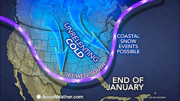
The weather pattern favoring relentless cold in the Eastern states and prolonged warmth in the West will continue through the end of January.

On multiple dates this month, temperatures have been warmer in Alaska than they have been in Texas, Louisiana and much of the Atlantic coast, including Florida.

Nome, Alaska, which lies at 64.5 degrees north latitude has experienced at least seven days so far this month where temperatures have climbed above freezing. The normal high for Nome is 13 F.

The City of Kotzebue, Alaska, which is nestled just above the Arctic Circle, climbed above the freezing mark on Jan. 23. The morning low in the city was only 27 F. Normal high and low temperatures for Kotzebue are respectively 3 and minus 10 F.


Comparatively, morning low temperatures on Jan. 23 were 27 F at Cross City, Fla., 8 F at Elizabeth City, N.C., and minus 2 F at Washington Dulles Airport, D.C.

During Friday morning, Jan. 24, temperatures pushed into the 40s in Anchorage and Fairbanks with rain in the vicinity. At the same time, temperatures in much of Texas and Louisiana were significantly lower with areas of ice and snow. Brownsville, Texas, and New Orleans dipped to 34 F, while Houston hovered near 30 F and Dallas bottomed out at 19 F.

RELATED:
Will It Snow on Feb. 2 in East Rutherford, N.J.?
Temperature Forecast Maps
Winter Weather Center


The cause of the topsy-turvy weather pattern has been produced by a high amplitude jet stream pattern. The jet stream is a fast-moving river of air high in the atmosphere that guides weather systems along and often marks the boundary between cold air to its north and warm air to its south.

The jet stream often becomes distorted from its average January position around 40 degrees north latitude. However, this pattern, in recent weeks, has become quite extreme. It has allowed warmth to push well to the north along the Pacific coast of North America and at the same time has sent frigid air well to the south over the middle of the continent to portions of the Atlantic coast.


Indications from AccuWeather.com Long Range Weather Expert Paul Pastelok are that the high amplitude jet stream will hold through the end of January, but during February the jet will shift a bit and may break into two parts.

"The pattern shift should allow Alaska to trend colder, less severe cold along the Atlantic coast and may allow some moisture to get onshore along the Pacific coast," Pastelok said.

The core of the cold air is projected to settle over the Central states and will be mostly contained between the Rockies and Appalachians.

However, this pattern will allow some cooler air to reach into the West and colder air to plunge into Texas.

"While we do expect some rain and mountain snow to reach parts of California and the West, but it may not be widespread and is not likely to be enough to have long-term impact on the drought," Pastelok said.

The upcoming pattern in February will also allow some storms loaded with moisture to track northeastward from the Gulf of Mexico to along the Atlantic Seaboard. With this pattern the chance of a heavy snowstorm would increase over much of the eastern third of the nation.

RELATED ON SKYE: SKYESCAPES: 15 Stunning Photos of Alaska


Permalink | Email this | Linking Blogs | Comments

Northeast Snow Next Week Includes Possible Coastal Storm

$
0
0
Saturday, Jan. 25, 2014


A storm that has a chance of bringing accumulating snow to a part of the Northeast will occur late Sunday into Monday. Another potential storm for the middle of next week is also being monitored.

The train of Alberta Clipper storms that began a couple of weeks ago will continue into early next week. Prior to dipping into the United States, the storms pass over the western and prairie provinces of Canada, where they get their name. Most of these storms are moisture-starved.

The pattern will have yielded close to a dozen clipper storms by this weekend. These storms have been of various strength and have taken a variety of paths.

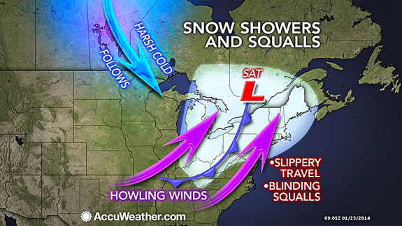
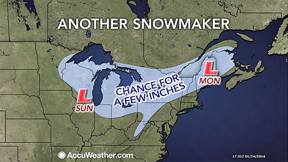
After a large, strong clipper storm blasts the Great Lakes and a large part of the Northeast with wind, snow and whiteouts into Saturday night, yet another clipper storm is due to sweep the area.

This clipper is scheduled to take a track across the Great Lakes Sunday and Sunday night, then the St. Lawrence Valley and northern New England on Monday. A few inches of snow will fall along the clipper's path.


Any snow that flies along the I-95 corridor from Boston to New York City to Washington, D.C., will be in the form of flurries.

The harsh cold in the wake of this clipper could rival prior arctic blast's as the coldest so far this winter.

RELATED:
Will It Snow on Feb. 2 in East Rutherford, N.J.?
Temperature Forecast Maps
Winter Weather Center


Yet another storm may affect part of the East Coast prior to the big game at East Rutherford, N.J.

According to AccuWeather.com Senior Meteorologist Bernie Rayno, "We have to watch for a storm trying to make a run up along the Atlantic Seaboard during the middle of next week."

Rayno is concerned that upper-level steering winds will change next week. While the change in jet stream winds would end the long train of Alberta Clipper storms, it could mark the beginning of a pattern favoring a different breed of storms, which move up from the South.


There would still be plenty of cold air in place for snow if such a storm were to hug the coast, rather than head quickly out to sea. Storms that typically move up from the South pack a great deal of moisture from both the Gulf of Mexico and the Atlantic Ocean.

Enough cold will also be present farther south for this possible storm to bring snow to the eastern Carolinas.

However, that cold could be so expansive that the storm waits to develop until well off the East Coast or its track is kept well away from the Northeast coast.

In the wake of a midweek storm threat, another clipper system may return snow showers and flurries to the Northeast on Thursday.

Details on the track and intensity of the storms and the extent of disruptions to travel and other daily activities next week will be made available as soon as possible on AccuWeather.com.

RELATED ON SKYE: 15 Photos of Monster Blizzards


Permalink | Email this | Linking Blogs | Comments

Look: Stargazer Snaps Breathtaking New Photo of Andromeda Galaxy

$
0
0
Saturday, Jan. 25, 2014


The Andromeda Galaxy, also known as Messier 31 (M31), is located 2.5 million light years from our own Milky Way. The image was shot on Dec. 6 and 15, 2013 from Las Cruces, N.M. (Jeff Johnson)

The Andromeda Galaxy takes center stage in this spectacular image captured by an amateur astronomer during a holiday stargazing session.

Astrophotographer Jeff Johnson took advantage of some clear night skies and holiday leave to capture this remarkable view of the Andromeda Galaxy from Las Cruces, N.M.

"In December -- after 6 months of poor weather here in Las Cruces [March to September] -- I was able to get out during a week of leave I had from work," Johnson wrote SPACE.com in an email. [See more amazing Andromeda Galaxy].

Johnson created the image from Andromeda observations recorded on Dec. 6 and 15. He used a Takahashi FS-60C @ f/6.2 telescope, Takahashi EM200 Temma II mount, QSI 540wsg@ -15C camera, with Astrodon Ha (3nm), Astrodon Tru-Balance I-Series LRGB Gen 2 filters and SX Lodestar guider. A version of the image that switches between Ha and non-Ha can be found on Johnson's website here.

The Andromeda Galaxy, also known as Messier 31 (M31),is located 2.5 million light-years from our own Milky Way. A light-year is the distance light travels in one year, about 6 trillion miles (10 trillion kilometers). Our closest neighbor, M31, contains hundreds of billions of stars and is visible with the naked eye. Together, the Andromeda and Milky Way galaxies dominate the Local Group of galaxies.

To see more amazing night sky photos submitted by SPACE.com readers, visit our astrophotography archive.

Editor's note: If you have an amazing night sky photo or video that you'd like to share for a possible story or image gallery, please contact managing editor Tariq Malik at spacephotos@space.com.

Follow SPACE.com on Twitter @Spacedotcom. We're also on Facebook & Google+. Original story on SPACE.com.

RELATED ON SKYE: Mind-Blowing New Photos from Space


Permalink | Email this | Linking Blogs | Comments

Next Polar Plunge Could Be Winter's Coldest

$
0
0
Saturday, Jan. 25, 2014

This recent image of Central Park in Manhattan shows its lakes partially frozen. This coming arctic blast will mean more ice for the park. (Cem Ozdel/Anadolu Agency/Getty Images)

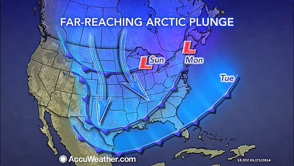
The next blast of brutal cold will grip most of the eastern two-thirds of the United States in the upcoming days and could yield the lowest temperatures so far this winter in many communities.

While harsh cold is returning to the Midwest and Northeast this weekend, it will pale in comparison to what will follow for Monday through Wednesday.

The impending polar plunge will rival the frigid days from earlier this January for the coldest daytime highs and nighttime lows so far this winter. That is especially true away from the Gulf Coast.

The arctic air will first plunge into the Upper Midwest, northern Plains and northern Rockies on Sunday, then continue pressing to the south and east through Tuesday.

The magnitude of this cold blast will be enough to produce a far-reaching threat of frostbite, hypothermia, frozen pipes and water main breaks.

Care should also be taken to ensure that livestock and other animals housed outdoors have adequate shelter.

Especially across the Midwest and Northeast, officials may decide to cancel or delay school due to the extreme cold. Some vehicles may struggle or fail to start for motorists.

RELATED:
Forecast Temperature Maps
Alaska to Florida: Topsy-Turvy Weather to Persist
Cold- and Snow-Related Watches, Warnings and Advisories

While highs will be held to the 30s southward to the I-20 corridor, the Midwest and Northeast are bracing for the harshest conditions.

Minneapolis, Chicago and other communities in the Upper Midwest will endure two consecutive days of subzero highs Monday through Tuesday. Overnight lows will drop to 20 below zero or lower from North Dakota to the western suburbs of Chicago.

Grand Forks, N.D., will bottom out at around 30 below zero.

Across most of the Northeast, highs will be held to the single digits and teens Tuesday and Wednesday.

Biting winds will usher in the frigid air, creating dramatically colder AccuWeather.com RealFeel(R) temperatures. Where snow is covering the ground, the winds will worsen the situation for motorists by blowing and drifting the snow around.

RealFeel(R) temperatures will be extremely dangerous across eastern North Dakota, Minnesota, Wisconsin and Upper Michigan Sunday night, ranging from 50 below zero to 60 below zero.

Frostbite can develop in a matter of minutes on exposed skin during such intense cold.

Along the leading edge of the invading cold will be an Alberta Clipper, set to spread a few inches of snow from the northern Plains to the Great Lakes and northern New England through Monday.

While Detroit already set a January snow record, the clipper may cause other Midwestern cities to follow suit. Once the cold takes up residence, the lake-effect snow machine will be cranked up across the Great Lakes.

Snow will also drop along the Front Range of the Rockies, including Denver, as the cold presses southward.

AccuWeather.com meteorologists are also monitoring the possibility of the cold setting the stage for snow to develop not only along the Northeast's coast at midweek, but also across the South.

RELATED ON SKYE: Epic Storm Photos from the Twittersphere

More details on this snow potential will be given in the upcoming days.

An expert analysis on the winter weather is given in the above AccuWeather.com video.


Read | Permalink | Email this | Linking Blogs | Comments

Viewing all 4069 articles
Browse latest View live


Latest Images