Quantcast
Channel: SKYE on AOL
Viewing all 4069 articles
Browse latest View live

Wind-Driven Snowstorm to Hammer DC, Philly, NYC and Boston

$
0
0

Updated Tuesday, Feb. 11, 2014, 8:20 p.m. ET
Winter Weather Kansas
(AP Photo)

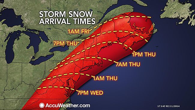
A storm bringing heavy ice and snow to the interior South will reach the Northeast Wednesday night and Thursday with heavy snow, gusty winds and disruptions to travel and daily activities.

The same storm set on disrupting flights at the major hubs of Atlanta, Dallas and Charlotte, N.C., in the South will take a tour of the Northeast before Valentine's Day. Airports from Washington, D.C., to Baltimore, Philadelphia, New York City and Boston will experience trouble with this storm.

Ice Storm

Flight delays and cancellations are possible throughout much of the nation well away from and ahead of the storm, due to aircraft and crews being displaced.

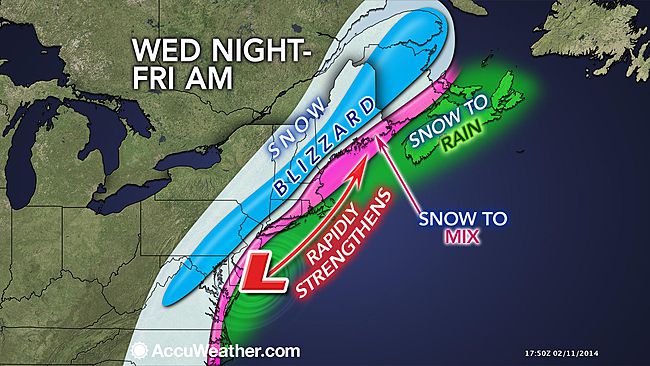
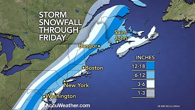
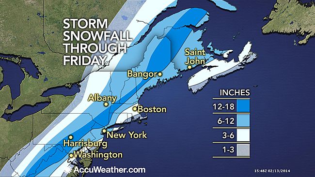
A swath of heavy snow is projected by AccuWeather.com to reach from portions of western and central Virginia, the West Virginia mountains and northern Maryland to southeastern and central Pennsylvania, northern New Jersey, southeastern New York and central New England.

This includes the I-81 corridor in Virginia, Maryland and part of Pennsylvania, as well as I-77 inNorth Carolina and Virginia and I-87 in New York.
Snowfall Through Friday

The storm will start as accumulating snow throughout the I-95 corridor and most coastal areas in the Northeast.

According to Chief Meteorologist Elliot Abrams, "While some rain can mix in along some of the I-95 cities, this will be a major storm throughout the corridor with enough snow to make for slippery roads and difficult travel."

RELATED:
AccuWeather.com Winter Weather Center
South Interactive Radar
Is the Northeast Running Out of Road Salt?

Even though the storm will move much faster through the Northeast, when compared to the South, it has the potential to bring a foot of snow in a swath north and west of the track of the center of the system. This is most likely in the northern and western suburbs of the I-95 cities in the mid-Atlantic and New England.

Snow Arrival Times

The system will track in such a way that part of the I-95 corridor will experience a change from snow to rain or to a mix of rain and snow. Such a scenario would result in added weight to the snow. The weight and increasing winds near the coast could bring down trees and power lines.

Inland from the coast, where the precipitation falls as all snow, the storm will garner enough wind to cause blowing and drifting snow at the height of and in the immediate wake of the storm.

According to Senior Meteorologist Henry Margusity, "In some areas from parts of Virginia, northeastward to New England, it may seem like a blizzard at times."

The storm is not likely to spare coastal areas, I-95 cities and their northern and western suburbs from heavy precipitation.

Folks from the Atlantic coast up to the Appalachians of the mid-Atlantic and New England should prepare for a classic nor'easter.

As the storm strengthens Thursday into Thursday night, enough onshore wind may be generated to cause minor flooding at times of high tide from New Jersey to Maine. The highest astronomical tides typically occur a day or so before the full moon, which happens to be on Friday, Valentine's Day. Water levels are likely to run 1 to 2 feet above published levels.

Storm

Prior to the arrival of the southern storm, most of the Northeast will be free of accumulating snow and will remain quite cold through the day Wednesday.

As of Tuesday midday, PECO was reporting that approximately 2,100 utility customers were still without power in the wake of the ice storm that hit southeastern Pennsylvania on Feb. 5, 2013.

There is the possibility of the power being knocked out in some of the same communities that were hit a week earlier.

For folks looking for a break in the cold, wintry pattern, a change to milder, less stormy weather is possible beginning around Feb. 17 or 18.

However, cold weather and storms may once again fight back toward the end of the month.

RELATED ON SKYE: 50 Must-See Weather Photos from 2013
Lightning Hits the Grand Canyon


Read | Permalink | Email this | Linking Blogs | Comments


Ice Storm Unfolds, Forces States of Emergency in South

$
0
0

Updated Tuesday, Feb. 11, 2014, 11:33 a.m. ET
Winter Weather Alabama
A truck slowly travels on a snow covered Alabama highway 176, Tuesday, Feb. 11, 2014 in Dog Town, Ala. (AP Photo/Hal Yeager)

With a major winter storm unfolding over the South, snow and ice will severely impact travelers and residents from Texas to the Carolinas through midweek.

Snow, sleet, rain and freezing rain began across the region on Monday night and is forecast to continue through much of Tuesday. During this day, the wintry precipitation will focus on an area stretching from southern North Carolina and upstate South Carolina, across northern Alabama, central Mississippi and into central Texas.

Road conditions are expected to deteriorate throughout Tuesday as flight delays and cancellations mount, but the worst of the storm looks to hold off until Wednesday and will focus from the southern Appalachians to just inland of the Atlantic coast in the Carolinas and Virginia.

Nearly 600 flights have been cancelled at Atlanta International Airport alone as of Tuesday midday.

Just a few of the many cities that will feel the impacts of this storm on Tuesday include Dallas, Shreveport, La.; Tupelo, Miss.; Birmingham and Huntsville, Ala.; Atlanta; Columbia, S.C.; and Fayetteville, N.C.

In many cases, roads may be too dangerous for travel. There is the potential to become stranded. If you drive, there is the risk of not only putting yourself at risk but also your would-be rescuers.

For folks that absolutely must travel, allow extra time in anticipation for delays as the snow and ice can rapidly accumulate on roadways, especially on bridges and overpasses.

While sleet is hazardous and difficult to remove, freezing rain brings the greatest risk for power outages and travel. This storm will bring both to many communities. However, the communities that receive between 0.50 and 1.00 inch of freezing rain could face severe problems.

On Monday afternoon, Georgia Gov. Nathan Deal announced a State of Emergency for 45 counties in the state ahead of the winter storm. Also on Monday, Alabama Gov. Robert Bentley issued a state of emergency for the entire state.

The worst of the storm appears as though it will hold off until Wednesday when the potential for a heavy ice buildup is most likely along the I-85 corridor.


According to senior meteorologist Mark Mancuso, "There is the potential for a historic ice storm from northern Georgia to central and upstate South Carolina to central North Carolina Tuesday night and Wednesday."

The area from Atlanta to Columbia, S.C., and Charlotte, N.C., may be ground zero for the ice storm. Some communities may experience great devastation from freezing rain.

A heavy buildup of freezing rain on trees and power lines can lead to scores of fallen trees, widespread power outages and bring travel to a halt.

"A number of communities over the interior South may have more significant, much longer-lasting sleet, freezing rain and snow when compared to the storm from late January," AccuWeather.com Southern weather expert meteorologist Dan Kottlowski said.

RELATED:
AccuWeather.com Winter Weather Center
South Interactive Radar
Major Winter Storm to Target Northeast Late Week


It may take many days for power to be completely restored across this area due to heavy icing over such a large area.

Heavy snow will fall on the northern Georgia, North Carolina and Virginia mountains with some locations forecast to receive a foot of snow or more. A half a foot to a foot of snow may fall Winston-Salem and Greensboro, N.C., and Roanoke, Va.

Although locations along the I-10 corridor will escape the danger the ice brings, heavy rain associated with the storm can lead to localized flooding, especially in low-lying and poor drainage areas.

Parts of central Florida may even have a few strong to severe thunderstorms.

This storm will continue to track up the East coast heading into Thursday, delivering over a foot of snow to portions of the Northeast.

RELATED ON SKYE: 30 Ice Sculptures That Will Take Your Breath Away


Read | Permalink | Email this | Linking Blogs | Comments

Hundreds of Flights Canceled at Southern Airports

$
0
0
Tuesday, Feb. 11, 2014
Deep Freeze Missouri
(AP Photo)

ATLANTA (AP) - As a winter storm with potential to coat the South with ice and snow moves in, nearly 900 flights have been canceled at three of the region's major airports.

Tracking service FlightAware shows that before dawn Tuesday, 894 flights for the day had been canceled into and out of the main airports in Atlanta, Dallas and Charlotte, N.C.

Hartsfield-Jackson Atlanta International Airport, the main hub for Delta Air, led the nation in Tuesday flight cancellations with 368.

Delta is allowing customers expecting to travel through several Southeastern cities from Tuesday to Thursday to make free one-time changes to their itineraries. The waiver applies to travelers passing through Atlanta; the Carolinas; Huntsville, Ala.; and Norfolk, Va.

RELATED ON SKYE: 30 Ice Sculptures That Will Take Your Breath Away


Permalink | Email this | Linking Blogs | Comments

Sochi Chief: No Need to Use Stored Snow -- Yet

$
0
0
Tuesday, Feb. 11, 2014
Sochi Olympics Alpine Skiing
The lower slopes appear devoid of snow as brown, dirty snow is piled up on the road to the finish area of the alpine ski venue at the Sochi 2014 Winter Olympics, Tuesday, Feb. 11, 2014, in Krasnaya Polyana, Russia. (AP Photo/Christophe Ena)

SOCHI, Russia (AP) - Sochi Olympic organizers see no need to bring in stored snow to cope with the warm temperatures in the mountains - but are ready to do so if necessary.

Dmitry Chernyshenko, head of the local organizing committee, said Tuesday that contingency plans are in place for covering slopes with snow preserved in reservoirs from previous winters.

Organizers have stored about 5,000 cubic feet of snow near the mountain venues above Sochi.

"In case we will need some snow, we can use it from our reservoirs," Chernyshenko said in an interview with the Associated Press. "We don't need it now. We didn't start our backup plan yet."

Temperatures in Sochi on the Black Sea coast have been rising, raising concerns about snow conditions. On Tuesday, temperatures reached 52 F along the coast and 41 F in the Alpine cluster in Krasnaya Polyana.

"It's not a big surprise for us," Chernyshenko said. "We're a sub-tropical city. We tested our mountain venues for the couple of previous winter seasons. We faced some abnormal warm weather."

Conditions at the half-pipe venue have been under particular scrutiny, with riders complaining about sand and mush at the bottom. Organizers said they would use chemicals to keep the ice frozen at higher temperatures.

"The weather is very unpredictable," Chernyshenko said. "Our forecast says the temperature will go down in a couple of days. We hope that no extra measures are needed."

Sochi also boasts Europe's largest snow-making system, which can even make snow at temperatures up to 15 C (60 F). Chernyshenko said snow-making was being used at the ski jump of the Nordic combined venue.

Meanwhile, Chernyshenko said he was relieved the focus has turned to the athletes and the competitions after the buildup to the games was dominated by security and political concerns.

"When the battle goes to the venues and the competition, everybody starts to discuss the achievements of the athletes rather than some political issues," he said.

Organizers have also come under fire for unfinished hotel rooms, empty seats and lack of atmosphere.

"Everything was predictable," Chernyshenko said. "Sometimes we were under the criticism, we were fixing some issues. I know the majority of the coverage is (now) positive and we really appreciate it."

Chernyshenko said empty seats at some venues were the result of fans going in and out during long sessions, not from lack of turnout.

"We're absolutely happy with attendance, now that we're very close to sold out," he said. "We can create atmosphere in the games which is electric now, with a crowd of people gathering at all venues."

He said 77,000 people turned out Monday night to watch the Russian figure skating team receive their gold medals.

Crowds and enthusiasm will grow now that the NHL players have arrived for the men's hockey tournament, he said. Hockey is hugely popular in Russia and a gold medal would be the ultimate prize for the country.

The overall success of Russian athletes in the medals race is crucial to the atmosphere of the games, Chernyshenko said.

"Without athletes on the podium, the games will not be that successful," he said. "We really enjoy the atmosphere and support of Russian fans."

RELATED ON SKYE: The 10 Snowiest Places on Earth


Permalink | Email this | Linking Blogs | Comments

Atlanta Area Braces for Ice Storm; 4 Killed in Texas

$
0
0
Updated Tuesday, Feb. 11, 2014, 5:25 p.m. ET
Winter Weather Alabama
A truck slowly travels on a snow-covered Alabama Highway 176, Feb. 11, 2014, in Dog Town, Ala. (AP Photo/Hal Yeager)

ATLANTA (AP) - The city dodged the first punch of a dangerous winter storm Tuesday, but forecasters warned of a potentially "catastrophic" second blow in a thick layer of ice that threatened to bring hundreds of thousands of power outages and leave people in their cold, dark homes for days.

The streets and highways in metro Atlanta were largely deserted as people in the South's business hub heeded advice from officials to hunker down at home, especially after the snow jam two weeks ago saw thousands of people stranded on icy, gridlocked roads for hours when 2 inches of snow fell.

Related on SKYE: Wind-Driven Snowstorm to Hammer DC, Philly, NYC and Boston

"Last time I was totally unprepared, I was completely blindsided," said Lisa Nadir of Acworth, who sat in traffic for 13 hours and then spent the night in her car when the storm hit Jan. 28. "I'm going to be prepared from now on for the rest of my life."

Nadir was telecommuting from home Tuesday and she had kitty litter in her trunk in case she needed to put it dow n on icy roads for extra traction.

The forecast drew comparisons to an ice storm in the Atlanta area in 2000 that left more than 500,000 homes and businesses without power and an epic storm in 1973 that caused an estimated 200,000 outages for several days. In 2000, damage estimates topped $35 million.

Eli Jacks, a meteorologist with National Weather Service, said forecasters use words like "catastrophic" sparingly.

"Sometimes we want to tell them, 'Hey, listen, this warning is different. This is really extremely dangerous and it doesn't happen very often,'" Jacks said.

This kind of language was first used in May 1999 for a tornado in Moore, Okla. Forecasters called it a "tornado emergency" to make sure the public knew it was not a typical tornado.

"I think three-quarters of an inch of ice anywhere would be catastrophic," Jacks said.

But the Atlanta area and other parts of the South are particularly vulnerable because there are so many tree s and limbs hanging over power lines. When the ice builds up on them, limbs snap and fall, knocking out power.

"There is no doubt that this is one of Mother Nature's worst kinds of storms that can be inflicted on the South, and that is ice. It is our biggest enemy," Georgia Gov. Nathan Deal said.

While only light rain fell in Atlanta on Tuesday, cities 40 miles northwest saw 2 to 3 inches of snow. The rain was expected to turn into sleet and freezing rain overnight.

More than 200 utility vehicles from Florida, North Carolina and other Southern states gathered in a parking lot near one of the grandstands at Atlanta Motor Speedway. The state had more than 22,000 tons of salt, 70,000 gallons of brine 45,000 tons of gravel and brought in 180 tons of additional salt and sand. The goal was to make sure at least two interstate lanes were available in each direction. Then material would be used on the most heavily used roads off the highways. Officials were also considering rerouting traffic in extreme circumstances.

"It's certainly going to be a challenge for us. Ice is definitely different than snow," said state Transportation Commissioner Keith Golden. "It is very difficult for us to plow ice."

Hundreds of Georgia National Guard troops were on standby in case evacuations were needed at hospitals or nursing homes, and more than 70 shelters were set to open. President Barack Obama declared a state of emergency in Georgia, ordering federal agencies to help the state and local response during the storm. Deal said a priority for that request was generators.

Metro Atlanta, the economic engine of the South with the headquarters of Fortune 500 companies including Home Depot, UPS, Delta Air Lines and Coca-Cola, resembled a ghost town. Schools were closed and grocery store shelves were bare of milk and bread.

State and local officials, chastened by tough criticism for their slow response to the Jan. 28 storm, were eager to prove they could handle winter storms.

On Monday, before a drop of freezing rain or snow fell, Deal declared a state of emergency for nearly a third of the state and state employees were told they could stay home. He expanded the declaration Tuesday to more than half the state's counties.

Dustin Wilkes, 36, of Atlanta, was one of the few who headed to the office Tuesday. His parking lot was mostly deserted.

"I think they probably overreacted," Wilkes said. "It's to be expected."

Atlanta has a painful past of being ill-equipped to deal with snowy weather. Despite officials' promises after a crippling ice storm in 2011, the Jan. 28 storm proved they still had many kinks to work out.

Around the Deep South, slick roads were causing problems. In North Texas, at least four people died in traffic accidents on icy roads, including a Dallas firefighter who was knocked from an Interstate 20 ramp and fell 50 feet, according to a police report.

In northeastern Alabama, two National Guard wreckers were dispatched to help clear jackknifed 18-wheelers on Interstate 65. Gov. Robert Bentley said one lesson learned from the storm two weeks ago was to get those wreckers organized earlier.

Michelle Owen, of Mount Pleasant, Tenn., was driving north on Interstate 65 when she hit an icy patch on a bridge. Her sport-utility vehicle and a trailer it was pulling fishtailed, sending her 18-year-old son Tyler through the rear window and on to the car that was atop the trailer.

"He wound up on top of the Mustang we were hauling," Owen said. He suffered only minor injuries.

Parts of northeast Mississippi could see up to 4 inches of snow. South Carolina, which hasn't seen a major ice storm in nearly a decade, could get a quarter to three-quarters of an inch of ice and as much as 8 inches of snow in some areas.

Delta canceled nearly 2,200 flights on Tuesday and Wednesday, most of them in Atlanta.

RELATED ON SKYE: 50 Must-See Weather Photos from 2013
Lightning Hits the Grand Canyon


Permalink | Email this | Linking Blogs | Comments

Photos: Olympic Athletes Defy Russian Airspace

Photos: Winter Storm Bears Down on Southern US

Major Ice Storm Causes Havoc Across US South

$
0
0
Updated Wednesday, Feb. 12, 2014, 8:53 p.m.
Winter Weather North Carolina
Two unidentified women back home through the snow after walking to a grocery store, only to find it closed, Wednesday, Feb. 12, 2014, in Charlotte, N.C. (AP Photo/Chuck Burton)

ATLANTA (AP) - The second wintry storm in two weeks to hit the normally warm U.S. South encrusted the region in ice Wednesday, knocking out electricity to hundreds of thousands of homes and businesses. It then pushed toward the heavily populated Northeast.

At least 11 deaths across the region were blamed on the treacherous weather, including three people who were killed when an ambulance careened off an icy Texas road and caught fire.

Nearly 3,300 airline flights nationwide were cancelled.

In an warning issued early Wednesday, National Weather Service called the storm "catastrophic ... crippling ... paralyzing ... choose your adjective."

PHOTOS ON SKYE: Winter Storm Bears Down on Southern US
Forecasters warned of more than an inch (2.5 centimeters) of ice possible in places. Snow was forecast overnight, with up to 3 inches (7.6 centimeters) possible in Atlanta and much higher amounts in the Carolinas.

President Barack Obama declared a disaster in South Carolina and for parts of Georg ia, opening the way for federal aid. In Myrtle Beach, South Carolina, palm trees were covered with a thick crust of ice.

The storm didn't cause the widespread highway problems in Atlanta that the last storm did, largely because people had learned their lesson. Streets and highways were largely deserted.

The storm then moved northward, threatening to bring more than a foot (30 centimeters) of snow Thursday to the mid-Atlantic and Northeast.

Washington D.C. could get up to 8 inches (20 centimeters) of snow. New York City could see 6 inches (15 centimeters).

Ice combined with wind gusts up to 30 mph (48 kph) snapped tree limbs and power lines. More than 200,000 homes and businesses lost electricity in Georgia, 130,000 in South Carolina and nearly 30,000 in Louisiana. Some people could be in the dark for days.

Atlanta was caught unprepared by the last storm on Jan. 28, when thousands of children were stranded all night in schools by less than 3 inches (less than 8 centimeters) of snow and countless drivers abandoned their cars.

PHOTOS ON SKYE: Winter Storm Bears Down on Southern US
South Traffic Ice


Permalink | Email this | Linking Blogs | Comments


Storm With 100 MPH Gusts Hits Soggy Britain

$
0
0
Updated Wednesday, Feb. 12, 2014, 12:50 p.m.
Britain Floods
A local resident cycles through the flooded part of the town of Staines-upon-Thames, England, Wednesday, Feb. 12, 2014. (AP Photo/Lefteris Pitarakis)

LONDON (AP) - Britain's weather service says it sees the tentacles of climate change in a spate of storms and floods battering the country, but has stopped short of saying warming directly caused the extreme storms.

The latest round of bad weather hit Britain's west coast Wednesday with winds gusting at more than 100 miles (160 kilometers) an hour.

The Met office said in a paper published this week that "there is no definitive answer" on the role played by climate change in the recent weather and floods.

But it said there is "an increasing body of evidence that extreme daily rainfall rates are becoming more intense," probably due to a warming world.

Met office chief scientist Julia Slingo told the BBC that "all the evidence suggests there is a link to climate change."

The Met office study discusses evidence of increasingly extreme weather events and changes in the jet stream, but it does not say global warming caused the flooding. To do that, scientists take months, sometimes years, to conduct detailed computer simulations - and the report said such research was needed in this case.

England had its wettest January since records were first kept almost 250 years ago, and the country has been lashed by wind and rain since December.

Resulting floods have drenched the southwestern coast of England, the low-lying Somerset Levels and the Thames Valley, west of London, where hundreds of properties have been swamped as the river burst its banks this week.

The Met office issued a highest-level red warning of "exceptionally strong winds" Wednesday for west Wales and northwest England.

It said a gust of 106 mph (170 kph) was recorded at Aberdaron in northwestern Wales.

The Met Office said gusts could cause widespread structural damage and loss of power. Railway operator Network Rail said the main west coast train line would close for about two hours Wednesday evening because of the wind.

RELATED ON SKYE: Huge Waves Batter U.K.
UK Big Waves


Permalink | Email this | Linking Blogs | Comments

Nor'easter to Hammer DC, Philly, NYC and Boston

$
0
0
Updated Wednesday, Feb. 12, 2014, 5:48 p.m. ET
Winter Weather Massachusetts
Peggy Udden, of Norwood, Mass., shovels her driveway in Norwood, Wednesday, Feb. 5, 2014. (AP Photo/Steven Senne)

A storm bringing heavy ice and snow to the interior South at midweek will reach the Northeast Wednesday night and Thursday with heavy snow, wintry mix, gusty winds and disruptions to travel and daily activities.

The same storm disrupting flights at the major hubs of Atlanta, Dallas and Charlotte, N.C., in the South will take a tour of the Northeast before Valentine's Day. Airports from Washington, D.C., to Baltimore, Philadelphia, New York City and Boston will experience trouble with this storm.


Flight delays and cancellations occurred well away from the storm, due to aircraft and crews being displaced at southern hubs on Wednesday.

A swath of heavy snow is projected by AccuWeather.com to reach from portions of western North Carolina, western and northern Virginia, the West Virginia mountains and northern Maryland to southeastern and central Pennsylvania, northern New Jersey, southeastern New York and central and northern New England.

This includes the I-81 corridor in Virginia, Maryland and part of Pennsylvania, as well as I-77 inNorth Carolina and Virginia and I-87 in New York.


The storm will start as accumulating snow throughout the I-95 corridor and most coastal areas in the Northeast.

According to Chief Meteorologist Elliot Abrams, "While a change to rain can occur along some of the I-95 cities and most areas along the coast, this will be a major storm throughout the corridor with enough snow to make for slippery roads and difficult travel."

Even though the storm will move much faster through the Northeast, when compared to the South, it has the potential to bring a foot of snow in a swath north and west of the track of the center of the system. This is most likely from the northern and western suburbs of the I-95 cities in the mid-Atlantic and New England to the Appalachians.


Where snow mixes with or changes to rain, the added weight to the snow will not only make it difficult to shovel and plow. Increasing winds in part of the I-95 zone could bring down trees and power lines.

Well inland from the coast, where the precipitation falls as all snow, the storm will garner enough wind to cause blowing and drifting snow at the height of and in the immediate wake of the storm.

RELATED:
AccuWeather.com Winter Weather Center
South Interactive Radar
Is the Northeast Running Out of Road Salt?


According to Senior Meteorologist Henry Margusity, "In some areas from parts of Virginia, northeastward to New England, it may seem like a blizzard at times."

Folks from the Atlantic coast up to the Appalachians of the mid-Atlantic and New England should prepare for a classic nor'easter.

As the storm strengthens Thursday into Thursday night, enough onshore wind may be generated to cause minor flooding at times of high tide from Delmarva to Maine.

The highest astronomical tides typically occur a day or so before the full moon, which happens to be on Friday, Valentine's Day. Water levels are likely to run about 2 feet above published levels from New Jersey on to the north.

There is the possibility of the power being knocked out in some of the same communities that were hit a week earlier.

For folks looking for a break in the cold, wintry pattern, a change to warmer weather is possible beginning around Feb. 17 or 18 and may continue through much of the balance of the month. The amount of flooding, if any, will depend on how quickly snow melts over the region and whether or not heavy rain accompanies the thaw.

Prior to the warmup next week, a more modest storm will swing from the Central states on Friday to the Northeast coast by Saturday.

PHOTOS ON SKYE: Winter Storm Bears Down on Southern US
Snow Ice South


Permalink | Email this | Linking Blogs | Comments

2 Killed, 2 Hurt by Avalanche in Eastern Oregon

$
0
0
Wednesday, Feb. 12, 2014
Wallowa Mountains, snow, horses
Wallowa Mountains. (Getty Images)

PORTLAND, Ore. (AP) - Two backcountry skiers were killed and two others were seriously injured when an avalanche in eastern Oregon's Wallowa Mountains hit a party of eight, officials said.

The deaths mean at least 12 people have died in avalanches nationally this season, including six since Sunday.

Low clouds and poor visibility grounded a rescue effort for the injured skiers late Tuesday night, Baker County Undersheriff Warren Thompson said. Two medics were with the man and woman.

Four unhurt skiers were being brought out by snowcat, a large tracked vehicle that can maneuver on snow, Thompson said.

The snowcat was unable to reach the injured skiers because of the incline of the slope they were on, the undersheriff said. The injured woman suffered two broken legs and a shoulder injury while the man had a broken thigh bone, Thompson said.

Two National Guard helicopters, one each from Oregon and Idaho, hoped to resume rescue efforts Wednesday, Thompson said. They spent the night at the Baker City Airport. Ground rescue crews also worked to get closer to the site.

Most of the skiers were from the Seattle area. Officials weren't releasing names until relatives could be notified.

The avalanche hit at about noon Tuesday as the eight skied in the remote and mountainous area near Cornucopia, Baker County Sheriff Mitch Southwick said in a statement.

Connelly Brown, the owner of Wallowa Alpine Huts, said the skiers were part of a backcountry skiing group organized by his Joseph-based company. The group included two guides and six skiers.

Brown said a guide contacted him by cellphone after the avalanche hit, reporting two possible fatalities and two skiers with broken legs. The skiers were on a guided five-day, four-night trip, he said.

The avalanche came down on the third day of the trip, Brown said. Later that night, as on previous nights, the group planned to sleep at the Schneider Cabin, a historic miners' log cabin on the south side of Cornucopia Peak.

Brown said the clients and the guides were all "fit, proficient downhill skiers." The guides were certified by the American Institute for Avalanche Research and Education and trained by the American Mountain Guide Association, he said.

"From the description, it sounded like they were traveling and the avalanche came from above and caught them by surprise," Brown said.

The avalanche occurred in the southern part of the Wallowa Mountains, near the Idaho border. The Wallowas are known as the "Alps of Oregon." With their rocky peaks and deep ravines, the mountains are popular with backcountry skiers, hikers and horseback riders.

A bulletin from the Wallowa Avalanche Center on Thursday warned that "new snow is not bonding well to the old surface." The bulletin mentioned a recent report from the southern Wallowas of a skier triggering a small avalanche in which no one was caught.

Elsewhere, Kevin Kuybus, 46, of Highlands Ranch, Colo., was found dead Tuesday after an avalanche outside a Colorado ski area. Another avalanche near Kebler Pass, Colo., killed a snowmobiler Monday.

The death toll includes two people who died in slides in Utah over the weekend. On Sunday, Ashleigh Cox, 21, of Colorado Springs died after being caught in an avalanche while she was snowshoeing Saturday in American Fork Canyon. About 90 miles away in Sanpete County, Clint Conover, 36, died after being buried in a slide Sunday while snowmobiling.

RELATED ON SKYE: 50 Incredible Photos of Forces of Nature
Volcano Eruption


Permalink | Email this | Linking Blogs | Comments

Look: Sochi's Dazzling Olympic Lights Seen From Space

$
0
0
The 2014 Winter Olympic Games in Sochi, Russia, certainly dazzle, even from hundreds of miles away. On Tuesday, Feb. 11, an astronaut aboard the International Space Station snapped this striking picture of the resort town and its glittering lights. The Johnson Space Center tweeted the image, writing, "Dramatic photo taken by the ISS crew showing #Sochi Olympic Park. Fisht Stadium and the flame are visible."

PHOTOS ON SKYE: Olympic Athletes Defy Russian Airspace


Permalink | Email this | Linking Blogs | Comments

Life's a Beach at the Winter Olympics

$
0
0
Wednesday, Feb. 12, 2014
Sochi Olympics
Oxsana Kharitonova lyes on the grass while posing for a photograph with friends on a sunny warm day at the 2014 Winter Olympics, Wednesday, Feb. 12, 2014, in Sochi, Russia. (AP Photo/David J. Phillip)

SOCHI, Russia (AP) - Forget the parkas and stocking hats. Sunscreen and shades are the must-have items at the Sochi "Winter" Games.

The temperature soared to 63F on Wednesday, prompting Olympic visitors to grab a nap on a bench outside a venue or hit the nearby beach for some impromptu sunbathing and even a dip in the Black Sea.

"I think it should always be like this," said Yuri Valyeyev, a resident of Bryansk, between Sochi and Moscow, who came here to work in construction during the Olympics. "We are glad that it is held in Russia. Being a Russian I am very glad because everywhere in Russia is cold and here is warm."

Organizers say they're getting exactly what they expected from Sochi's subtropical climate. Sure, it's making life difficult for the skiers and snowboarders slushing through their runs on the mountain. But for thousands of fans and workers in this resort town, the warmth has been a welcome getaway from harsh winters elsewhere.

And the heat just keeps on coming.

Forecasts call for highs of 63F on Thursday and Friday and 61F on Saturday before a gradual cool down the low 50s on Sunday. While the warm temperatures are making life difficult for the skiers and snowboarders on the mountain in Krasnaya Polyana, they have provided a welcome relief to Russians, Canadians, Americans and other visitors who have endured harsh winters back home.

Just a few hundred yards (meters) from Olympic Park, visitors shed their clothes and lounged on the rocky shores of the Black Sea. Fishermen cast their lines into the water and Valyeyev jumped right in.

"The water, you can bear it," Valyeyev said with a shrug of his shoulders. "And it's normal for a Russian man."

For Russian President Vladimir Putin and the Russian Olympic Committee, bringing the games to the subtropical climes of Sochi was as much an investment in the long-term prospects for this resort village by the sea as it was for any immediate payoff that the influx of visitors, and money, would bring. They saw it as an opportunity to establish Sochi as an attractive vacation destination for visitors from all over the world, and from the rest of Russia, in particular.

Seeing lush green grass blanket the mountain cluster of events rather than billowy snow may not be advantageous in the short run. But it could get others thinking about heading to Sochi when they need to break from another long, hard winter.

"Yes, the weather is absolutely gorgeous, which is, of course, challenging," Sochi 2014 spokeswoman Aleksandra Kosterina said. But, she added: "Nothing we are not prepared for."

In Moscow, it was 35F on Thursday and has been brutally cold for much of the season. It was 24F in New York on a day that another nasty storm was spreading across the Southeastern United States and threatening to cancel or postpone games. And Sochi was also considerably warmer than two cities it beat out for the 2014 Games - Pyeongchang, South Korea (28F), and Salzburg, Austria (40F).


Permalink | Email this | Linking Blogs | Comments

NASA Sun-Watching Spacecraft Celebrates 4th Birthday with Amazing Video

$
0
0

A NASA sun-studying probe celebrates four years in space this week, and the agency has released a stunning new video to mark the occasion.

The amazing new video of the sun, which NASA released Tuesday, is a greatest-hits set from the space agency's powerful Solar Dynamics Observatory (SDO), which is celebrating its fourth year in space. The video showcases some of SDO's most dramatic and beautiful images from the last 12 months.

The nearly four-minute movie includes footage of sunspots, solar flares -- powerful blasts of light in X-ray and other wavelengths -- and prominence eruptions, which send loops of solar material out into the sun's atmosphere.

NASA's Solar Dynamics Observatory blasted off from Florida's Cape Canaveral Air Force Station on Feb. 11, 2010, on a mission to study solar activity and help scientists understand how variations in that activity affect life here on Earth.

NASA Sun
This image is a composite of 25 separate images spanning the period of Feb. 11, 2013 to Feb. 11, 2014. (NASA's Goddard Space Flight Center/SDO/S. Wiessinger)

"Scientists study these images to better understand the complex electromagnetic system causing the constant movement on the sun, which can ultimately have an effect closer to Earth, too: Flares and another type of solar explosion called coronal mass ejections can sometimes disrupt technology in space," NASA officials wrote in a description of the video. nasa-sun-observatory-fourth-anniversary-video-sdo

SDO captures high-resolution views of the sun in 10 different wavelengths 24 hours a day, seven days a week. The probe records images of the solar atmosphere in unprecedented detail, researchers say.

The $850 million SDO mission was the first launched under NASA's Living With a Star program, which aims to help researchers better understand aspects of the sun-Earth system that affect our lives and society.

SDO was designed to last a minimum of five years, but mission scientists hope it can keep observing for a while beyond that, providing an in-depth look at much of the sun's 11-year activity cycle. The space observatory launched during a relatively quiet period for the sun. The current cycle, known as Solar Cycle 24, is the weakest in a century or so, despite being in its active phase, researchers say.

Follow Mike Wall on Twitter @michaeldwall and Google+. Follow us @Spacedotcom, Facebook or Google+. Originally published on Space.com.

Copyright 2014 SPACE.com, a TechMediaNetwork company. All rights reserved. This material may not be published, broadcast, rewritten or redistributed.

RELATED ON SKYE: The 50 Best Space Photos of 2013
NASA Sun


Permalink | Email this | Linking Blogs | Comments

More Snow to Smack DC, Philly, NYC and Boston

$
0
0
Updated Thursday, Feb. 13, 2014, 4 p.m. ET
A bicyclist rides through a snowstorm in the Chinatown neighborhood of New York, Thursday, Feb. 13, 2014. Snow and sleet are falling on the East Coast, from North Carolina to New England, a day after sleet, snow and ice bombarded the Southeast. (AP Photo/Mark Lennihan)
A bicyclist rides through a snowstorm in the Chinatown neighborhood of New York, Thursday, Feb. 13, 2014. (AP Photo/Mark Lennihan)

Even though snow tapered off or changed to rain in parts of the Northeast Thursday afternoon, more snow is coming from the nor'easter.

Some locations may even experience thunder and lightning with the last batch of snow from the storm.

A storm that brought heavy ice and snow to the interior South at midweek wasted no time clobbering the Northeast on Thursday with heavy snow, wintry mix, gusty winds and disruptions to travel and daily activities.

A push of warmer air from the ocean changed snow to rain along part of the I-95 corridor Thursday morning. A push of dry air from the south managed to shut down snow, ice and rain for a time Thursday afternoon. However, more snow is forecast to pivot across the I-95 mid-Atlantic Thursday night.

Storm

The snow will roll from southwest to northeast, bringing an accumulation of a couple of inches to some coastal areas, but perhaps as much as a fresh 6 inches of so to areas north and west of I-95.

The snow can cover up roads and sidewalks that had been cleared off Thursday afternoon.

Meanwhile, heavy snow will continue to push northward into eastern upstate New York and New England, where the bulk of the storm is yet to come Thursday night.

Thousands of flight delays and cancellations occurred well away from the storm, due to aircraft and crews being displaced at southern hubs on Wednesday. These delays and cancelations continued Thursday. More than 5,600 flights were canceled into or out of the United States Thursday with at least 1,100 other flights delayed.

The storm has delivered up to about 18 inches of snow on parts of the central Appalachians and interior mid-Atlantic thus far. Philadelphia now has at least a top-five winter in terms of snowfall.

With the snow that has already fallen and the additional snow coming Thursday night, travel will remain difficult and dangerous in many areas of the Northeast.

Storm

According to Senior Meteorologist Henry Margusity, "In some areas from parts of Virginia northeastward to New England, it may seem like a blizzard at times."

As the storm strengthens into Thursday night, enough onshore wind may be generated to cause minor flooding at times of high tide from the Delmarva Peninsula to Maine.

RELATED:
AccuWeather.com Winter Weather Center
Northeast Interactive Radar
Get the Latest Reports on the Winter Storm


The highest astronomical tides typically occur a day or so before the full moon, which happens to be on Friday, Valentine's Day. Water levels are likely to run about 2 feet above published levels from New Jersey on to the north.

There is the possibility of the power being knocked out in some of the same communities that were hit a week earlier.

Friday Saturday Storm

For folks looking for a break in the cold, wintry pattern, a change to warmer weather is possible beginning around Feb. 17 or 18 and may continue through much of the rest of the month. The amount of flooding, if any, will depend on how quickly snow melts over the region and whether or not heavy rain accompanies the thaw.

Prior to the warmup next week, another storm with snow will swing from the Central states on Friday to the mid-Atlantic and New England coast by Saturday.

That storm could strengthen rapidly near Cape Cod, Mass., and could bring near-blizzard conditions to part of southeastern New England and the Maritimes.

PHOTOS ON SKYE: Winter Storm Takes Aim at East Coast


Permalink | Email this | Linking Blogs | Comments


Ice Storm Causes More Havoc Across US South

$
0
0
Thursday, Feb. 13, 2014
Winter Storm Affects Large Swath Of Southern States
Northbound on Interstate 85 is at a standstill at rush-hour on February 12, 2014, in Durham, North Carolina. (Photo by Sara D. Davis/Getty Images)

ATLANTA (AP) - The second winter storm in two weeks to hit the U.S. South encrusted the region in ice, knocking out electricity to hundreds of thousands of homes and businesses before pushing toward the heavily populated Northeast.

The storm was threatening to dump up to 20 inches (51 centimeters) of snow Thursday to some areas in the mid-Atlantic and the Northeast.

At least 11 deaths across the region were blamed on the treacherous weatherWednesday, including three people who were killed when an ambulance careened off an icy Texas road and caught fire.

Nearly 3,300 airline flights nationwide were cancelled.

The National Weather Service called the storm "catastrophic ... crippling ... paralyzing ... choose your adjective."

New York City could see up to 12 inches (30 centimeters) of snow, the agency said, and Washington D.C. could get up to 8 inches (20 centimeters). Federal offices in Washington were closed Thursday.

President Barack Obama declared a disaster area in South Carolina and for parts of Georgia, opening the way for federal aid. In Myrtle Beach, South Carolina, palm trees were covered with a thick crust of ice.

Ice combined with wind gusts up to 30 mph (48 kph) snapped tree limbs and power lines Wednesday. More than 200,000 homes and businesses lost electricity in Georgia, 130,000 in South Carolina and nearly 30,000 in Louisiana. Some people could be in the dark for days.

The constant spate of storms is taking a financial toll. The state of Massachusetts has already burned through its $43 million snow-and ice-fighting budget - having spent about $75 million before Thursday's storm even hit.

In North Carolina, drivers got caught in monumental traffic jams and abandoned their cars Wednesday in a replay of what happened in Atlanta just two weeks ago.

While Atlanta's highways were clear, apparently because people learned their lesson and stayed home, thousands of cars were backed up on the slippery, snow-covered interstates around Raleigh, North Carolina, and short commutes turned into hours-long journeys.

PHOTOS ON SKYE: Winter Storm Bears Down on Southern US
South Traffic Ice


Permalink | Email this | Linking Blogs | Comments

Olympic Officials Not Worried About Warm Weather

$
0
0
Thursday, Feb. 13, 2014
Around The Games: Day 6 - 2014 Winter Olympic Games
People lay on the grass in the warm weather outside Bolshoy Ice Dome on day six of the Sochi 2014 Winter Olympics at the Olympic Park on February 13, 2014, in Sochi, Russia. (Photo by Bruce Bennett/Getty Images)

SOCHI, Russia (AP) - Olympic officials remain unconcerned about continuing warm temperatures at the Sochi Winter Games.

Forecasts called for highs in the mid-60s on Thursday. They weren't expected to cool down until Saturday at the earliest.

International Olympic Committee spokesman Mark Adams says it's "always a constant battle for winter sports" to maintain optimal conditions when the weather warms up. He says they "are relaxed, but will watch the situation" as the days progress.

The outdoor events, including slopestyle skiing and biathlon, remain on schedule.

Sochi 2014 spokeswoman Aleksandra Kosterina says they have not had to tap into the snow reserves they are storing on the mountain. She says "we are not worried, but at the same time we are ready for taking measures if there is a need."

PHOTOS ON SKYE: Olympic Athletes Defy Russian Airspace


Permalink | Email this | Linking Blogs | Comments

Stroke Risk Tied to Cold, Humidity, Weather Swings

$
0
0
Thursday, Feb. 13, 2014
FILE - In this Tuesday, Jan. 21, 2014 file photo, tourists walk through the snow-covered Empty Sky Memorial at Liberty State Park in Jersey City, N.J. Researchers who analyzed local climate trends and hospital records on millions of Americans say there may be a link between weather and the risk for stroke. Cold weather, high humidity and big daily temperature swings brought more stroke hospitalizations. The study by researchers from Yale, Harvard and Duke universities was discussed Wednesday, Feb. 12, 2014 at a stroke conference in San Diego. (AP Photo/Julio Cortez)
In this Tuesday, Jan. 21, 2014, file photo, tourists walk through the snow-covered Empty Sky Memorial at Liberty State Park in Jersey City, N.J. (AP Photo/Julio Cortez)

There may be a link between weather and the risk of suffering a stroke, say researchers who analyzed climate trends and hospital records on millions of Americans.

Cold weather, high humidity and big daily temperature swings seem to land more people in the hospital with strokes. As it got warmer, risk fell - 3 percent for every 5 degrees, the study found.

"Maybe some of these meteorological factors serve as a trigger," said Judith Lichtman, a Yale University stroke researcher who led the study. With global climate change and extreme weather like this week's freak storm in the South, "this could be increasingly important," she said.

Lichtman and colleagues from Harvard and Duke universities gave results of their study Wednesday at the American Heart Association's International Stroke Conference in San Diego. It is the largest and most detailed research on this issue.

Each year, about 800,000 Americans have a stroke. Most are due to clots that block a blood vessel to the brain, and high blood pressure is a major risk factor.

Some earlier studies found a seasonal trend to stroke rates, and there are biological reasons to think they are related, said one independent expert, Dr. Andrew Stemer, a neurologist at Georgetown University.

Blood vessels constrict in cold weather, which can raise blood pressure, he said. Extreme weather can trigger a stress reaction by the body, causing it to release substances "that not only increase the work of the heart" but make blood stickier and more likely to clot, Stemer said.

In cold weather "your body clamps down, there's cardiovascular stress," said Dr. Larry Goldstein, a Duke stroke specialist who worked on the study.

Conversely, "high humidity may cause dehydration," which also can raise the risk for clots and raise stress on the body, he said. "You know how you feel when you're out in hot, humid weather - you don't feel so hot."

Several of these same researchers published another study earlier this year that looked at stroke deaths from 1999 to 2006 among Medicare patients and found a pattern - higher rates in the winter, lower in summer and a small peak in July.

The new study looked at stroke hospitalizations, not just deaths, in a wider population of adults using a federal database covering all states except Idaho, North Dakota, Delaware and New Hampshire. Researchers also had daily climate data down to the county level from the National Climatic Data Center for 2010 and 2011.

Researchers tracked only strokes caused by clots, not the less common kind caused by a burst or bleeding blood vessel.

Lower temperatures, larger daily temperature changes and higher dew points (humidity) were tied to higher stroke hospitalization rates.

Each 5-degree increase in daily temperature fluctuation (the highest reading minus the lowest one) raised the chance of stroke hospitalization by 6 percent. Each 5-degree rise in the dew point (humidity) raised the risk by 2 percent.

The researchers did not establish a threshold when things were too hot - the point of the study was tracking the general trend, Lichtman said.

The results mean that during extreme weather, friends and relatives should "keep an eye on people that are at high risk, those who are older," she said.

During stressful weather conditions, "you want to watch your diet, watch your salt intake, regardless of what the temperatures are," and get enough fluids, said Daniel Lackland, a scientist at Medical University of South Carolina in Charleston.

Goldstein added this advice for people already at cardiovascular risk: "Stay in air conditioning in the summer and stay heated in the winter," so the weather outside affects you less.

RELATED ON SKYE: The 10 Snowiest Places on Earth


Permalink | Email this | Linking Blogs | Comments

Photos: Winter Storm Takes Aim at East Coast

Watch: School Teachers' Snow-Day Rap Video Goes Viral

Viewing all 4069 articles
Browse latest View live


Latest Images